Kétsoprony: Difference between revisions
Appearance
Content deleted Content added
m Robot - Speedily moving category Populated places in Békés county to Category:Populated places in Békés County per CFDS. |
Rescuing 1 sources and tagging 0 as dead. #IABot (v1.3) |
||
| Line 43: | Line 43: | ||
!Year|| 1980|| 1990|| 2001|| 2010|| 2011|| 2013 |
!Year|| 1980|| 1990|| 2001|| 2010|| 2011|| 2013 |
||
|- |
|- |
||
!Population|| 1,633 (census)<ref name="december2013"/>|| 1,542 (census)<ref name="december2013"/>|| 1,559 (census)<ref name="december2013"/>|| 1,469 (estimate)<ref>{{cite news|url=http://www.ksh.hu/docs/hun/hnk/Helysegnevkonyv_adattar_2010.xls|title= |
!Population|| 1,633 (census)<ref name="december2013"/>|| 1,542 (census)<ref name="december2013"/>|| 1,559 (census)<ref name="december2013"/>|| 1,469 (estimate)<ref>{{cite news|url=http://www.ksh.hu/docs/hun/hnk/Helysegnevkonyv_adattar_2010.xls |title=Helységnévkönyv adattár 2010 |publisher=KSH (Hungarian Central Statisctical Office) |date=1 January 2010 |accessdate=9 December 2013 |deadurl=yes |archiveurl=https://web.archive.org/web/20121107120153/http://www.ksh.hu/docs/hun/hnk/Helysegnevkonyv_adattar_2010.xls |archivedate= 7 November 2012 |df= }}</ref>|| 1,359 (census)<ref name="december2013"/>|| 1,348 (estimate)<ref name="december2013"/> |
||
|- |
|- |
||
|} |
|} |
||
Revision as of 10:46, 9 May 2017
You can help expand this article with text translated from the corresponding article in Hungarian. (December 2013) Click [show] for important translation instructions.
|
Kétsoprony | |
|---|---|
| Country | |
| County | Békés |
| Area | |
| • Total | 51.24 km2 (19.78 sq mi) |
| Population (2013) | |
| • Total | 1,348 |
| • Density | 26.3/km2 (68/sq mi) |
| Time zone | UTC+1 (CET) |
| • Summer (DST) | UTC+2 (CEST) |
| Postal code | 5674 |
| Area code | 66 |

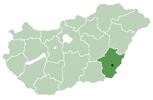
Kétsoprony is a village in Békés County,[1] in the Southern Great Plain region of south-east Hungary.
Geography
It covers an area of 51.24 km2 (20 sq mi) and has a population of 1,348 people (2013 estimate).[2]
Population
| Year | 1980 | 1990 | 2001 | 2010 | 2011 | 2013 |
|---|---|---|---|---|---|---|
| Population | 1,633 (census)[2] | 1,542 (census)[2] | 1,559 (census)[2] | 1,469 (estimate)[3] | 1,359 (census)[2] | 1,348 (estimate)[2] |
References
- ^ "Kétsoprony City Info". CitySeek.org. Retrieved 9 December 2013.
- ^ a b c d e f "Kétsoprony Population Table". citypopulation.de. Retrieved 9 December 2013.
- ^ "Helységnévkönyv adattár 2010". KSH (Hungarian Central Statisctical Office). 1 January 2010. Archived from the original on 7 November 2012. Retrieved 9 December 2013.
{{cite news}}: Unknown parameter|deadurl=ignored (|url-status=suggested) (help)
46°43′N 20°52′E / 46.717°N 20.867°E


