Light Pass, South Australia: Difference between revisions
Appearance
Content deleted Content added
m did general fixes if needed, replaced: See Also → See also |
Rescuing 2 sources and tagging 0 as dead. #IABot (v1.3.1.1) |
||
| Line 29: | Line 29: | ||
| near-nw = |
| near-nw = |
||
}} |
}} |
||
'''Light Pass''' is a settlement in the [[Barossa Valley]] region of [[South Australia]]. It was named by [[Charles Flaxman]] in honour of [[William Light]].<ref>{{cite web |
'''Light Pass''' is a settlement in the [[Barossa Valley]] region of [[South Australia]]. It was named by [[Charles Flaxman]] in honour of [[William Light]].<ref>{{cite web|url=http://maps.sa.gov.au/plb/# |title=Placename Details: Light Pass |work=Property Location Browser gazetteer |id=SA0039312 |date=22 November 2010 |publisher=Government of South Australia, Department of Planning, Transport and Infrastructure |accessdate=5 April 2015 |deadurl=yes |archiveurl=https://web.archive.org/web/20161012010923/http://maps.sa.gov.au/plb/ |archivedate=12 October 2016 |df= }}</ref> Light Pass is the site of two [[Lutheran Church of Australia|Lutheran]] churches<ref>{{cite web |url=http://www.lca.org.au/church-search-results.html?EntityID=469 |title=Light Pass Immanuel Evangelical Lutheran Church Incorporated |publisher=Lutheran Church of Australia |accessdate=5 April 2015}}</ref><ref>{{cite web |url=http://www.lca.org.au/church-search-results.html?EntityID=470 |title=Evangelical Lutheran Strait Gate Congregation |publisher=Lutheran Church of Australia |accessdate=5 April 2015}}</ref> and a public primary school.<ref>{{cite web |url=http://www.lightpassps.sa.edu.au/ |title=Welcome to Light Pass Primary School |publisher=[[Department for Education and Child Development]] |date=5 March 2014 |accessdate=5 April 2015}}</ref> |
||
[[file:Immanuel Lutheran church, Light Pass.JPG|thumb|Immanual Lutheran Church]] |
[[file:Immanuel Lutheran church, Light Pass.JPG|thumb|Immanual Lutheran Church]] |
||
Light Pass was previously served by the Light Pass railway station on the [[Barossa Valley railway line]], previously known as the Minkie station, derived from an Aboriginal word for ''daylight''. The station was near the intersection of Penrice and Light Pass Roads, slightly south of the town.<ref>{{cite web |
Light Pass was previously served by the Light Pass railway station on the [[Barossa Valley railway line]], previously known as the Minkie station, derived from an Aboriginal word for ''daylight''. The station was near the intersection of Penrice and Light Pass Roads, slightly south of the town.<ref>{{cite web|url=http://maps.sa.gov.au/plb/# |title=Placename Details: Minkie Railway Station |work=Property Location Browser gazetteer |id=SA0045159 |date=16 January 2009 |publisher=Government of South Australia, Department of Planning, Transport and Infrastructure |accessdate=5 April 2015 |deadurl=yes |archiveurl=https://web.archive.org/web/20161012010923/http://maps.sa.gov.au/plb/ |archivedate=12 October 2016 |df= }}</ref> |
||
==See also== |
==See also== |
||
Revision as of 16:40, 15 May 2017
| Light Pass South Australia | |||||||||||||||
|---|---|---|---|---|---|---|---|---|---|---|---|---|---|---|---|
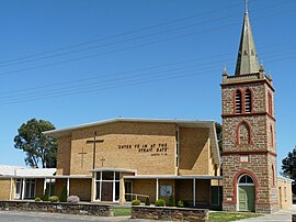
 Strait Gate Lutheran Church | |||||||||||||||
| Population | 256 (SAL 2021)[1] | ||||||||||||||
| Postcode(s) | 5355 | ||||||||||||||
| Location | 3 km (2 mi) E of Nuriootpa | ||||||||||||||
| LGA(s) | Barossa Council | ||||||||||||||
| State electorate(s) | Schubert | ||||||||||||||
| Federal division(s) | Barker | ||||||||||||||
| |||||||||||||||
Light Pass is a settlement in the Barossa Valley region of South Australia. It was named by Charles Flaxman in honour of William Light.[2] Light Pass is the site of two Lutheran churches[3][4] and a public primary school.[5]

Light Pass was previously served by the Light Pass railway station on the Barossa Valley railway line, previously known as the Minkie station, derived from an Aboriginal word for daylight. The station was near the intersection of Penrice and Light Pass Roads, slightly south of the town.[6]
See also
References
Wikimedia Commons has media related to Light Pass, South Australia.
- ^ Australian Bureau of Statistics (28 June 2022). "Light Pass (suburb and locality)". Australian Census 2021 QuickStats. Retrieved 28 June 2022.
- ^ "Placename Details: Light Pass". Property Location Browser gazetteer. Government of South Australia, Department of Planning, Transport and Infrastructure. 22 November 2010. SA0039312. Archived from the original on 12 October 2016. Retrieved 5 April 2015.
{{cite web}}: Unknown parameter|deadurl=ignored (|url-status=suggested) (help) - ^ "Light Pass Immanuel Evangelical Lutheran Church Incorporated". Lutheran Church of Australia. Retrieved 5 April 2015.
- ^ "Evangelical Lutheran Strait Gate Congregation". Lutheran Church of Australia. Retrieved 5 April 2015.
- ^ "Welcome to Light Pass Primary School". Department for Education and Child Development. 5 March 2014. Retrieved 5 April 2015.
- ^ "Placename Details: Minkie Railway Station". Property Location Browser gazetteer. Government of South Australia, Department of Planning, Transport and Infrastructure. 16 January 2009. SA0045159. Archived from the original on 12 October 2016. Retrieved 5 April 2015.
{{cite web}}: Unknown parameter|deadurl=ignored (|url-status=suggested) (help)
