Weather satellite
A weather satellite is a type of satellite that is primarily used to monitor the weather and climate of the Earth. These meteorological satellites, however, see more than clouds and cloud systems. City lights, fires, effects of pollution, auroras, sand and dust storms, snow cover, ice mapping, boundaries of ocean currents, energy flows, etc., are other environmental information collected from weather satellites.
Weather satellite images helped in monitoring the volcanic ash cloud from Mount St. Helens and activity from other volcanoes such as Mount Etna. Smoke from fires in the western United States such as Colorado and Utah have also been monitored.
Other environmental satellites can detect changes in the Earth's vegetation, sea state, ocean color, and ice fields. For example, the 2002 oil spill off the northwest coast of Spain was watched carefully by the European ENVISAT, which, though not a weather satellite, flies an instrument (ASAR) which can see changes in the sea surface.
El Niño and its effects on weather are monitored daily from satellite images. The Antarctic ozone hole is mapped from weather satellite data. Collectively, weather satellites flown by the U.S., Europe, India, China, Russia, and Japan provide nearly continuous observations for a global weather watch.
History

The first weather satellite, Vanguard 2, was launched on 17 February 1959. It was designed to measure cloud cover, but a poor axis of rotation kept it from collecting a notable amount of useful data.
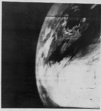
The first weather satellite to be considered a success was TIROS-1, launched by NASA on 1 April 1960. TIROS operated for 78 days and proved to be much more successful than Vanguard 2. TIROS paved the way for the Nimbus program, whose technology and findings are the heritage of most of the Earth-observing satellites NASA and NOAA have launched since then.
Types
There are two basic types of meteorological satellites: geostationary and polar orbiting.
Geostationary weather satellites orbit the Earth above the equator at altitudes of 35,880 km (22,300 miles). Because of this orbit, they remain stationary with respect to the rotating Earth and thus can record or transmit images of the entire hemisphere below continuously with their visible-light and infrared sensors. The news media use the geostationary photos in their daily weather presentation as single images or made into movie loops.
Several geostationary meteorological spacecraft are in operation. The United States has two in operation; GOES-11 and GOES-12. GOES-12 is designated GOES-East, over the Amazon River and provides most of the U.S. weather information. GOES-11 is GOES-West over the eastern Pacific Ocean. The Japanese have one in operation; MTSAT-1R over the mid Pacific at 140°E. The Europeans have Meteosat-6, Meteosat-7 and Meteosat-8 over the Atlantic Ocean and Meteosat-5 over the Indian Ocean. The Russians operate the GOMS over the equator south of Moscow. India also operates geostationary satellites which carry instruments for meteorological purposes. China operates the Feng-Yun(風雲) geostationary satellites. The most recent one is the FY-2C operating at 105°E. It was launched in October 2004.

Polar orbiting weather satellites circle the Earth at a typical altitude of 850 km (530 miles) in a north to south (or vice versa) path, passing over the poles in their continuous flight. Polar satellites are in sun-synchronous orbits, which means they are able to observe any place on Earth and will view every location twice each day with the same general lighting conditions due to the near-constant local solar time. Polar orbiting weather satellites offer a much better resolution than their geostationary counterparts due their closeness to the Earth.
The United States have the NOAA series of polar orbiting meteorological satellites, presently NOAA 12, NOAA 14 in standby, NOAA 15 and NOAA 16 as secondary spacecraft, NOAA 17 and NOAA 18 as primary spacecraft. Russia has the Meteor and RESURS series of satellites. China and India have polar orbiting satellites as well.
Visible-light images from weather satellites during local daylight hours are easy to interpret even by the average person; clouds, cloud systems such as fronts and tropical storms, lakes, forests, mountains, snow ice, fires, and pollution such as smoke, smog, dust and haze are readily apparent. Even wind can be determined by cloud patterns, alignments and movement from successive photos.
The thermal or infrared images recorded by sensors called scanning radiometers enable a trained analyst to determine cloud heights and types, to calculate land and surface water temperatures, and to locate ocean surface features. These infrared pictures depict ocean eddies or vortices and map currents such as the Gulf Stream which are valuable to the shipping industry. Fishermen and farmers are interested in knowing land and water temperatures to protect their crops against frost or increase their catch from the sea. Even El Niño phenomena can be spotted. Using color-digitized techniques, the gray shaded thermal images can be converted to color for easier identification of desired information.
Snowfield monitoring, especially in the Sierra Nevada, can be helpful to the hydrologist keeping track of how much snow is available for runoff vital to the water sheds of the western United States. This information is gleaned from existing satellites of all agencies of the U.S. government (in addition to local, on-the-ground measurements). Ice floes, packs and bergs can also be located and tracked from weather space craft.
Even pollution whether it's nature-made or man-made can be pinpointed. The visual and infrared photos show effects of pollution from their respective areas over the entire earth. Aircraft and rocket pollution, as well as condensation trails, can also be spotted. The ocean current and low level wind information gleaned from the space photos can help predict oceanic oil spill coverage and movement. Almost every summer, sand and dust from the Sahara Desert in Africa drifts across the equatorial regions of the Atlantic Ocean. GOES-EAST photos enable meteorologists to observe, track and forecast this sand cloud. In addition to reducing visibilities and causing respiratory problems, sand clouds suppress hurricane formation by modifying the solar radiation balance of the tropics. Other dust storms in Asia and mainland China are common and easy to spot and monitor, with recent examples of dust moving across the Pacific ocean and reaching North America.

The United States Department of Defense's Meteorological Satellite (DMSP) can "see" the best of all weather vehicles with its ability to detect objects almost as 'small' as a huge oil tanker. In addition, of all the weather satellites in orbit, only DMSP can "see" at night in the visual. Some of the most spectacular photos have been recorded by the night visual sensor; city lights, volcanoes, fires, lightning, meteors, oil field burn-offs, as well as the Aurora Borealis and Aurora Australis have been captured by this 450-mile-high space vehicle's low moonlight sensor.
At the same time, energy monitoring as well as city growth can be accomplished since both major and even minor cities, as well as highway lights, are conspicuous. This informs Astronomers of light pollution. The New York Blackout of 1977 was captured by one of the night orbiter DMSP space vehicles.
In addition to monitoring city lights, these photos are a life saving asset in the detection and monitoring of fires. Not only do the satellites see the fires visually day and night, but the thermal and infrared scanners on board these weather satellites detect potential fire sources below the surface of the Earth where smoldering occurs. Once the fire is detected, the same weather satellites provide vital information about wind that could fan or spread the fires. These same cloud photos from space tell the firefighter when it will rain.
In remote areas of the world where inhabitants are not readily available to detect fires, millions of acres rage out of control for days or even weeks before they are discovered. These satellites could be a tremendous asset to such places. These nighttime photos also clearly show the burn-off in the gas and oil fields of the Middle East and African countries. With the the burn-off, large amounts of carbon are being thrown into the atmosphere.
The most dramatic photos provided by all the weather satellites, but even more definitive were the DMSP night visual pictures of the 700 oil well fires that Iraq started on 23 February 1991 as they fled Kuwait. These fires were vividly illustrated as huge flashes on the night visual pictures far outstripping the glowing cities of the larger populated areas. The last of the 700 fires which spewed millions of gallons of oil, was doused on November 6. During the February to November time frame, the amount of black smoke put into the atmosphere created immeasurable effect to that region's ecological system, effect to human, animal and plant life, and went so far as to suppress normal 1991 hurricane activity in the eastern Atlantic.
See also
External links
- Space Applications for Development
- Near realtime composite of satellite image of the Earth
- Physical Characteristics of Geostationary and Polar-Orbiting weather satellites
- Earth at night
- Real-time Satellite Images - SSEC
- Interpreting Satellite Images - Suomi Virtual Museum
- Dr. Verner Suomi ("father of the geostationary satellite") biography
- Free Satellite Weather Links
