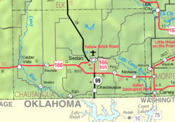
Wauneta, Kansas
Appearance
Wauneta, Kansas | |
|---|---|
 | |
| Coordinates: 37°06′47″N 96°22′50″W / 37.11306°N 96.38056°W[1] | |
| Country | United States |
| State | Kansas |
| County | Chautauqua |
| Elevation | 961 ft (293 m) |
| Time zone | UTC-6 (CST) |
| • Summer (DST) | UTC-5 (CDT) |
| Area code | 620 |
| FIPS code | 20-76025 |
| GNIS ID | 484426[1] |
Wauneta is an unincorporated community in Chautauqua County, Kansas, United States.[1]
History
[edit]Wauneta once had a post office; it closed in 1961. Wauneta once also had a grocery store, gas station and auto repair shop.[2]
References
[edit]- ^ a b c d U.S. Geological Survey Geographic Names Information System: Wauneta, Kansas
- ^ "Kansas Post Offices, 1828-1961, page 2". Kansas Historical Society. Retrieved June 6, 2014.
Further reading
[edit]External links
[edit]


