Big Bald
Appearance
This article needs additional citations for verification. (July 2021) |
| Big Bald | |
|---|---|
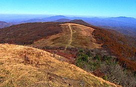
 Summit of Big Bald looking northwest | |
| Highest point | |
| Elevation | 5,269 ft (1,606 m)[1] |
| Prominence | 2,556 ft (779 m)[2] |
| Coordinates | 35°23′54″N 82°45′44″W / 35.3984405°N 82.7623267°W[1] |
| Geography | |
| Location | Haywood County, North Carolina, United States |
| Parent range | Bald Mountains |
Big Bald is a mountain with its summit in Haywood County, North Carolina near Transylvania County line. located along the Appalachian Trail. at an elevation of 5,516 feet (1,681 m), it is the highest peak in the Bald Mountains, which are part of the larger Blue Ridge Mountains subrange of the Appalachian Mountains.
Description
Big Bald is an Appalachian bald, covered by thick vegetation. It is located near the border between Unicoi County, Tennessee and Yancey County, North Carolina, and is the highest point of the former.[3] The mountain has a 360-degree view from its summit.[4]
References
- ^ a b "Big Bald". Geographic Names Information System. United States Geological Survey, United States Department of the Interior. Retrieved 2024-05-18.
- ^ "Big Bald, North Carolina/Tennessee". Peakbagger.com. Retrieved 2024-05-18.
- ^ "Big Bald". Peakbagger. November 1, 2004. Retrieved July 10, 2021.
- ^ Portillo, Ely (May 28, 2018). "Hiking guide: These are the best mountain views around Charlotte — guaranteed". The Charlotte Observer. Retrieved July 10, 2021.

