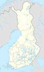
Salamajärvi National Park
Appearance
| Salamajärvi National Park | |
|---|---|
 | |
| Location | Finland |
| Coordinates | 63°16′N 024°45′E / 63.267°N 24.750°E |
| Area | 62 km2 (24 sq mi) |
| Established | 1982 |
| Visitors | 10500 (in 2009[1]) |
| Governing body | Metsähallitus |
| Website | www |
Salamajärvi National Park (Finnish: Salamajärven kansallispuisto) is a national park in the Central Ostrobothnia and Central Finland regions of Finland, in the municipalities of Perho, Kivijärvi and Kinnula. Salamajärvi is located in the rugged watershed region of Suomenselkä. This large, uninhabited area is especially known for its diverse mire ecosystems and its set of wilderness animals.
Salamajärvi National Park has about 60 km of marked trails. Many of them being challenging due the rocky nature but also some accessible trails and suitable for children.
See also
[edit]References
[edit]- ^ "Käyntimäärät kansallispuistoittain 2009" (in Finnish). Metsähallitus. Retrieved September 29, 2010.
External links
[edit] Media related to Salamajärvi National Park at Wikimedia Commons
- Outdoors.fi – Salamajärvi National Park
Categories:
- IUCN Category II
- National parks of Finland
- Protected areas established in 1982
- Geography of Central Ostrobothnia
- Geography of Central Finland
- Kivijärvi
- Perho
- Kinnula
- Tourist attractions in Central Finland Region
- Tourist attractions in Central Ostrobothnia
- 1982 establishments in Finland
- Ramsar sites in Finland
- Western Finland Province geography stubs
- European protected area stubs

