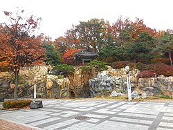
Ogeum-dong, Seoul
Appearance
Ogeum-dong | |
|---|---|
| Korean transcription(s) | |
| • Hangul | 오금동 |
| • Hanja | 梧琴洞 |
| • Revised Romanization | Ogeum-dong |
| • McCune–Reischauer | Okŭm-tong |
 Ogeum Park | |
 | |
| Coordinates: 37°30′14″N 127°08′06″E / 37.504°N 127.135°E | |
| Country | South Korea |
| Area | |
| • Total | 1.65 km2 (0.64 sq mi) |
| Population (2013)[1] | |
| • Total | 38,333 |
| • Density | 23,000/km2 (60,000/sq mi) |
Ogeum-dong is a neighbourhood, dong of Songpa-gu, Seoul, South Korea.[2][3]
Education
Schools located in Ogeum-dong:
- Seoul Gaerong Elementary School
- Seoul Geoyeo Elementary School
- Seoul Ogeum Elementary School
- Boin Middle School
- Ogeum Middle School
- Oju Middle School
- Seryun Middle School
- Boin High School
- Ogeum High School
Transportation
- Ogeum station of
 and of
- Bangi station of

- Gaerong station of

See also
References
- ^ "최근인구현황(주민등록인구)" [Recent population status (registered resident population)] (in Korean). Archived from the original on 2020-08-07.
- ^ "오금동 (Ogeum-dong 梧琴洞)" (in Korean). Doosan Encyclopedia. Retrieved 2008-04-15.[permanent dead link]
- ^ "The origin of the name and timetable of Ogeum-dong (동명 유래/연혁)" (in Korean). Ogeum-dong resident center. Retrieved 2008-04-15.
External links

