Bolívar Province, Peru
Appearance
Bolívar | |
|---|---|
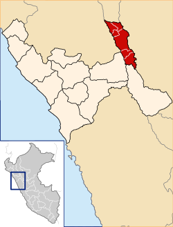
 Location of Bolívar in La Libertad Region | |
| Country | Peru |
| Region | La Libertad |
| Capital | Bambamarca |
| Government | |
| • Mayor | Carlos Alberto Peche Quiñones |
| Area | |
| • Total | 1,718.86 km2 (663.66 sq mi) |
| Elevation | 3,525 m (11,565 ft) |
| Population | |
| • Total | 17,550 |
| • Density | 10/km2 (26/sq mi) |
| UBIGEO | 1303 |
The Bolívar Province is a Peruvian province located in the La Libertad Region. It is one of the twelve provinces that make up that region.
Boundaries
[edit]- North Amazonas Region
- East San Martín Region
- South Pataz Province
- West Sánchez Carrión Province, Cajamarca Region
Political Division
[edit]The province has an area of 1,718.86 square kilometers (663.66 sq mi) and is divided into six districts:
Population
[edit]The province has an approximate population of 19,000 inhabitants
Capital
[edit]The capital of this province is the city of Bolívar.
See also
[edit]References
[edit]7°21′47″S 77°50′24″W / 7.36306°S 77.84000°W

