
User:Pampuco/sandbox
| Mynydd Eilian | |
|---|---|
 | |
| Highest point | |
| Elevation | 581 ft (177 m)[1] |
| Prominence | 404 ft (123 m)[1] |
| Parent peak | Mynydd Bodafon |
| Listing | HuMPs |
| Naming | |
| Language of name | Welsh |
| Geography | |
| Location | Anglesey, Wales |
| OS grid | xxx |
| Topo map | OS Landranger xxx |
Mynydd Eilian[2], sometimes also referred as Mynydd Llaneilian[3], is a prominent hill in Wales.
Etymology
The word Mynydd in Welsh stands for Mountain.[4] Eilian refers to Saint Elian (Welsh: Sant Eilian), to whom are named several nearby places and buildigs, like the village of Llaneilian[5], the Saint Eilian's Church [6]
Features

Mynydd Eilian, after the Mynydd Bodafon is the secon highest hill of the Isle of Anglesey.[7][8] The hill is located close to the NE extremity of Anglesey and overlooks the Point Lynas (Welsh: Trwyn Eilian)[9] Because of its topographic prominence the hill is classified as a HuMP.[2] Vith the Parys Mountain is a visual landmark of the nearby area.[10]
History
An archeologic site named Llys Caswallon, located some hundred metres E of the hilltop, was studied in the 2010s. Some clues lead to identify it as a prehistoric enclosure.[11]
Conservation
Mynydd Eilian is part of the Anglesey AONB[12], and some activities or construction works can be restricted because of it.[3] Around the hill was also extablished a RIGS named Mynydd Eilian RIGS Site, mainly in order to preserve some interesting outcrops of hornblende picrite outcrops. The rocks of the site date back to the Palaeozoic age.[13]
Access to the summit

The hill summit can be accessed from the village of Pengorffwysfa, at first by an asphalted lane and then following a public footpath.[14]
References
![]() Media related to Pampuco/sandbox at Wikimedia Commons
Media related to Pampuco/sandbox at Wikimedia Commons
- ^ a b "Mynydd Eilian, Wales". Peakbagger.com. Retrieved 5 July 2024.
- ^ a b Cite error: The named reference
hbwas invoked but never defined (see the help page). - ^ a b "12.1 Gweddill y Ceisiadau Remainder Applications" (PDF). Isle of Anglesey County Council. Retrieved 9 July 2024.
- ^ "Hil and mountain names". The Oxford Handbook of Names and Naming. Carole Hough (editor). Oxford University Press. 2016. ISBN 9780191630415. Retrieved 5 July 2024.
{{cite book}}: CS1 maint: others (link) - ^ Cite error: The named reference
Turbinewas invoked but never defined (see the help page). - ^ Barnes, David (2005). The Companion Guide to Wales. Companion Guides. p. 323. ISBN 9781900639439. Retrieved 7 July 2024.
- ^ "Seasonal adjustment - Anglesey". The Guardian. 7 September 2004. Retrieved 9 July 2024.
- ^ And the third highest hill of the Anglesey county after the Holyhead Mountain and the Mynydd Bodafon.
- ^ Krawiecki, Jim; Biggs, Andy (2006). Welsh Sea Kayaking - Fifty Great Sea Kayak Voyages. e:Pesda Press. p. 14. ISBN 9780954706180. Retrieved 9 July 2024.
- ^ Adrian Hadley (2016). "Archaeology Wales" (PDF). Archaeology Wales Limited. pp. 23–24. Retrieved 9 July 2024.
- ^ George Smith; David Hopewell (2010). "15. FIELDWORK: LLYS CASWALLON, LLANEILIAN". THE ANCIENT LANDSCAPE OF MôN ARCHAEOLOGY SURVEY PROJECT - Report No. 858 (PDF). Ymddiriedolaeth Archaeolegol Gwynedd / Gwynedd Archaeological Trust. pp. 34–37. Retrieved 9 July 2024.
- ^ "Map 2 - Dulas" (PDF). Isle of Anglesey County Council. Retrieved 9 July 2024.
- ^ "Mynydd Eilian RIGS Site". GeoMôn. Retrieved 9 July 2024.
- ^ "Mynydd Eilian & Fresh Water Bay from Llaneilian". Walking Britain. 2024. Retrieved 8 July 2024.
Panorama
-
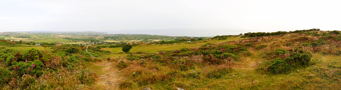 NE view from the hilltop
 -
 SW view from the hilltop


[[Category:Mountains and hills of Anglesey]] [[Category:Llaneilian]]