Visonta
Appearance
Visonta | |
|---|---|
Village | |
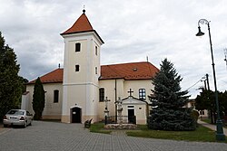
 Exaltation of the Holy Cross Church | |
| Coordinates: 47°46′48″N 20°01′48″E / 47.78000°N 20.03000°E | |
| Country | |
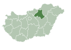
| County | Heves |
| District | Gyöngyös |
| First mentioned | 1279 |
| Government | |
| • Mayor | László Szarvas (Ind.) |
| Area | |
| • Total | 25.29 km2 (9.76 sq mi) |
| Population (2022) | |
| • Total | 1,159 |
| • Density | 46/km2 (120/sq mi) |
| Time zone | UTC+1 (CET) |
| • Summer (DST) | UTC+2 (CEST) |
| Postal code | 3271 |
| Area code | 37 |
| Website | www.visonta.hu |
Visonta is a village in Heves County, Hungary, beside of the Bene creek, under the Mátra mountain ranges. As of 2022 census, it has a population of 1159 (see Demographics). The village located 9.0 km from (Nr. 85) Vámosgyörk–Gyöngyös railway line, 2.1 km from the main road 3 and 13.3 km from the M3 motorway. The closest train station with public transport in Gyöngyös.
History
Demographics
According the 2022 census, 91.2% of the population were of Hungarian ethnicity and 8.8% were did not wish to answer. The religious distribution was as follows: 33.6% Roman Catholic, 4.6% Calvinist, 1.1% Greek Catholic, 15.6% non-denominational, and 42.6% did not wish to answer. 2 people live in a farm.[1]
Population by years:[2]
| Year | 1870 | 1880 | 1890 | 1900 | 1910 | 1920 | 1930 | 1941 |
|---|---|---|---|---|---|---|---|---|
| Population | 1067 | 1037 | 1025 | 1174 | 1348 | 1486 | 1423 | 1398 |
| Year | 1949 | 1960 | 1970 | 1980 | 1990 | 2001 | 2011 | 2022 |
| Population | 1466 | 1509 | 1342 | 1525 | 1328 | 1062 | 1194 | 1159 |
Politics
References
- ^ "Visonta". ksh.hu. Hungarian Central Statistical Office. Retrieved 22 July 2024.
- ^ "Population number, population density". Hungarian Central Statistical Office. Retrieved 2024-02-22.


