Typhoon
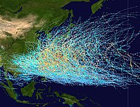
A Pacific typhoon or tropical storm is a tropical cyclone that forms in the northwestern Pacific Ocean. The basin is demarcated within the Pacific Ocean from Asia, north of the equator, and west of the international date line.[1] Storms from the Eastern and Central Pacific crossing the date line are re-designated as typhoons. This basin features the strongest cyclones on record.
Typhoon seasons include the entirety of the calendar year. Most storms tend to form between May and November.
The word "typhoon" comes from the Chinese 颱風/台风 (pinyin: tái fēng; Jyutping: toi4fung1).
Climatology
Nearly one-third of the world's tropical cyclones form within the Western Pacific. This makes this basin the most active.[2] Pacific typhoons have formed year round, with peak months from August to October. The peak months correspond to that of the Atlantic hurricane seasons. Along with a high storm frequency, this basin also features the most globally intense storms on record.
| Month | Count | Average |
|---|---|---|
| Jan | 28 | 0.6 |
| Feb | 15 | 0.3 |
| Mar | 26 | 0.6 |
| Apr | 39 | 0.8 |
| May | 64 | 1.4 |
| Jun | 96 | 2.0 |
| Jul | 215 | 4.6 |
| Aug | 312 | 6.6 |
| Sep | 262 | 5.6 |
| Oct | 219 | 4.7 |
| Nov | 134 | 2.9 |
| Dec | 75 | 1.6 |
| Annual | 1484 | 31.6 |
| Source: JTWC[3] | ||
| Rank | Name | Pressure | Location | Years |
|---|---|---|---|---|
| 1 | Typhoon Tip | 870 mbar | Western Pacific | 1979 |
| 2 | Typhoon Gary | 872 mbar | Western Pacific | 1992‡ |
| 2 | Typhoon Ivan | 872 mbar | Western Pacific | 1997‡ |
| 2 | Typhoon Joan | 872 mbar | Western Pacific | 1997‡ |
| 2 | Typhoon Keith | 872 mbar | Western Pacific | 1997‡ |
| 2 | Typhoon Zeb | 872 mbar | Western Pacific | 1998‡ |
| 7 | Typhoon June | 875 mbar | Western Pacific | 1975 |
| 8 | Typhoon Ida | 877 mbar | Western Pacific | 1958 |
| 8 | Typhoon Nora | 877 mbar | Western Pacific | 1973 |
| 10 | Typhoon Rita | 878 mbar | Western Pacific | 1978 |
| 10 | Typhoon Yvette | 878 mbar | Western Pacific | 1992‡ |
| 10 | Typhoon Damrey | 878 mbar | Western Pacific | 2000‡ |
| ‡ Minimum central pressure of these storms was estimated based on satellite data rather than directly measured. | ||||
Paths

Typhoon paths follow three general directions.[2]
- Straight. A general westward path affects the Philippines, southern China, Taiwan, and Vietnam.
- Recurving. Storms recurving affect eastern China, Taiwan, Korea, and Japan.
- Northward. From point of origin, the storm follows a northerly direction, only affecting small islands.
Basin monitoring
The following agencies monitor typhoons:
- Joint Typhoon Warning Center
- Philippine Atmospheric, Geophysical and Astronomical Services Administration (PAGASA)
- RSMC Tokyo-Typhoon Center, part of the Japan Meteorological Agency
Name sources
The list of names consist of entries from 17 East Asian nations and the United States who have territories directly affected by typhoons. The submitted names are arranged into five lists; and each list is cycled with each year. Unlike hurricanes, typhoons are not named after people. Instead, they generally refer to animals, flowers, astrological signs, and a few personal names. However, PAGASA retains its own naming list, which does consist of human names.[1] Therefore, a typhoon can possibly have two names. Storms that cross the date line from the Central Pacific retain their original name, but the designation of hurricane becomes typhoon.
See also
References
- ^ a b "How typhoons are named". USA Today. Retrieved 2008-08-18.
- ^ a b "Examining the ENSO" (PDF). James B Elsner, Kam-Biu Liu. 2003-10-08. Retrieved 2007-08-18.
- ^ "2005 Annual Tropical Cyclone Report: Western Pacific". JTWC. 2005. Retrieved 2007-08-26.
