Terrain-following radar
Terrain-following radar (TFR) is an aerospace technology that allows a very-low-flying aircraft to automatically maintain a relatively constant altitude above ground level. It is sometimes referred-to as ground hugging or terrain hugging flight. The term nap-of-the-earth flight may also apply but is more commonly used in relation to low-flying military helicopters, which typically do not use terrain-following radar.
Technology and usage
The system works by transmitting a radar signal towards the ground area in front of the aircraft. The radar returns can then be analysed to see how the terrain ahead varies, which can then be used by the aircraft's autopilot to maintain a reasonably constant height above the earth.
This technology is primarily used by military strike aircraft, to enable flight at very low altitudes (sometimes below 100 feet (30 meters)) and high speeds, avoiding detection by enemy radars and interception by anti-aircraft systems. This allows the pilot to focus on other aspects of the flight besides the extremely intensive task of low flying itself.
Some aircraft such as the Tornado IDS have two separate radars, with the smaller one used for terrain-following. However more modern aircraft such as the Rafale with phased array radars can look forwards and at the ground simultaneously.
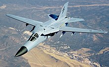
Most aircraft allow the pilot to select the ride "hardness", to choose between how closely the aircraft tries to keep itself close to the ground and the forces exerted on the pilot. The F-111 uses a switch to select for a hard, medium or a soft ride.
The TFR computer will consider many factors in determining the flight path for the aircraft. These factors include, distance to the forward terrain, aircraft speed and velocity, angle of attack and quality of signal being returned.

Terrain-following radar is also sometimes used by civilian aircraft that map the ground and wish to maintain a constant height over it.
Military helicopters may also have terrain-following radar. Due to their lower speed and high maneuverability, helicopters are normally able to fly lower than fixed wing aircraft.
Advantages and disadvantages
By flying at very low altitude, the aircraft can take advantage of terrain masking and avoid detection by enemy radar systems. The system is also largely automated and can take some of the workload off the pilot.
The radar emissions can be detected by enemy anti-aircraft systems with relative ease once there is no covering terrain, allowing the aircraft to be targeted. The use of terrain-following radar is therefore a compromise between the increased survivability due to terrain-masking and the ease with which the aircraft can be targeted if it is seen.
Since the radar cannot tell what is the beyond any immediate terrain, the flight path may suffer from "ballooning" over the top of high ground. Furthermore small obstacles such as radio antennas and electricity pylons may not show up on the radar at all. The objects present collision hazards when flying at very low level.
Even an automated system has limitations and all aircraft with terrain-following radars installed have limits on how low and fast they can fly. Factors such as system response-time, aircraft g-limits and the weather can all limit an aircraft.
Alternatives
There are very few alternatives to using terrain-following radar for high-speed, low altitude flight. TERPROM, a terrain-referenced navigation system provides a limited but passive terrain-following functionality.
List of aircraft with terrain-following radar
- A-400M
- A7A /B / C /D /E
- F-CK-1 C/D Hsiang Sheng
- B-1B
- B-52H
- C-5 Galaxy
- F-15E
- F-16
- F-105
- F-111
- Mirage 2000 N / D
- Rafale
- RF-4C Reconnaissance
- Tornado IDS
- Tupolev Tu-160
- Su-22
- Su-24
- A-6 Intruder
- MC-130E/H Combat Talon I/II
- MH-53(M)J Pave Low
- NHIndustries NH90
- CV-22B Osprey
- Su-34
- Su-30MKI
- HAL Tejas
References
- Krachmalnick, F.M., Vetsch, G.J., and Wendl, M.J. (1968) Automatic flight control system for automatic terrain-following, Journal of Aircraft 5(2), 168-175.
