
Lake Trasimeno
This article needs additional citations for verification. (December 2010) |
| Lake Trasimeno | |
|---|---|
| Location | Umbria, Italy |
| Coordinates | 43°08′N 12°06′E / 43.133°N 12.100°E |
| Type | laminar |
| Basin countries | Italy |
| Surface area | 128 km2 |
| Average depth | 4–5 m |
| Max. depth | 6 m |
| Surface elevation | 258 m |
| Islands | 3 (Isola Polvese, Isola Maggiore, Isola Minore) |


Lake Trasimeno (Italian: Lago Trasimeno; Latin: Trasumennus; Etruscan Tarśmina[1]), also referred to as Trasimene or Thrasimene in English, is the largest lake on the Italian peninsula south of the Po River with a surface area of 128 km2, slightly less than Lake Como. No major river flows directly into or out of Lake Trasimeno and the water level fluctuates significantly according to rainfall levels and the seasonal demands from the towns, villages and farms near the shore.
The lake
Trasimeno is shallow, muddy, rich in fish, including pike, carp, and tench. It is 4 meters deep on average. Lake Trasimeno is an endorheic body of water; it is an impounded lake that receives water but has no outlet. Other endorheic bodies of water include the Caspian Sea, Aral Sea, Utah's Great Salt Lake, and the Dead Sea. Evaporation can lead to a build up of minerals in the water, resulting in a saline conditions, making these lakes sensitive to pressures from pollution.
The shallow waters meant that malarial mosquitoes prospered. To combat malaria, some mosquito larvae-eating fish were imported from USA during the 1950s. These fish are widely scattered, and some live in the lakes near Trasimeno. Although billions of larvae are eaten, there are still many mosquitoes and other insects.
Trasimeno water quality is still very good, as a misuration of Italia Nostra showed in 2005. The lack of large farms in the area and a small population means a low pollution level.
A proposal to drain the lake to solve the problems of malaria and depth changes was rejected. At the end of the 19th century, the level changes were solved by building a channel near San Feliciano. This also lessened the malaria problem.
Origins and early history
Three million years ago, there was a shallow sea in this part of Umbria. A depression formed by geologic fractures allowed the present-day Lake Trasimeno to form.
Historically, Trasimeno was known as The Lake of Perugia, being important for northwestern Umbria and for the Tuscan Chiana district. In prehistoric times, this lake extended almost to Perugia. Trasimeno is a mythological figure, joined with Agilla, a nymph born in Agello, now a hill midway between Perugia and Trasimeno, formerly an island in the lake.
The Battle of Lake Trasimeno occurred on the northern shore of the lake in April 217 B.C. during the Second Punic War. The exact location of the battle is unknown because the lake then extended further north; the battle could have been fought between Cortona and Tuoro. Near Cortona, there is a place called 'Ossaia'.
The first civilization to inhabit this area was the Etruscans; three of the main Etruscan cities - Perugia, Chiusi, and Cortona - are within 20 km of the lake. Little physical evidence remains from the period of Etruscan or later Roman settlement. Castiglione del Lago, has some Roman ruins and its main streets are structured like a chessboard in the Roman style.
Local climate

The Trasimeno climate is quite warm, with moderate winters. Summers can be very warm and humid, but in general the lake moderates the climate both in cold and warm conditions because even swallow water gives a moderate thermic inertia. From May to September, the temperature is warm enough to allow swimming. In 1929, a cold winter froze the whole of the lake's surface, and cars could be driven over the ice. Cold winters in 1957, 1985 and 2002 caused heavy damage to the olive trees nearby. A less severe freeze happened in 1991. This is quite rare, given the latitude of this lake.
Trasimeno has high hills to the east, which help to capture rain and partially protect the lake from cold eastern winds. Most of the water in the lake comes from the network of streams on the western side of the lake.

After World War II, the lake's shores retreated a kilometre in the west; the eastern shore is deeper and more steeply sloped. In the early 1970s, the shore retreated again, by almost as much. In 1990, after a period of abundance, the lake level fell. In 2003, the shore retreated over 100 meters and the level fell 128 cm. The main reason is lack of rain. From 2004 to the summer of 2006, there was plenty of rain (over 150 mm in the last 20 days of August 2005 alone, with over 700 mm to the end of year), but the fall and winter of 2006 were very dry and hot throughout Italy. Despite this, the abundance of water that flowed into Trasimeno in the last 3 years has saved the lake from further problems. Water from the reservoir at Montedoglio in Tuscany to supply agriculture and lakeside towns and thereby eliminate the need to draw water from the lake, was due to open in 2011, but due to the collapse of part of the dam wall the project has been put on hold. [citation needed]
Conservation
The inhabitants of the communes around Trasimeno and the Umbrian people have successfully protected their lake, whose waters are fit for swimming and whose valleys and islands are intact environments. In 1995 a natural park was established over the entire surface and the shores. A 50 km bicycle path was opened in 2003 around the lake that allows tourists to explore it. There are also cross-country paths, especially over the hills on the eastern side.
The lake’s environs
Half of Trasimeno is surrounded by hills, rich in olives that are an important agricultural resource. On the western shore, near Tuscany, there are vineyards, and fruit and vegetables are grown. The hills are much lower and the climate is warmer. Monte Subasio near Assisi, about 70 km to the east, and Monte Amiata, about 70 km to the west, can be seen. The vegetation includes pines, willows and poplars around the shores, many over 30 m tall.
The main towns are Passignano sul Trasimeno, Tuoro, Monte del Lago, Torricella, S.Feliciano, S.Arcangelo, Castiglione del Lago, and Borghetto. Castiglione del Lago has the longest shore, being on the only significant peninsula of the lake. This may have been an island that was joined to the shore by the Romans.
Surrounding the lake are old small towns, and isolated castles, like Zocco castle and a tower near Passignano. Monte del Lago was originally built to control the road from Trasimeno to Perugia.
Aviation
The local airport, the Eleuteri, near Castiglione del Lago, was once one of the main aviation schools in Italy, with elegant buildings that were destroyed by retreating German troops in the summer of 1944. This airport was once almost as big as Castiglione. The mild climate and perfect visibility still allow the use of this airport for air meetings.
A social center exists in the former airport. A major watercourse, the Paganico torrent, separated the airport from the town.
Before this airport was constructed, there was a hydroscale in Castiglione del Lago. On the opposite shore, in Passignano, around 10 km away, there was an aircraft factory, the SAI Ambrosini. This is now abandoned as an industrial center, but is still used as an association center. It was founded around 80 years ago and the buildings still exist near the Passignano sul Trasimeno railway station. This company made several types of aircraft, designed by eng. Sergio Stefanutti. Aircraft were tested at Eleuteri airport, only few kilometers away from this factory. SAI was involved mainly with Macchi during World War II. Eleuteri was also used as test center for the Ambrosini SS.4, advanced canard aircraft, which crashed in the second flight and the project was abandoned.
Communications
Trasimeno is relatively far from every major Italian city, the nearest of which is Perugia. There was an historic railway built over 100 years ago, with the main rail station in Terontola. Smaller railway stations are in Passignano and Castiglione del Lago.
Because of increased traffic, about 30 years ago a highway was built over the Passignano's road to Perugia. This highway passes near the north and the east shores of Trasimeno and goes to Perugia and Assisi. Many smaller roads, such as the statal 75, are also present, especially on the western side of the lake. The A1 Autostrada passes five kilometers to the west of the Lake.
There are ferryboats, 3 small, 2 medium, and two big (two decks) called Perusia and Agilla II, based in Passignano Port, also two dredges. There are ports in Castiglione del Lago (recently totally rebuilt), S. Arcangelo, S. Feliciano, Tuoro, and several minor anchorages.
Islands

There are three islands in the lake. The largest of these islands is Isola Polvese, almost 1 km2. The second largest, Isola Maggiore, is the only inhabited one. The small fishing village, which reached its height in the 14th century, today has only around thirty residents. Most of the buildings, including the ruins of a Franciscan monastery, date from the 14th century.
Maggiore is a 'hill', while Polvese is a more complex structure with plains and hills, whilst Minore resembles a sloped table. Minore is now uninhabited, but in the past had a village with over 500 residents. Many centuries ago, a castle with a pentagonal structure stood near the shore, near an Olivetan monastery. The castle still remains, and the ruins of the church and the monastery are almost totally preserved, despite the abandonment in the 17th century due to malaria. The malaria was eradicated only in the 1950s. There were other problems, since Trasimeno was fought over by Chiusi, Panicale, Perugia, and Florence.

Florentine troops demolished Polvese in the 17th century, beginning its decline, until by the 19th century there was only a caretaker. Of the many houses, nothing remains.
Minore Isle, near Maggiore, is now uninhabited, totally covered by local vegetation except for a small anchorage. In ancient times, there was a separation between the two communities, because Polvese was far away from Maggiore-Minore. According to local stories, the wo communities fought against each other but the real problems were from the regional 'powers' that fought over this lake for centuries.
A fishing technique, called 'Tuoro' or 'pesca da tuori', was used locally. This complex system consisted of a wooden trap in the water and a circular structure to hold the net around it. The nets trapped the fish that were then taken to the village to be dried. This system worked with a high water level, but was abandoned when the level dropped. A mock up of this system was built several years ago near Polvese Isle's port.
Trasimeno's castles

There are castles all around Trasimeno, many in the center of small towns while others are isolated and in ruins. Castiglione del Lago, Passignano, Magione, Maggiore, and Polvese islands all have castles, while Zocco Castle, Montali Castle, and others are on hilltops.
The Guglielmi Castle in Maggiore Isle was built in the late 19th century on the foundation of an old Franciscan church, and for many years was a popular place in the Trasimeno area. Until 1998 it was still visitable, then it was closed because the structure became dangerous. It is now being restored by a new proprietor, but the work is far from completed.

Between Monte del Lago and S.Feliciano is Zocco castle, ruined for decades. It is privately owned but unmaintained. It is one of the biggest castles of the area and the only one that, inside its sandstone walls, has a still untouched medieval keep. Some years ago it was probably inhabited, as there is a building fitted with a TV antenna, but now its only entry is closed. The best-preserved parts are the eastern and the southern walls, increasingly endangered because the wall's faults are enlarging. The rest of the walls are mostly demolished or have fallen down. One of the southern towers has two enormous cracks in the middle.
The Vernazzano leaning tower, around 20 metres in height, leans like the famous leaning tower of Pisa. This unique remnant of an ancient castle was built before 1089, when the Marchiones family donated the whole castle to the monastery of Città di Castello. In 1202, it fell under control of Perugia and this city gained control of Northern Trasimeno. It was built on M.te Castiglione, near two rivers. The castle and the surrounding settlement at Vernazzano, were damaged by wars in 15th century and two centuries later, by a strong earthquake and after-shocks. Erosion of the foundations by water caused the tower to lean in the 18th century. Vernazzano was rebuilt in the valley, away from this site, which had been effective for territorial control but was less well-suited for living in. The Leaning Tower has therefore been abandoned for almost 300 years. To avoid its collapse, a steel reinforcement was recently added, with plates and wires even thicker than 2–3 cm. The Tower is not well known, being located away from the main streets. It is visible from far away, but not easily accessible.
Image gallery
-
 Tree remains on Trasimeno's shores. They were planted when the lake's level was much lower and died when it rose.
 -
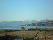 The lake seen from Montebuono di Magione.
 -
How SIAI born in 1916 is explained there, in the front of the factory.
-
 The Leaning Tower. Note the number of steel cables recently added to preserve it.


See also
- Battle of Lake Trasimene (in the Second Punic War)
- Trasimene Line, battle in World War II
- Trasimène, département of the First French Empire