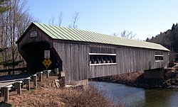
Bartonsville Covered Bridge
Appearance
Bartonsville Covered Bridge | |
 The Northeast approach to the Bartonsville bridge | |
| Location | Bartonsville, Vermont |
|---|---|
| Built | 1871 |
| Architect | Granger,Sanford |
| NRHP reference No. | 73000201 [1] |
| Added to NRHP | July 2, 1973 |
The Bartonsville Covered Bridge was a wooden covered bridge in the village of Bartonsville, in Rockingham, Vermont, United States. Built in 1870 by Sanford Granger, the bridge was a lattice truss style with a 151 foot span across the Williams River. The bridge is listed on the National Register of Historic Places.
It was located on Lower Bartonsville Road, a paved road a short distance north from Vermont Route 103. Nearby, to the east, is the Worrall Covered Bridge, also built by Granger.
On August 28, 2011, the bridge was destroyed due to flash flooding because of Hurricane Irene's landfall upon the eastern seaboard dumping torrential rain throughout the state of Vermont.[2]
References
- ^ "National Register Information System". National Register of Historic Places. National Park Service. January 23, 2007.
- ^ Flooding takes toll on historic bridges, WCAX.com
Categories:
- Bridges on the National Register of Historic Places in Vermont
- Covered bridges in Vermont
- Rockingham, Vermont
- Bridge disasters in the United States
- Bridges completed in 1871
- Wooden bridges in the United States
- Buildings and structures in Windham County, Vermont
- Transportation in Windham County, Vermont
- Visitor attractions in Windham County, Vermont
- Washouts
- Vermont building and structure stubs
- United States bridge (structure) stubs
