
Hengistbury Head
 View from Warren Hill overlooking Mudeford Spit | |
| Location | near Christchurch |
|---|---|
| Region | Dorset, England |
| Coordinates | 50°42′53.17″N 1°45′17.68″W / 50.7147694°N 1.7549111°W |
| Type | Ancient Monument, Local Nature Reserve, SSSI |
| History | |
| Periods | Stone Age, Bronze Age and Iron Age |
| Site notes | |
| Condition | well preserved |
Hengistbury Head (/ˈhɛŋɡəstbri/) is a headland jutting into the English Channel between Bournemouth and Milford on Sea in the English county of Dorset. It is a site of international importance in terms of its archaeology and is scheduled as an Ancient Monument.[1] Declared a Local Nature Reserve in 1990, the head and its surroundings form part of the Christchurch Harbour Site of Special Scientific Interest.[2] It is also a Special Area of Conservation, Special Protection Area, an Environmentally Sensitive Area and a Site of Nature Conservation Interest.[3] The name "Hengistbury Head" refers to the immediate area, the elevated portion is called Warren Hill.
Location
Hengistbury Head is a sandstone headland which forms part of Southbourne. It is the most easterly part of the Borough of Bournemouth, and marks the most easterly point of Poole Bay. The northern slope of the hill tailing off towards the sea forms Mudeford spit, the sand bar closing Christchurch Harbour from the south.
The spit is home to over 300 privately owned beach-huts. In 2012, one of the huts may have become the UK's most expensive beach hut, fetching £170,000 after just two days on the market.[4] The hut measures a little over five by three metres square, has no running water, and the occupants may only stay overnight from March to October. Despite the relative lack of amenities, the area has become one of the UK's most desirable, with huts being rented out for up to £600 a week.[5]
The Black House, a local landmark, stands at the end of the spit, opposite Mudeford Quay, site of the Battle of Mudeford in 1784. Once a boat-builders' house and now rented out to holidaymakers, it has served a variety of functions over the years though it is commonly associated with the area's smuggling past.[6]
Etymology
Mentioned as Hednesburia in deed of the early 12th century, and referred to as Hynesbury Head in the 17th, Hengistbury only took on it's current spelling in the 19th century, during a period of what archaeologist Barry Cunliffe calls "antiquarian romanticism".[7] Many prehistoric sites around this time were renamed to link them with historical figures.[7] It was thought at the time that the legendary Anglo-Saxon leader Hengist could well be buried here, as he was said to have been laid to rest in an unlocated mound, however, the tumuli at Hengistbury Head date to the Bronze Age as 20th century excavations have discovered.[8]
History
Hengistbury Head is home to a plethora of nationally and internationally significant archaeological sites, spanning a period stretching from the Late Upper Palaeolithic through to the Roman settlement of Britain,[9] earning the site Scheduled Ancient Monument status. Interest in the site declined throughout the Dark Ages, until extensive development took place in Christchurch around 890 AD, when the Head may have been used as a lookout post. The area was heavily quarried during the Victorian period and nowadays receives over a million visitors annually.[10]
Stone Age
Several archaeological digs have revealed that the site was occupied during the Upper Palaeolithic.[11] There is evidence of an open settlement of the Creswellian culture on the hill in the middle of the headland dating to around 10,500 BC. After the ploughing of Warren Hill in 1913, thousands of flint implements covering the entire Stone Age were discovered.[12] Most interesting were several blades typically found at Upper Paleolithic sites across Europe, but rarely seen outside of caves in the UK, where open air sites of this age are extremely rare.[13] People at the Head were heavily involved with the production of blades, further excavations identified 649 tools, dominated by backed blades, endscrapers and burins.[14] At the time the hill would have overlooked a large river valley that was to become the English Channel. Once the sea had inundated the surrounding valley, Mesolithic hunter gatherers exploited the site. Pollen analysis of peat from the Solent bed suggest the headland was lightly wooded at this time, free of dense undergrowth, making it a good home for deer and other game.[15]
Bronze Age
Eleven Bronze Age round barrows sit on the promontory with two more a little further inland. Eleven of the round barrows were excavated; three by Bushe Fox in 1911-12 and eight by Harold St George Gray in 1919 and 1922.[16][8] Two appear to be undisturbed. Numerous finds including Early Bronze Age axes and cremation urns were recovered from these tumuli, which have been consistently found to be between 3500 and 4000 years old.[8] One of the barrows (south of where the thatched barn now stands[17]) contained a high status cremation of a woman of about twenty years in age, accompanied by an incense cup, a halberd-style pendant made from amber and copper alloy, and two gold cones that would have covered buttons of an organic material.[18] These finds can be closely paralleled with Wessex culture burials, particularly those of the Wilsford and Dorset Ridgeway series.[16] An urn from one of the barrows likely to have been made between 1700 and 1500 B.C., has been identified as Trevisker ware, a type widely found throughout Devon and Cornwall which was transported east in lesser amounts, this find being one of the easternmost discovered.[19]
Iron Age

In around 700 BC, a settlement on the headland was established;.[20] also around this time, the headland was cut off from the mainland by the construction of two banks and ditches called the Double Dykes,[21] similar to those found at Maiden Castle. The earthworks consisted of an inner bank three metres high, with a ditch three and a half metres deep. An outer ditch six metres wide and two metres in depth which is now obscured due to wind-blown deposits of sand and a gradual silting process.[22] These defences turned Hengistbury Head into a fortified settlement area which seems to have grown over succeeding centuries until it became an important port.[23]
Due to the high concentration of iron ore in the area, this location became a significant trade centre, trading worked metal - iron, silver, and bronze - with the Continent in return for wine, tools, and pottery. John Lavender of the local Red House Museum noted evidence of small iron-ore smelting hearths on Warren Hill,[24] while green vitreous slag has been also found on the Head.[24] In his 1911 to 1912 excavations, Bushe-Fox found evidence for working of lead, copper and silver.[24] Two ingots discovered at this time revealed importing of raw materials to the area.[25] One ingot was of nearly pure copper,[25] while the other, which weighed 8.6 kg, was roughly 50/50 copper-silver alloy with around one percent gold.[24] Many coins have been found from this period (making it one of the few areas in pre-Roman Britain to use coins). Interestingly, some of them were fake - worthless cores dipped in silver.[26]
The Iron Age port at Hengistbury Head forms a final site in a small chain of fortified earthworks, starting from Hambledon Hill, and also including Hod Hill, Spetisbury Rings, Buzbury Rings, Badbury Rings and Dudsbury Camp.[27]
Roman occupation to Medieval period
Under the Romans, Hengistbury Head was initially left alone, possibly as a result of its distance from Roman centres of power. However, as Roman rule expanded, trade was moved away from the Head to other Roman ports. Consequently, the region saw a decline in prosperity, and indeed, by about the time the Romans left (c.410 AD), the area was abandoned.
The area was not substantially reoccupied until Alfred the Great decided to rebuild the harbour as a defence against raiders. He built the town that later became Christchurch, on the north side of the harbour. Access to Salisbury up the River Avon made this a more strategic place. The Head may have been used for harbour defense at this time. In the 11th century, some of the iron-ore rich stones found at the Head were used in the construction of Christchurch Castle. These reddish-coloured stones can still be seen in the base of the now ruined castle.[28]
17th, 18th and 19th centuries
In the late 1600s, Andrew Yarranton (with backing from the Earl of Clarendon) commenced a scheme to improve the harbour. A channel was cut out to sea and ironstone boulders from the head were used to create a pier. The plans proved ineffective; the pier was poorly positioned and subsequent storms (including the Great Storm of 1703) soon undid most of the work although parts of the pier known as "Clarendon's Jetty" or the "Long Rocks" are still visible today.[29] Thousands of tons may have been removed from the beach and the head itself to make the jetty.

In 1733 a new Excise and Customs Bill was introduced, restricting imports and raising taxes on many luxury items. Christchurch rapidly became a hot-bed for smugglers, where they were known as "freetraders", and much of the town was involved in the trade. The "Double Dykes" provided excellent cover for the wagon trains used to transport casks of illicit brandy and wine,[30] while the Black House was used in the construction of "Guinea boats"[31] (cheaply built galleys sometimes capable of outrunning the day's steamships).[32] The house acquired its distinctive black colour when Customs Officers tried to smoke out some holed-up smugglers by lighting fires around the base.[31] Smuggling continued at and around the site until the mid-1850s.
From 1848 to 1872, the Hengistbury Mining Company - formed by a Christchurch-based merchant, John E. Holloway - extracted many more ironstone boulders. Holloway brought coal from Southampton, and took the ironstone as ballast for the return journey.[33] These boulders, known as Iron Doggers, were prized for their high quantity of iron ore (up to 30%).[28] They form the base of Hengistbury Head, and the removal of a substantial amount of doggers over the years has weakened the headland. These and earlier excavations resulted in a loss of up to a third of the Head, caused mainly by erosion after the quarry's closure. The silt being washed down also threatened the ecology of the saltmarsh below. This has been reduced by the building of a dam, in 1976, to create a pool. Many "doggers" can still be seen lining the route of the land-train and at the quarry.
The Head today


Hengistbury Head Local Nature Reserve is currently owned and managed by Bournemouth Borough Council. In 1990, the land was declared a Local Nature Reserve, as a commitment by the town of Bournemouth to conserving and enhancing the environment.[34] The heathland forms part of the Dorset Heaths and is internationally protected as a Special Area of Conservation and Special Protection Area. Nearby, the upper reaches of Christchurch Harbour (including the meadows at Wick) are recognized as an Environmentally Sensitive Area.[34]
The head today is used for a variety of reasons. Firstly it is a tourist spot where country walks can be taken all over the head due to the well defined gravel paths, some of which form part of the Bournemouth Coast Path. In 2008, many paths were resurfaced, making more (though not all) parts of the Head wheelchair accessible. For example, it is now possible to gain wheelchair access to Quarry Pool. Regular field trips to the site are made by students of all ages and there are occasional guided tours or meetings around the Head covering a wide variety of subjects.
There is a cafe at the bottom of the head on the Bournemouth side. A scenic land train (known as "the Noddy train") makes regular journeys from the cafe to the end of the spit, a journey of ten or so minutes. On the head itself is a H. M. Coastguard radio relay station, a nature reserve and a triangulation pillar, shown on Ordnance Survey maps as 36 metres above sea level. Ample parking (subject to charges) can be found near the cafe, but the Head is also within walking distance of Southbourne and parts of Christchurch. By the car park is a hut containing further information about the head. On windy days the head is very good for kite flying.
The Quarry Pool is now a significant part of the nature reserve features of the Head. While it was very acidic in the early years, since 1990 it has allowed the growth of a significant number of plant and insect species, as well as mallard and little grebe. The insects provide valuable food for migrating martins and swallows.[35]
Due to the dense bracken and grass on many parts it has suffered several severe fires in the past decade. Care must be taken not to leave glass bottles lying on the ground and to dispose of cigarettes carefully, especially in summer months. Luckily the ecosystem is quick to heal itself so evidence of this is not easily found.
Hengistbury Head visitor centre
A new visitor centre for Hengistbury Head is scheduled to open in the summer of 2013.[36] Work is currently proceeding on an extension to the thatched barn, which is being made in a way that will minimize energy costs and its impact on the environment.[36] It is being funded with £300,000 from developer contributions, £432,000 from the Heritage Lottery Fund and £300,000 from landfill tax.[36]
The centre will be home to an exhibition area for archaeology, ecology and geology celebrating 14,000 years of Bournemouth’s prehistory.[37] Work space will be created for volunteers and other community groups such as the Hengistbury Head Supporters Group, Residents’ Association and Christchurch Harbour Ornithological Group.[37] The public will have the chance to see and handle some of the archaeological finds unearthed at Hengistbury Head in the last 100 years and the centre will also enable visitors to interact with knowledgeable staff and will provide them with the opportunity to become actively involved as volunteers in the running of the centre and the nature reserve.[37]
The surrounding area will be extensively landscaped to create outdoor learning areas and a wildlife garden.[38] As well as solar panels for electricity and ground source heat pump for heating, the energy-saving features will include a green roof (a living roof that is partially or completely covered with vegetation and a growing medium), used to absorb rainfall and provide insulation.[36] The centre will be constructed using timber-frame walls insulated with straw bales.[39]
Geology
According to Ian West of Southampton University, "Hengistbury Head is the best part of the Bournemouth coast for geology and geomorphology.. ..[and] is geologically important for the unusual nodules of sideritic ironstone [found] in Middle Eocene strata."[40] The exposed and relatively untouched cliff face at the Head perfectly lends itself to students of Lithostratigraphy. Warren Hill itself is composed of Tertiary Bracklesham Beds[41], a mixture of clays and marls with overlying sandy and lignitic beds.
Erosion
One serious threat to the future of the Head is erosion of the exposed southern cliff face from wind and rain, as well as erosion caused by the sea primarily through the process known as Longshore drift. A comparison of Ordinance Survey maps reveals that 25 metres of cliff was washed away from 1915 to 1962,[41] a process accelerated by the Bournemouth cliff's concreted promenade and groynes, construction of which started in the early 20th century. It is thought that in the last 200 years around 150 metres of land has been lost from the Head.[41] The first attempt to counteract erosion came in the 1930s when Bournemouth Council constructed a breakwater now known as "the Long Groyne".[42] Since then, a gabion revetment has been constructed to secure the weakest point at the eastern end of the Head.[28] In a long-term project to secure the Head's future, from 2005 to 2008 Poole Bay was replenished with 1.8 million cubic metres of beach material,[43] drawing ire from some surfers and beach lovers, due to the increase in sharp stones on Southbourne beach in particular.[44] The project's organizers, the Poole Bay Partnership, state that: "The resulting wide beaches have been a success in terms of their function as a coast protection structure and for the enjoyment they provide to the area's residents and visitors."[43]
Flora and fauna


Hengistbury Head forms part of the Christchurch Harbour Site of Special Scientific Interest (SSSI) which supports 500 plant species (a quarter of the national flora), including eight red data book species, 14 nationally scarce, and 39 locally rare species. The main nature reserve area faces Christchurch Harbour, and is contiguous with the reed beds of Wick Fields. The Head contains a large variety of habitats from the heathland on Warren Hill to freshwater ponds, sand dunes, and salt marshes. The woodland is home to English Oak and Silver Birch amongst many other trees, and is of particular interest, as it is the only such area to be shown on an 1811 O.S. map of the Bournemouth/Christchurch area.[45] In 2002, cattle grazing commenced in a field near the new visitor centre known as "Barn Field". This, combined with gorse eradication, has assisted in the restoration of this habitat to its ancient character.[46]
Present on the site is Sea knotgrass (Polygonum maritimum), the rarest of the knotgrasses in Britain,[47] and currently listed as a "schedule 8 species" under the Wildlife and Countryside Act 1981. Such plants are afforded greater than usual protection against damaging activities - such as "cutting, picking, destroying or selling."[48]
The various habitats provide homes to numerous species of insects. There are 700 moth species recorded in the nature reserve, again a quarter of the national total. At different spots across the site butterflies (including the Green Hairstreak),[49] damselflies (like the Large Red), and dragonflies (such as the "Hairy") can be observed.[45][50][51] The exceedingly rare thirteen-spotted ladybird (Hippodamia 13-punctata), was recently observed at the Head, the first recorded UK sighting since 1952.[45]
Over 300 species of birds have been recorded in the area,[52] making Hengistbury Head an important migratory point. The Balearic Shearwater, considered critically endangered with extinction by the IUCN and seldom sighted in the UK, has been seen in the area.[53] Other rare birds spotted here include the Purple Heron, the Pink-footed Goose, the Honey Buzzard and the Melodious Warbler to name but a few.[54] The fields and reserved areas near the car park provide an ideal spot to watch and listen to a significant population of skylarks during the summer months.
In 1989 a project was started to re-introduce the country's rarest amphibian, the Natterjack Toad, to Hengistbury Head. The Natterjack was last recorded on the headland in the 1950s before its extinction, likely the result of lack of suitable ponds.[55] The project has been a great success and today there are thriving populations at various locations.[55] The ideal time to witness their mating rituals is in May as dusk approaches, when the distinctive call of the Natterjack can be heard for miles around.[56]
See also
References
- ^ Hengistbury Head Nature Reserve
- ^ Hengistbury Head Nature Reserve
- ^ Bournemouth Borough Council website, Hengistbury Head Local Nature Reserve
- ^ Hilary Osborne (Monday 18 June 2012). ""Beach hut property near Bournemouth sells for £170,000"". The Guardian. Retrieved 17 March 2013.
{{cite news}}: Check date values in:|date=(help); Italic or bold markup not allowed in:|newspaper=(help) - ^ Mudeford Sandbank Beach Hut Association website
- ^ Black House Beach Holiday Apartments website. History of the Black House
- ^ a b Cunliffe, Barry (1978). Hengistbury Head. Elek Books Ltd. p. 15. ISBN 0236401254.
{{cite book}}:|access-date=requires|url=(help) - ^ a b c Cunliffe, Barry (1978). Hengistbury Head. Elek Books Ltd. p. 23. ISBN 0236401254.
{{cite book}}:|access-date=requires|url=(help) - ^ New CAHO fieldwork at Hengistbury Head started :: Archaeology, School of Humanities
- ^ Hengistbury Head Visitor Centre Project details, Bournemouth Borough Council website.
- ^ Cunliffe, Barry (1978). Hengistbury Head. Elek Books Ltd. pp. 18–20. ISBN 0236401254.
{{cite book}}:|access-date=requires|url=(help) - ^ Cunliffe, Barry (1978). Hengistbury Head. Elek Books Ltd. p. 18. ISBN 0236401254.
{{cite book}}:|access-date=requires|url=(help) - ^ Cunliffe, Barry (1978). Hengistbury Head. Elek Books Ltd. p. 20. ISBN 0236401254.
{{cite book}}:|access-date=requires|url=(help) - ^ Pettitt, Paul; White, Mark (2012). The British Palaeolithic: Human Societies at the Edge of the Pleistocene World. p. 472. ISBN 1136496777.
- ^ "The archers of Hengistbury Head", New Scientist Peter James, 3 May 1984
- ^ a b Pastscape - Detailed Result: HENGISTBURY HEAD
- ^ Hengistbury Head Nature Reserve - Bronze Age
- ^ Cunliffe, Barry (1978). Hengistbury Head. Elek Books Ltd. pp. 21, 82. ISBN 0236401254.
{{cite book}}:|access-date=requires|url=(help) - ^ Cunliffe, Barry (1978). Hengistbury Head. Elek Books Ltd. p. 25. ISBN 0236401254.
{{cite book}}:|access-date=requires|url=(help) - ^ Cunliffe, Barry (1978). Hengistbury Head. Elek Books Ltd. pp. 26–28. ISBN 0236401254.
{{cite book}}:|access-date=requires|url=(help) - ^ Cunliffe, Barry (1978). Hengistbury Head. Elek Books Ltd. p. 35. ISBN 0236401254.
{{cite book}}:|access-date=requires|url=(help) - ^ Cunliffe, Barry (1978). Hengistbury Head. Elek Books Ltd. p. 33. ISBN 0236401254.
{{cite book}}:|access-date=requires|url=(help) - ^ Hoodless WA, Hengistbury Head - The whole story, page 24. Poole Historical trust. 2005. ISBN 1-873535-60-0.
- ^ a b c d Cunliffe, Barry (1978). Hengistbury Head. Elek Books Ltd. p. 40. ISBN 0236401254.
{{cite book}}:|access-date=requires|url=(help) - ^ a b Cunliffe, Barry (1978). Hengistbury Head. Elek Books Ltd. p. 40. ISBN 0236401254.
{{cite book}}:|access-date=requires|url=(help) - ^ Hengistbury Head
- ^ Hill Forts of the Stour Valley by David E. C. Jardine, 1985, Bournemouth Local Studies Publications
- ^ a b c Hengistbury Head Coastal Defence.
- ^ 17th century at Hengistbury Head
- ^ 18th century at the Head
- ^ a b History at the Black House. Black House Holiday Apartments
- ^ Richard Platt Smugglers Britain, Guide-Book: South-East England
- ^ First section of information sign posted at Quarry Pool
- ^ a b Hengistbury Head Nature Reserve, hengistburyhead.org
- ^ Second section of information sign posted at Quarry Pool
- ^ a b c d BBC News - Hengistbury Head visitor centre built with straw walls
- ^ a b c Hengistbury Head Visitor Centre
- ^ Plan of the Visitor Centre, showing landscaping and outdoor areas.
- ^ ModCell :: Hengistbury Head visitor centre onsite
- ^ Hengistbury Head Geology, Dorset - by Ian West
- ^ a b c Cunliffe, Barry (1978). Hengistbury Head. Elek Books Ltd. p. 11. ISBN 0236401254.
{{cite book}}:|access-date=requires|url=(help) - ^ The head in the 20th century
- ^ a b Poole Bay Coastal Management | Coast Protection | Flood Defence | Swanage Poole Bournemouth Christchurch
- ^ Rees, Ceri. "Replenished beach 'now a disaster'". Daily Echo. Retrieved 16 March 2013.
{{cite web}}: Italic or bold markup not allowed in:|publisher=(help) - ^ a b c Bournemouth Coucil, Hengistbury Head Action plan, 2005, pdf.
- ^ Bournemouth Council Hengistbury Head Management plan 2011(draft)
- ^ Plants & Fungi: Polygonum maritimum (sea knotgrass) - Species profile from Kew
- ^ Wild plants: dangerous, invasive and protected species - Detailed guidance - GOV.UK
- ^ Hengistbury Head.org, Nature, Woodland.
- ^ Christchurch Harbour Ornithological Group, Odonata list.
- ^ Hengistbury Head Local Nature Reserve
- ^ Christchurch Harbour Ornithological Group (CHOG) Bird list for Christchurch Harbour area
- ^ CHOG | Harbour List
- ^ Christchurch Harbour Ornithological Group website, Rarities
- ^ a b Hengistbury Head Nature Reserve
- ^ BBC Nature - Natterjack toad videos, news and facts
External links
- Extensive notes on the geology of the area, with great images
- A site run by the Hengistbury Head Supports Group
- Website of the Christchurch Harbour Ornithological Group. Detailed information on birds (and other species) in the area
- Details and plans of the new visitor centre
- Laymans guide to Hengistbury Head geology and history
- Hengistbury Head at the modern Antiquarian
- Gallery of artist Alan Hayden, who has spent over twenty years painting the Head and surrounding area
Images
Views from various parts of Hengistbury Head or nearby.
-
 Christchurch from Warren Hill, across the harbour
 -
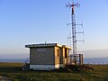 Coastguard radio relay station on Hengistbury Head
 -
 Toposcope, indicating views from Hengistbury Head, supplied by the Rotary Club of Boscombe and Southbourne
 -
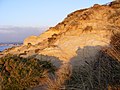 Hengistbury Head, cliff face on western end.


