Jászfényszaru
Appearance
Jászfényszaru | |
|---|---|
 | |
| Country | |
| County | Jász-Nagykun-Szolnok |
| Area | |
| • Total | 76.16 km2 (29.41 sq mi) |
| Population (2001) | |
| • Total | 5,887 |
| • Density | 77.3/km2 (200/sq mi) |
| Time zone | UTC+1 (CET) |
| • Summer (DST) | UTC+2 (CEST) |
| Postal code | 5126 |
| Area code | 57 |

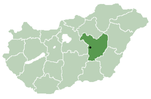
Jászfényszaru is a town in Jász-Nagykun-Szolnok county, in the Northern Great Plain region of central Hungary.

Geography
It covers an area of 76.16 km2 (29 sq mi) and has a population of 5887 people (2001). It is the meeting of three regions: the North-Hungary, the North-Plain and the Central region. The neighbouring towns are: Hatvan, Csány and Boldog (Heves county), Pusztamonostor (Jász-Nagykun-Szolnok county), Zsámbok, Szentlőrinckáta and Tóalmás (Pest county). Jászfényszaru is at the mouth of Zagyva and Galga rivers. The town has 2 twin-cities: Zakliczyn (Poland) and Bors (Romania).
Population (2006): 5916 people
It has the second largest Samsung factory in Europe after the Slovakian one.


