
Talk:Control of cities during the Syrian civil war
| This is the talk page for discussing improvements to the Control of cities during the Syrian civil war article. This is not a forum for general discussion of the article's subject. |
Article policies
|
| Find sources: Google (books · news · scholar · free images · WP refs) · FENS · JSTOR · TWL |
| Archives: Index, 1, 2, 3, 4, 5, 6, 7, 8, 9, 10, 11, 12, 13, 14, 15, 16, 17, 18, 19, 20, 21, 22, 23, 24, 25, 26, 27, 28, 29, 30, 31, 32, 33, 34, 35, 36, 37, 38, 39, 40, 41, 42, 43, 44, 45, 46, 47, 48, 49, 50, 51, 52, 53, 54, 55, 56, 57, 58, 59, 60, 61, 62, 63, 64, 65Auto-archiving period: 14 days |
| This page is not a forum for general discussion about Control of cities during the Syrian civil war. Any such comments may be removed or refactored. Please limit discussion to improvement of this article. You may wish to ask factual questions about Control of cities during the Syrian civil war at the Reference desk. |
| This article is of interest to the following WikiProjects: | |||||||||||||||||||||||||||||||||||||||||||||
Please add the quality rating to the {{WikiProject banner shell}} template instead of this project banner. See WP:PIQA for details.
Please add the quality rating to the {{WikiProject banner shell}} template instead of this project banner. See WP:PIQA for details.
| |||||||||||||||||||||||||||||||||||||||||||||


.svg)
| To help centralise discussions and keep related topics together, Template talk:Syrian Civil War detailed map redirects here. |
Template:Syrian Civil War sanctions
|
Index 1, 2, 3, 4, 5, 6, 7, 8, 9, 10 |
|
This page has archives. Sections older than 14 days may be automatically archived by Lowercase sigmabot III when more than 4 sections are present. |
Question on East of Damascus
Does any evidence exist showing that the khan abu shaman base and battalion 559 remain in rebel hands? These are both shown as green but the rebels have no green towns in these areas. These are directly east of damascus. Any information on this area? — Preceding unsigned comment added by 169.231.67.155 (talk) 19:35, 28 August 2014 (UTC)
- They are rebel held. If regime had retaking them, at least pro-regime source would had talked about it. — Preceding unsigned comment added by 177.204.47.29 (talk) 21:08, 28 August 2014 (UTC)
- The rebels no have a a full control from a single town in these areas --Pototo1 (talk) 21:43, 28 August 2014 (UTC)
- so no evidence either way- nothing showing they are rebel or gov. — Preceding unsigned comment added by 169.231.3.204 (talk) 16:20, 29 August 2014 (UTC)
- These are desert areas north-east of Damascus. The area has many sand dunes and similar rolling terrain, which at least partly explains why the regime has been not retaken them. They don't have any strategic value except their proximity to Damascus. And the fact that the rebels at least had a large number of captured tanks there. There are many tank shelters to hide tanks from aviation. (This info was well documented when the rebels took the area.)
- Without any indication that the regime has recaptured the area, it is highly likely still rebel held. André437 (talk) 02:03, 31 August 2014 (UTC)
- How do they survive out in these dunes? No towns? No sources of food? Totally surrounded? We never hear of them attacking anyone? — Preceding unsigned comment added by 169.231.67.155 (talk) 03:01, 31 August 2014 (UTC)
- 1-The Dailystar gives more details about base 559. It says: "After seizing military base 559 in eastern Qalamoun last week, they found themselves under air attack Friday, as the regime sought to neutralize their capture of large quantities of weapons and ammunition. In the end, the rebels claimed they made off with 35 regime tanks – the biggest such haul of the war – while 70 were destroyed by regime aircraft." Notice that it says "they made off". According to online dictionary, "made off" means: "to depart in haste; run away." So this implies that the rebels are no longer at these warehouses. They took the tanks they could, and destroyed what they could not take so that the army could not use it again (not mentioning what was destroyed by the airforce). So at this point, these warehouses are probably destroyed & empty and we do not know if they are occupied by someone, or just abandoned. In any case, they no longer have a strategic importance. Therefore, this icon should be "commented out" of the map until more clear information become available.
- 2-There is no information about the present status of khan abu shamat. In any case, we know that the warehouses are empty from the chemical weapons. So at this point, we do not know if they are presently occupied by rebels, or army, or just abandoned & empty. In any case, they no longer have a strategic importance. Therefore, this icon should be "commented out" of the map until more clear information become available. Tradediatalk 01:38, 5 September 2014 (UTC)
- If we are removing icons/locations from the map simply for lack of news and strategic value, then most of Tartus province should go, as should the majority of miniscule, unimportant locations - most of the remote Kurdish towns, the ridiculous density of tiny towns around Qusayr, almost all of Deir el Zor province. If that is really the logic you are imposing, do it across the board, and not just for 2 rebel locations. I'm on board, if it's applied evenly. Til then, nope. Boredwhytekid (talk) 13:38, 15 September 2014 (UTC)
- No, we are not removing icons/locations from the map simply for “lack of news and strategic value”, but rather because a source (Dailystar) said rebels “made off” (= to depart in haste; run away) with the weapons & ammo. This raises “serious doubt” about the present status of these bases. Your examples are not good because there is no doubt that Tartus province is gov-held, Qusayr towns are gov-held, Deir el Zor province is ISIS-held (except in & around city where gov places are well documented). I had done the same for many red bases, a few months ago, for the same reason. Tradediatalk 00:16, 22 September 2014 (UTC)
Rebel retreat in the western countryside of Damascus
Per SOHR, rebel fighters have pulled back from the western countryside of Damascus into the northern countryside of Daraa, after rebel advances between Reef Dimashq and Quneitra. Source here [1]. I am speculating this refers to the Beit Jinn-Mazrat Beit Jin-Maghar Al Mir area (since no other rebel-held Damascus area so close to Quneitra). If so they should turn to red than. EkoGraf (talk) 11:45, 10 September 2014 (UTC)
Pro-government source [2] now speculating the area the rebels retreated from is (prob.) approx. 25 miles NW of the areas captured by insurgents recently. So this would most likely also indicate the area I previously pointed to. Some speculation about the separate west Damascus besieged rebel pocket at Khan Shik may also be it but I doubt it, its farther from Quneitra than the Beit Jinn area. EkoGraf (talk) 11:53, 10 September 2014 (UTC)
- Most likely you are right. Because everything facts points to the fact that the rebels really retreated from the area! Hanibal911 (talk) 19:39, 10 September 2014 (UTC)
- EkoGraf was absolutely right! Here another confirmations from pro opposition source that rebels retreat from this area.herehere and here Hanibal911 (talk) 12:10, 15 September 2014 (UTC)
Al-Hasakah
I haven't been on this template/page in a while, and I am curious to know as to why the Hasakah map was removed?—SPESH531Other 04:47, 6 September 2014 (UTC)
What would display more detail situation in the city Hasakah was better put on our map this map which showed situation inside city and on its outskirts. I ask the other editors to express their opinion. Hanibal911 (talk) 06:50, 11 September 2014 (UTC)
- We concluded that the city is governed in collaboration between the government and YPG, between which there have not been clashes since the beginning. Therefore the separation of the city in two section did not correspond to reality and we went for a joint administration. Paolowalter (talk) 07:42, 6 September 2014 (UTC)
- This map have been almost never updated in the past. It gives a misleading point of view showing government and YPG areas separated, while the city is managed jointly. The only external entity is IS in one neighborood Gweran. By the way SOHR reports https://www.facebook.com/syriahroe/posts/581767065264969 that part of Gweran has been taken by SAA. Paolowalter (talk) 15:20, 11 September 2014 (UTC)
- Because some dumbs users decided put all Hasakah City under the Kurdish insurgent control that's because some members decided but that in truce / Shared control --Pototo1 (talk) 17:48, 6 September 2014 (UTC)
- It is better but i think the map is outdated Roy9955 (talk) 09:29, 11 September 2014 (UTC)
- Currently there is probably coordination between Assad forces and Kurdish forces in the city of al-Hasakah, yet Kurdish denial of it, implies more or less the transient character of that relationship. Prior to ISIS' offensive, al-Hasakah city saw increasingly frequent clashes between NDF elements and YPG. Thus, the status quo can change quickly. Another factor ignored by the current map is the neighborhood of Guerran which is held by a pro-ISIS group, so far Assad forces could advance into the western part of the neighborhood but clashes are ongoing. So, both in regards of that fragile Assad-Kurdish relationship and clashes in the Guerran district the detailed map should be reintegrated. --TheoDor12 (talk) 09:43, 14 September 2014 (UTC)
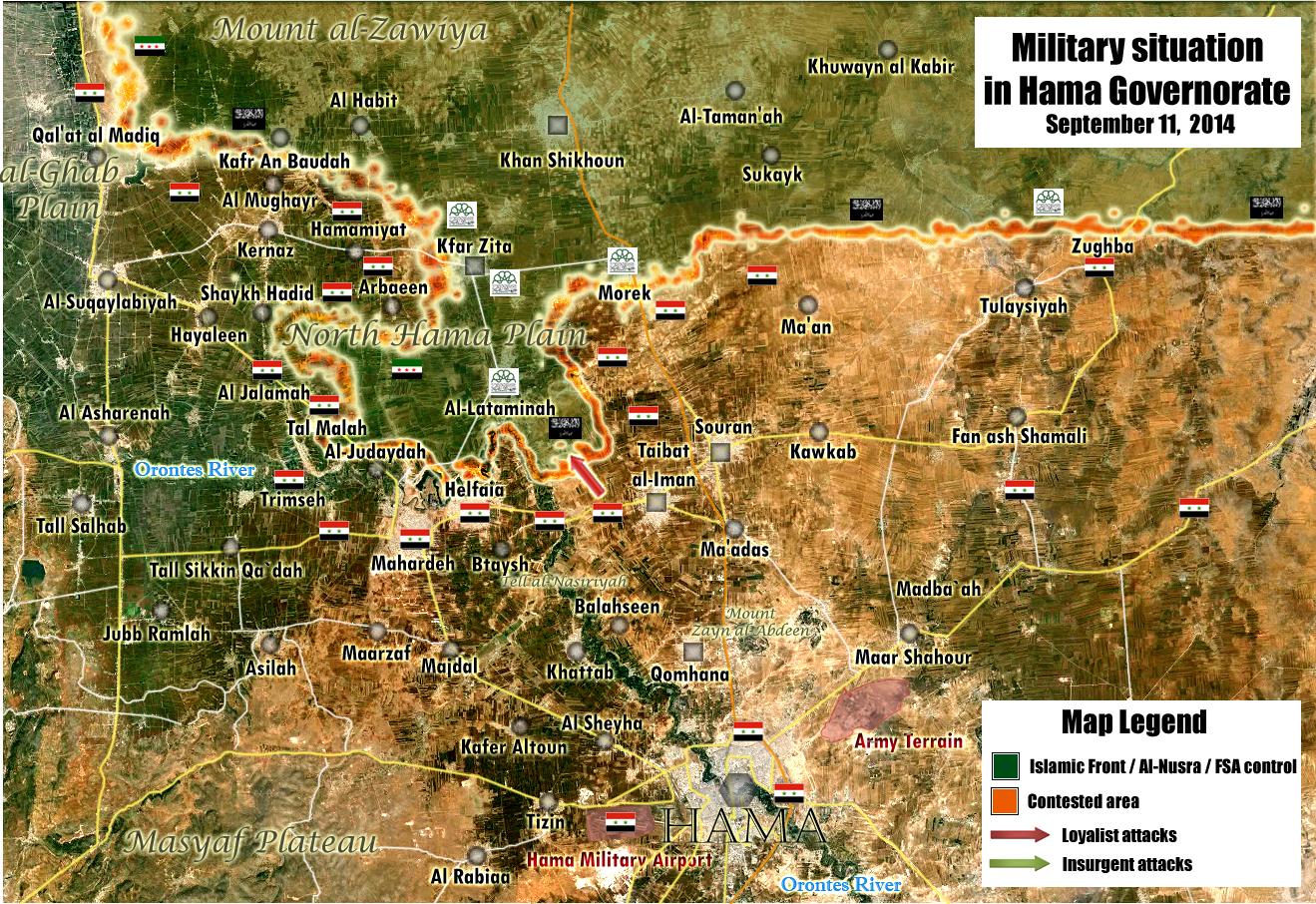
Morek
We still dont clear the situation with the city of Morek because we have a lot of reports from the SOHR which said that clashes still ongoing in the city. But some reliable sources said that the army’s next target appears to be the rebel strongholds of Kfar Zeita and Morek, which are on the highway that links Hama with Aleppo.The Washington PostABC NewsFox News Pro government map also does not give a clear answer about the one who controls the city. Maybe we should mark it to green circle and put around it the red circle. So I ask other editors to express their opinion about this situation. Hanibal911 (talk) 14:48, 12 September 2014 (UTC)
Yeah, I agree with you. Several weeks ago we had SOHR reporting that rebels captured the southeastern part of Morek. Fighting continued "inside the town", but SOHR is notorious for it's use of in/near/around towns. Sometimes they don't seem to master English that well to distinguish between English forms. Green with a red ring or half circle should do for now. — Preceding unsigned comment added by 84.24.43.183 (talk) 16:07, 12 September 2014 (UTC)
- Agreed. Go green with a red circle for the time being, and let's just be diligent to update accordingly when the SAA launches offensive operations against Morek / Kafr Zita area. On the flip side, if the community consensus is to leave it contested, that's valid as well seeing as how Morek is on the front line and we don't have 100% proof one way or the other Boredwhytekid (talk) 17:22, 12 September 2014 (UTC)
- So that guys you are everyone agrees that the city must be to marked the green circle and put red circle around him. So if anybody does not have other data issue has resolved. Hanibal911 (talk) 18:02, 12 September 2014 (UTC)
I do not agree at all. There is no indication that SAA in not present in the city anymore. Lack of news cannot be used to change the status of a city. Back to contested.Paolowalter (talk) 20:44, 12 September 2014 (UTC)
Agree with Paolo. Just a few days ago SOHR reported clashes inside the town. EkoGraf (talk) 19:31, 13 September 2014 (UTC)
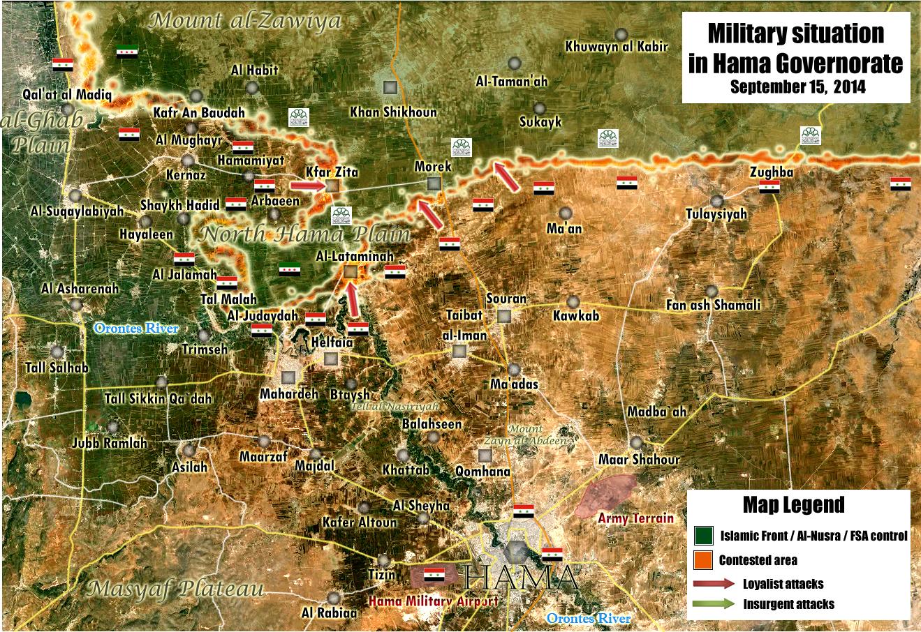
- New version of the pro government map dated 15 September clear show that no clashes in city Morek but showed that now clashes in the cities Kfar Zita and Al Lataminah.here Hanibal911 (talk) 18:55, 15 September 2014 (UTC)
gov source: mork completely under rebel contro, SAA controls southern part of lataminah. no info on kfr zita. — Preceding unsigned comment added by 132.231.183.4 (talk) 07:21, 16 September 2014 (UTC)
Qal'at Al Madiq, Al jalma
This cities is under the control of SAA according to this map.MZarif (talk) 15:02, 12 September 2014 (UTC) http://www.almasdarnews.com/article/updated-map-west-hama-whats-next-syrian-army/#prettyPhoto/0/
Sorry, that's not a valid source. It's a Syrian Perspective map and extremely pro-SAA :) — Preceding unsigned comment added by 84.24.43.183 (talk) 16:05, 12 September 2014 (UTC)
- it is a valid source. Report on both sides losses and gains accurately, just like SOHR. Also, that is not a Syrian Perspective map. They just repost them. — Preceding unsigned comment added by 2602:30A:C01B:89F0:4C1F:A767:8E14:8CED (talk) 19:41, 12 September 2014 (UTC)
- I agree. Maps from Keepingtheleith are very accurate abd have proven to be reliable. More than SOHR actually. We should use them both for pro-rebels and pro-gov changes. Otherwise many places will be frozen for ever in a wrong status given the shortage of good pro-rebels maps.
In particular Qal'at Al Madiq is clearly behind the lines with no sign of fighting, while Al jalma is located in a contested area where many of our information turned out to be wrong. Red is their most likely status now.Paolowalter (talk) 20:44, 12 September 2014 (UTC)
Sorry Paolowalter, but you yourself said: "this map is no place for guesses and own initiatives". So it stays contested until a NEUTRAL or pro-OPP source claims so. Your own argument ... — Preceding unsigned comment added by 84.24.43.183 (talk) 21:37, 12 September 2014 (UTC)
The only rule is "use reliable source". A source is considered reliable based on its track record. These maps and www.almasdarnews.com/ proofed to reliable and objective over several months. If the rule is "no pro-gov for pro-gov changes" and "no pro-rebels for pro-rebels" changes, then SOHR cannot be used. Actually SOHR was accepted after its track record was considered reliable. Those maps and www.almasdarnews.com are at least as reliable.Paolowalter (talk) 22:17, 12 September 2014 (UTC)
You mis the point. This "Almasdar map" is NOT an Almasdar map. It's made by Syrian Perspective, who has an established account of pro-SAA advances and propaganda. Just like we don't use Arab Chronicle of Archicivilians map to show the situation on the ground. This map simply can't be used to make pro-SAA gains, just als pro-OPP maps can't be used to show rebel gains. — Preceding unsigned comment added by 84.31.204.195 (talk) 10:21, 13 September 2014 (UTC)
- I'm on board with .183 and .195 - the map is a republication from syrianperspective, which, just to point out, is essentially the ONLY map considered pro-gov't here. Boredwhytekid (talk) 12:25, 13 September 2014 (UTC)
- I understand the need to lie for supporting your unjustified statements, but these maps are not from syrianperspective!!!!!!! They are produced by a guy Keepingtheleith on twitter.
You have not produced a single argument against their validity. On the other hand, if no pro-OPP maps can be used, not even pro-OPP source can. Therefore we revoke the status of reliable from SOHR. It cannot be used anymore. Finally www.almasdarnews.com produces reliable information and it does not only publish somebdoy else map. I was mentioning those information to be considered reliable. Paolowalter (talk) 14:14, 13 September 2014 (UTC)
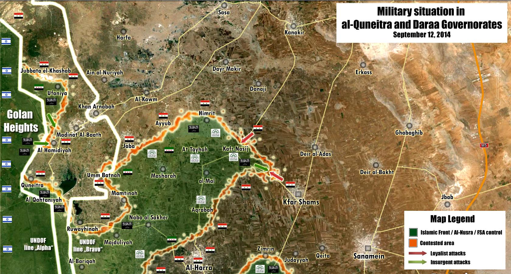
Ayn Aysha
It looks like, and correct me if I'm wrong, Ayn Al Basha is under rebel control according to this pro-government map , the village is located under Majduliye, somewhere near the Islamic Front logo west to Al-Hara. Also I found this rebel video allegedly from inside the city ...DuckZz (talk) 19:38, 12 September 2014 (UTC)
- This is a controversial issue and let us edit only those villages which clear indicated on the map. And pro opposition amateur video from YouTube is not reliable source and also we cant use pro opposition source to display rebel advances. Hanibal911 (talk) 20:02, 12 September 2014 (UTC)
There is more. What about the towns of Rasm al Kharrar and Rasm al Sayd? This pro-SAA map shows Mamtinah as contested, but both villages are south/east of Mamtinah. Should they be made green? — Preceding unsigned comment added by 84.24.43.183 (talk) 20:17, 12 September 2014 (UTC)
- Map clearly do not show this so that maybe be better to mark these villages as contested. Hanibal911 (talk) 20:43, 12 September 2014 (UTC)
Yeah that could be a temporary solution untill there is more news. It's a shame that the Golan region is so isolated yet strategicaly so important. We get little to no neutral sources and a lot of activity on the ground. Nightmare for every Wikipedia editor :) — Preceding unsigned comment added by 84.24.43.183 (talk) 21:28, 12 September 2014 (UTC)
- It is true. Massive amounts of propaganda come from the Quneitra governate, usually in the form of rebel or IDF propaganda. Unfortunately, it is our job to keep this map as accurate as possible and we cannot simply freeze the map in time as a solution. Another problem is that SOHR, a rebel propaganda outlet, essentially has a carte-blanche on wikipedia [it or its quotes are responsible for about 75% of all edits to this map] because editors are unwilling to reconvene and form a new consensus. Until the "smoke clears" around the fighting, all the information we will have about the fighting there will come from SOHR. 2602:30A:C01B:89F0:4C1F:A767:8E14:8CED (talk) 23:55, 12 September 2014 (UTC)
You guys will find any excuse...the rebels have the upper hand in Quneitra. This is a fact. You might not like it, but that's just the way it is. Stop finding excuses for your biased editing. — Preceding unsigned comment added by 37.60.184.15 (talk) 01:23, 13 September 2014 (UTC)
- Biased editing? SOHR, the mouthpiece of the rebels, is responsible for 75% of all edits on here. If anything, this map is biased in favor of the rebels. 2602:30A:C01B:89F0:4C1F:A767:8E14:8CED (talk) 01:36, 13 September 2014 (UTC)
It seems that indeed rebels have taken over large parts of Quneitra, and advanced into northeastern Daraa. There are even reports of the army retreating from areas close to Dayr Makir in southern Rif Damashq. But we don't have sources for that. What supprises me is the seeming ease with which rebels have advanced in two weeks time. As for Rasm al Kharrar and Rasm al Sayd, I think contested would be the best for now, although I personally beleave them to be rebel held. — Preceding unsigned comment added by 84.24.43.183 (talk) 08:04, 13 September 2014 (UTC)
How do you guys feel about changing Al-Ruwayhinah to green? https://www.facebook.com/syriahroe/posts/582287055212970 SOHR reported it to be rebel held. At very least Al-Hamadiyah from this same post was confirmed by Peto Lucem(pro-regime) to be captured by the rebels(who now broke the siege of the Ufaniya and Al-Huriyah villages). Considering that all pro-rebel pages reported the takeover of Al-Ruwayhinah, we can at least search for a pro-regime page about it. — Preceding unsigned comment added by 177.157.18.51 (talk) 20:27, 13 September 2014 (UTC)
Zimrin
Zimrin under saa control: http://www.al-monitor.com/pulse/originals/2014/09/syria-golan-rebels-attack-control-quneitra.htmlHwinsp (talk) 20:03, 12 September 2014 (UTC)
Pro-SAA map of Syrian Perspective showing it as rebel held. I think contested is the best option, since Al-Monitor says SAA forces are massing "in the area of". So maybe not the town, but close by? — Preceding unsigned comment added by 84.24.43.183 (talk) 20:18, 12 September 2014 (UTC)
- This town was marked red few days ago relying on al-monitor article. The map (not by Syrian Perspective, but by Keepingtheleith twitter account) put it on the front line compatible with the article. Therefore it stays red.Paolowalter (talk) 20:44, 12 September 2014 (UTC)
- Yea the al-monitor article is the latest source on Zimrin - SAA controlled Boredwhytekid (talk) 12:18, 13 September 2014 (UTC)
- You are right guys! Now the city of Zimrin under control by army and this confirmed from reliable source. Hanibal911 (talk) 14:48, 13 September 2014 (UTC)
- Also according pro opposition map city Zimrin under control by army.here Hanibal911 (talk) 15:59, 13 September 2014 (UTC)
- You are right guys! Now the city of Zimrin under control by army and this confirmed from reliable source. Hanibal911 (talk) 14:48, 13 September 2014 (UTC)
Kafr Rumah
SOHR reports 3 airstrikes on this city. IS there any SAA presence in this city ? — Preceding unsigned comment added by DuckZz (talk • contribs) 16:28, 13 September 2014 (UTC)
The city as far as i know is divided between the government and the rebels and represents the front line near the base of Hamadiyah.Air strikes are probably targeting rebel lines near or in the rebel part of the village.Daki122 (talk) 18:56, 13 September 2014 (UTC)
- In early June pro opposition source reported that two pro-regime soldiers were reportedly killed while 4 others wounded, during clashes with fighters from the FSA in the town of Kafrouma in Idlib countryside.here Maybe someone else of editors have other information about the situation in the city. Hanibal911 (talk) 19:24, 13 September 2014 (UTC)
IS control in eastern Hama?
What's the sources for all the black Islamic State dots in eastern Hama province and the neighboring part of Homs province? IS having an enclave of control here seems like it should be a big deal, but I haven't heard anything about it. GeoEvan (talk) 16:37, 13 September 2014 (UTC)
- ISIS has an isolated pocket of control in eastern Hama and that has been recognized by multiple maps of the region. They do not advance from there because they are isolated. ISIS also has isolated pockets in Hajar Al-Aswad [Black rock(s)] neighborhood in Damascus, and they do not try to advance from there either. Their lack of advancement is the reason why they get such little reporting. 2602:30A:C01B:89F0:69C3:C978:EC5B:8449 (talk) 17:32, 13 September 2014 (UTC)
- Thanks. Where are the sources on what specific areas are controlled? GeoEvan (talk) 18:14, 13 September 2014 (UTC)
- Sources were put in the edit history and there was a discussion on the talk page here. SOHR (even though pro-opp considered neutral when reporting battlefield events) reported that district, which encompases all those towns, to be ISIS-held. We overlapped that over a map of a slightly pro-opp source and per that made the edit. EkoGraf (talk) 19:27, 13 September 2014 (UTC)
- Thanks. It's sometimes very difficult to track down the sources from the edit history, not knowing exact keywords used in the edit summaries or around what time period it was edited. It would be nice if there was a more easily-accessible record of sources (perhaps arranged by city and governorate), but I understand that you guys are already putting in a lot of hard work. GeoEvan (talk) 07:42, 14 September 2014 (UTC)
- Sources were put in the edit history and there was a discussion on the talk page here. SOHR (even though pro-opp considered neutral when reporting battlefield events) reported that district, which encompases all those towns, to be ISIS-held. We overlapped that over a map of a slightly pro-opp source and per that made the edit. EkoGraf (talk) 19:27, 13 September 2014 (UTC)
- Thanks. Where are the sources on what specific areas are controlled? GeoEvan (talk) 18:14, 13 September 2014 (UTC)
no,the ISIS-held area in Eastern Hama is connected to Raqqa Province and to the Homs Badiyah. Alhanuty (talk) 22:42, 13 September 2014 (UTC)
- No it is not , it is isolated. In order to be linked with Raqqa, ISIS has to control Al-ithryah, which lies on the Hama-Raqqa road, and they do not. 2602:30A:C01B:89F0:69C3:C978:EC5B:8449 (talk) 04:47, 14 September 2014 (UTC)
- Just throwing this on here b/c it's another map showing IS presence stretching into Hama province http://www.businessinsider.com/the-syrian-civil-war-is-on-the-verge-of-getting-even-worse-2014-9 — Preceding unsigned comment added by Boredwhytekid (talk • contribs) 13:52, 15 September 2014 (UTC)
- IP 2602:30A:C01B:89F0:69C3:C978:EC5B:8449 is wrong. An officer on pro-gov TV clearly says @2:25 that ISIS in Hama is “open up to the Iraqi border”. So they are not isolated. Tradediatalk 00:16, 22 September 2014 (UTC)
Al Mahmudiyah
SOHR said that violent clashes took place between YPG fighters and IS fighters in the village of Al Mahmudiyah in the eastern countryside of Ayn al Arab ( Kobani)SOHRHawar News So maybe someone knows something about what the village in question. Hanibal911 (talk) 18:18, 13 September 2014 (UTC)
SAA advances in Hama
SANA and an opposition activist in Hama reported the Syrian troops have captured several towns in Hama province including of Taibet al-Imam, Lweibdah and Zour Abo Zaid. Please find them and add them with red dots. Source here [3]. Thank you. EkoGraf (talk) 19:39, 13 September 2014 (UTC)
- Here confirmation this data from other reliable sources.Denver PostNewsOKThe Modesto BeeCharlotte ObserverDecatur DailyThe Epoch TimesPost StarBNDSun HeraldThe Jordan TimesThe News Tribune Hanibal911 (talk) 20:16, 13 September 2014 (UTC)
Hanibal lol, why do you post those sites if they all wrote "SANA quoted" in their article ? I say we wait for SOHR or a pro-rebel map. — Preceding unsigned comment added by DuckZz (talk • contribs) 22:34, 13 September 2014 (UTC)
- Firstly I not use data not directly from the news agency SANA this information confirm reliable sources and secondly source said that a Hama-based opposition activist who goes by the name of Yazan Shahdawi also confirmed that troops captured the areas in Hama province. So that DuckZz stop making unfounded accusations! Hanibal911 (talk) 07:15, 14 September 2014 (UTC)
I mentioned two weeks ago that the opposition has captured Taybat Al-Emam,but still you refused it and ignored it,next time when SOHR mentions that The Regime is bombing a town in the center,turn the city to Rebel-held.Alhanuty (talk) 22:40, 13 September 2014 (UTC)
- You are partly right but sometimes the army also bombed the town or village in which there are clashes and air force bombed rebel positions that to help army in clashes. Hanibal911 (talk) 07:00, 14 September 2014 (UTC)
- Also source SOHR partly biased in pro opposition side but we agreed use him but announcement that the regime is bombing a town or village not enough that would change it to a contested especially if it's a large city. Hanibal911 (talk) 07:07, 14 September 2014 (UTC)
- In any case, confirmed by pro-opposition activist, add red dots please. EkoGraf (talk) 12:46, 14 September 2014 (UTC)
- Also source SOHR partly biased in pro opposition side but we agreed use him but announcement that the regime is bombing a town or village not enough that would change it to a contested especially if it's a large city. Hanibal911 (talk) 07:07, 14 September 2014 (UTC)
Actualy Taibet-al-Imam was never captured by the opposition it was at most contested because neither SOHR nor did the rebels on the ground reported that.It was a spill over from the nearby offensive which aimed to capture Hama airport.And if someone is bombing the city that does not mean the city held by the other party at max we can make it contested as both sides may have parts of the town under their control and are bombing the other one.Daki122 (talk) 12:52, 14 September 2014 (UTC)
al-Waer
Probably we need change al-Waer residential neighbourhood near Homs under rebel control but in besiege the army because we see that no truce in this area broken because army shelled and bombing this neighbourhood. But not one source nit said that now clashes in this neighbourhood. So I ask other editors to express their opinion about this situation. Hanibal911 (talk) 07:52, 14 September 2014 (UTC)
- I don't think that there will be a truce although it is still possible because fighters in this area are deprived from both food and water due to the siege so rebel control with a red circle around it for the time being until we have more info Roy9955 (talk) 08:27, 14 September 2014 (UTC)
- Area is marked as contested because the SAA controls a part of it since May after they made advances in the district. EkoGraf (talk) 12:55, 14 September 2014 (UTC)
- Maybe you're right! Still, let's listen to other editors. Hanibal911 (talk) 13:04, 14 September 2014 (UTC)
- Area is marked as contested because the SAA controls a part of it since May after they made advances in the district. EkoGraf (talk) 12:55, 14 September 2014 (UTC)
Can we do contested icon and a red circle around it? I think EkoGraf is right - the SAA has entered select parts of al-Waer, but we need to show it besieged as well Boredwhytekid (talk) 14:41, 15 September 2014 (UTC)
- Agree! Hanibal911 (talk) 14:52, 15 September 2014 (UTC)
Regime Enclaves
The siege of Abu l Duhur airbase has not been lifted since we would have read about it either in pro-gov or pro-opp sources so I suggest removing the "Supply Route" the airbase has on the other map. On the other hand I suggest drawing a small supply route to the regime controlled part of Deir l Zor since many pro-regime sources have spoken about reinforcements (Vehicles included) to the Deir l Zor airport. Your thoughts? ChrissCh94 (talk) 09:34, 14 September 2014 (UTC)
Tall Hamis
Documents.sy has reported that YPG Has controlled Tall Hamis (https://www.facebook.com/documents.sy/posts/801761649886593) Roy9955 (talk) 10:04, 14 September 2014 (UTC)
If not to change Tall Hamis yet, at least be true to Tall Brak, which is held by a local tribe, not by IS, as this pro-rebel(enemy to both the Kurds and the IS) map shows:
https://pietervanostaeyen.files.wordpress.com/2014/09/2000px-syria6.png?w=640&h=562 — Preceding unsigned comment added by 177.157.18.51 (talk) 11:31, 14 September 2014 (UTC)
YPG not controlling Tal Hamis yet, but 5 villages north of it:
https://www.facebook.com/syriahroe/posts/582922601816082
Abu Qasayib is one of them and should be changed to yellow.
186.119.179.151 (talk) 16:24, 14 September 2014 (UTC)
- Pro oppositiom Kurdish source clear said that town of Tel Brak under control by IS.Ara News Hanibal911 (talk) 09:23, 15 September 2014 (UTC)
Yes Hanibal911, one source vs the other 1000s of Kurdish sources saying otherwise. But well, mantain it that way, is just a small town, not going to kill anyone — Preceding unsigned comment added by 177.204.42.21 (talk) 21:43, 15 September 2014 (UTC)
Hasakah province
SOHR reported that YPG have taken over the villages of Rahiyeh, Hajiyeh, Kabib and Harikeh, Abu Khazaf and its surrounding farmlands. I found Abu Khazaf but I can not find the rest may be someone knows where these villages.source Ara News Hanibal911 (talk) 09:42, 15 September 2014 (UTC)
There is this map from late December YPG offensive on Tal Hamis which shows all of the mentioned villages:
https://pbs.twimg.com/media/BxdZNSuCAAEAdMS.png
186.119.179.151 (talk) 17:46, 14 September 2014 (UTC)
the problem,is that IS three months ago has seized all the villages up to Tal Marouf and the villages up to Tal Tamer,but the YPG didn't report this,but now the YPG retook those positions,now,the Wikipedi map has became inaccurate,it needs to be more accurate.Alhanuty (talk) 18:43, 14 September 2014 (UTC)
Hama countryside
Apparently SAA took control of the village Al-Zilaqiat northe of Helfaya on their way to Al-Lataminah. Let's look if a neutral source will report it. Paolowalter (talk) 18:51, 14 September 2014 (UTC)
Al Mayadeen TV live report from Hama's eastern countryside in Salamiyah - ISIS
Pro Syrian-gov Al Mayadeen TV channel confirms that ISIS controls Akash, Awademi, Um Meil, Abu Hubaylat. Al Mayadeen TV is going to make a report on the situation in Hama's eastern and western countryside which will be aired on September 18, than we will know more how the situation is on the ground. Link: http://www.almayadeen.net/ar/Newscast/id9YdiSiT0,8cKOgALmBrg/10/2014-09-08
However i followed Facebook pages which belong to pro-gov NDF and youtube videos which confirm that...
ISIS controls the following villages: Ez al-Deen,Tloul al-Hemer, Aydoun, al-Dalak, Soha, Uqayribat, Salam Sharqi, Al-Jawadiyah, Abu al-Hanaya, Qleib and Al-Makfar.
SAA controls the following villages: al-Masudiyah, Berri West and East, Fritan, Tel Dara, Aqarib, Tel Tout, Khneifes and Sneida. — Preceding unsigned comment added by YasminSham88 (talk • contribs) 20:11, 14 September 2014 (UTC)
Hasakah province
For the third time, Tell Brak is considered by this pro-rebel source to be local tribe held, which is consistence with the reports on the time of it's fall, where YPG handed it over to a local tribe.
Also, according to this pro-YPG source: https://twitter.com/r3sho/status/511178350589509632 the IS control the village of Al-Rawiyah west of Serêkaniye(Ras Al-Ayn) — Preceding unsigned comment added by 177.204.42.21 (talk) 20:44, 14 September 2014 (UTC)
- Anyone know which villages are being referred to here: https://www.facebook.com/syriahroe/posts/583303985111277 ? Boredwhytekid (talk) 14:26, 15 September 2014 (UTC)
Rawiyah being left as disputed as well as Til Xenzir is good, they might not be fighting there right now but clashes emerge every week or so as that place is quite an active a frontline between YPG & IS forces.
190.67.248.154 (talk) 15:24, 15 September 2014 (UTC)
- Also pro opposition source reported that Kurdish fighters from People's Protection Units , the official armed wing of the Kurdish Supreme Committee captured the villages Tall Khalil and Hadeyate.World Bulletin But I only found on the map the village Tall Khalil but I not found on the map the village Hadeyate maybe someone from the editors know where located this village. Hanibal911 (talk) 20:09, 15 September 2014 (UTC)
- Many reliable sources confirmed that Kurdish militias capture 14 villages from IS in northern Syria but not said what kind of village.Vancouver DesiFox NewsYahoo NewsIrish Sun abd pro Kurdish sources also did not specify exactly which villages were captured.Firat NewsHawar NewsRudawa Hanibal911 (talk) 11:32, 16 September 2014 (UTC)
- Islamic State fighters seized 16 Kurdish villages west of the predominantly Kurdish city of Ayn al-Arab(Kobani), in a rapid advance in areas near the Turkish border. HaaretzSOHR Hanibal911 (talk) 09:36, 18 September 2014 (UTC)
- Many reliable sources confirmed that Kurdish militias capture 14 villages from IS in northern Syria but not said what kind of village.Vancouver DesiFox NewsYahoo NewsIrish Sun abd pro Kurdish sources also did not specify exactly which villages were captured.Firat NewsHawar NewsRudawa Hanibal911 (talk) 11:32, 16 September 2014 (UTC)
Deir-ez-Zor
According to SOHR the Army has all the crossings over the river in control with the exception of the central one which was bombed and destroyed. Source:[4].Daki122 (talk) 09:54, 15 September 2014 (UTC)
Another source:[5].Daki122 (talk) 12:58, 15 September 2014 (UTC)
- Daily Star quoting SOHR http://www.dailystar.com.lb/News/Middle-East/2014/Sep-15/270734-syrian-army-destroys-isis-controlled-bridge.ashx#axzz3DOXMORdd Boredwhytekid (talk) 14:32, 15 September 2014 (UTC)
Jayrud/Jayroud
- SOHR reports that the air force just bombed part of this town https://www.facebook.com/syriahroe/posts/583301061778236. I do not know of any source that reports a rebel presence in the town since April http://webcache.googleusercontent.com/search?q=cache:1WlVjya8mfMJ:www.middleeasteye.net/news/syria-raid-kills-civilians-while-businessman-announces-candidacy-president-1498124180+&cd=8&hl=en&ct=clnk&gl=us which I think was an asymmetric/hit-and-run attack. Nonetheless - I guess this is good reason to leave Khan abu Shammat and Brigade 559 up, because it seems that there is still some level of rebel activity in the eastern Qalamoun Boredwhytekid (talk) 14:01, 15 September 2014 (UTC)
- I agree with Boredwhytekid. Hanibal911 (talk) 14:54, 15 September 2014 (UTC)
SOHR reports clashes "near" Ain al Nuriyah https://www.facebook.com/syriahroe/posts/583302425111433. Most likely taking place amongst the army encampments between SAA held Ain al Nuriyah and rebel held Ufaniyah, seen here here. Just something to keep an eye on Boredwhytekid (talk) 15:04, 15 September 2014 (UTC)
Still clashes near Ain al Nuriyah https://www.facebook.com/syriahroe/posts/583661818408827 Boredwhytekid (talk) 12:29, 16 September 2014 (UTC)
And https://www.facebook.com/syriahroe/posts/583529065088769 Boredwhytekid (talk) 12:56, 16 September 2014 (UTC)
Rural Hama map for updates
Peto Lucem Map is Anti Beheader map but quality is very good is always 95% right https://pbs.twimg.com/media/BxlnO9MCMAAvb57.jpg:large — Preceding unsigned comment added by 201.210.251.99 (talk) 20:00, 15 September 2014 (UTC)
- This is ture, Peto's maps are very high quality and accurate, but what are you suggesting. Should we put red rings around Latamenah and Kfar Zeta? 2602:30A:C01B:89F0:1910:8A37:B370:889B (talk) 21:31, 15 September 2014 (UTC)
It looks like the triangle (Latamenah, Kfar Zeta and Morek) are contested but I think we should wait for more sources Roy9955 (talk) 22:26, 15 September 2014 (UTC)
According to this map Jalma is under SAA control, not even contested. — Preceding unsigned comment added by 89.132.127.250 (talk) 09:36, 16 September 2014 (UTC)
Western Damascus
video news from Quneitra: http://www.aljazeera.com/news/middleeast/2014/09/syria-rebels-advance-near-golan-heights-2014915231059492134.html
It says rebels broke the siege of towns northwest of Hamadiyah, including Jubata al Khassab, Turnajah and Beit Jinn. This video report is from after the alledged rebel retreat from western Damascus. Sources on Twitter reported a week ago that this area was in effect the area around Dayr Makir and Kanaker. So, according to this source with images from the region, rebels control Jubata al Khassab, Turnajah and Beit Jinn areas in Quneitra/Western Damascus.
It also says: "Hamidiyah is important because it opens a corridor to the northern countryside already under rebel control". It says rebels also took control of the towns:
- Jubata
- Ufaniyah
Another source claiming the Israeli border is now under near total rebel control: http://www.timesofisrael.com/syrian-rebels-said-to-control-most-of-israel-border/
So: Jubata al Khassab, Turnajah and Beit Jinn to green. I don't know about Mazraat Beit Jen, because they speak of the "Beit Jinn area" in the video. Maybe contested? — Preceding unsigned comment added by 84.24.43.183 (talk) 08:24, 16 September 2014 (UTC)
- Firstly your sources do not say that about the villages Turnajah and Beit Jinn. And SOHR clear said that rebel fighters have pulled back from the western countryside of Damascus into the northern countryside of Daraa, after Jabhat al-Nusra and Islamic battalions have taken over Kafar Nasej, al-Taiha, Aqraba, and Tal al-Mal, between Reef Dimashq and Quneitra.here Also opposition activist said that rebels retreated from three villages Himrit, Maas, Sabsaba) after controlling them for 1 day only.here So stop inventing and distorting the facts. Hanibal911 (talk) 09:39, 16 September 2014 (UTC)
- Also here pro opposition map clear show that village Jubata al Khassab under control by army. Hanibal911 (talk) 09:43, 16 September 2014 (UTC)
I think that changing Beit Jinn to red was a rushed decision. It wasn't clear from where the rebels have retreated from. Why not to wait with Beit Jinn area as green until the situation becomes more clear? — Preceding unsigned comment added by 177.204.42.21 (talk) 10:06, 16 September 2014 (UTC)
- I noted the villages Turnajah and Jubata al-Khashab ubder control by rebels according data from Al Jazeera here but source not said about city Beit Jinn from which previously rebels retreated. Hanibal911 (talk) 10:24, 16 September 2014 (UTC)
Well that's the question, you know. Western Damascus is large. This is a neutral source claiming the Beit Jinn area under rebel control. As I said, Himrit and Maas are not even near Beit Jinn. So, how would rebels have been able to retreat from there of areas like Sasa and Kanaker were still SAA held? I think we have made a mistake in Beit Jinn ... this video report certainly says so. — Preceding unsigned comment added by 84.24.43.183 (talk) 15:11, 16 September 2014 (UTC)
- But the problem is that this source not said about the city Beit Jinn. Hanibal911 (talk) 15:28, 16 September 2014 (UTC)
- Here is a report posted a day after SOHR reported rebels' retreated - it states that Beit Jinn is rebel held and besieged by the SAA Boredwhytekid (talk) 15:44, 16 September 2014 (UTC)
 Done I noted the city Beit Jinn under control by rebels but in besiege Syrian troops. Hanibal911 (talk) 16:07, 16 September 2014 (UTC)
If you did, someone vandalised it back to red. So change it to green(besieged) again. — Preceding unsigned comment added by 177.204.42.21 (talk) 17:12, 16 September 2014 (UTC)
Tell Malh And Jalama
Saa recapture tell malh and jalama :https://www.facebook.com/documents.sy/posts/802732783122813Hwinsp (talk) 10:53, 16 September 2014 (UTC)
pro opp confirmed too: https://twitter.com/markito0171/status/511839471818792964Hwinsp (talk) 12:35, 16 September 2014 (UTC)
So a SANA source + random "pro-opp" guy on twitter was enough for this change. Let's keep what happened in this section (one among many that goes ignored) fresh in our minds the next time a pro-rebel change is being challenged for not enough sources. — Preceding unsigned comment added by 85.112.86.39 (talk) 13:23, 16 September 2014 (UTC)
First document sy is not a sana source and document sy more trustable than sohr and document sy is not pro saa source.Second , i gave this pro opp twitter source because some editors say' we need to wait pro opp source to confirmed it'.So please stfu and stop crying.ThanksHwinsp (talk) 13:33, 16 September 2014 (UTC)
- Yea, user "Mark" is obviously an authoritative twitter source (sic) lol. I agree with the edit - in all probability the SAA overran this area. But, I agree with user .86.39 too - using "Mark" as the rebel source is really reaching. Also, please refrain from profane phrase like "stfu" as it violates wiki policy. Boredwhytekid (talk) 13:58, 16 September 2014 (UTC)
I say stfu because he says document sy is a sana source.Document sy. is pro opp source and shares tow videos and makes rebel propaganda.Look at this document sy videos: https://www.facebook.com/documents.sy/videosHwinsp (talk) 14:09, 16 September 2014 (UTC)
- I get that, but Wikipedia says, don't say "stfu" - so, please keep disagree civilly and avoid cursing. Boredwhytekid (talk) 14:22, 16 September 2014 (UTC)
- Anonymous editor using IP 85.112.86.39 address if you look at the history of editing, you will see that that village Tall Malah was previously marked under the control of the army. Hanibal911 (talk) 14:18, 16 September 2014 (UTC)
- I Agree with Boredwhytekid! Hanibal911 (talk) 14:25, 16 September 2014 (UTC)
- Also I agree with Hwinsp that Document.sy it is biased pro opposition source. Hanibal911 (talk) 14:29, 16 September 2014 (UTC)
- Also here another confirmation from pro opposition source that rebels lost villages Jalma and TallMelh.Archicivilians Hanibal911 (talk) 14:35, 16 September 2014 (UTC)
- Also I agree with Hwinsp that Document.sy it is biased pro opposition source. Hanibal911 (talk) 14:29, 16 September 2014 (UTC)
- I Agree with Boredwhytekid! Hanibal911 (talk) 14:25, 16 September 2014 (UTC)
I am sorry to say stfu but 85.112.86.39 should stop lyingHwinsp (talk) 16:07, 16 September 2014 (UTC)
- SOHR also confirmed that Syrian troops recaptured the villages Tell Malh and Jalama.SOHR Hanibal911 (talk) 19:57, 16 September 2014 (UTC)
Syrian army captures several areas in Hama province - 16/09/2014
SANA (in arabic), opposition websites and other media outlets confirm that Syrian army captured Al-Jedideh, Jalma, Tell Malh, Kafr Hood and Tremseh today. YasminSham88 (talk) 14:23, 16 September 2014 (UTC)
- Provide/link pro-op or neutral sources to validate SAA advances and the appropriate edits will be made. Boredwhytekid (talk) 14:27, 16 September 2014 (UTC)
- Pro opposition map clear show that the city Tremseh under control by army.here Hanibal911 (talk) 14:30, 16 September 2014 (UTC)
- Tremseh is already on our map and red Boredwhytekid (talk) 14:37, 16 September 2014 (UTC)
- I know just stating a fact. Hanibal911 (talk) 14:43, 16 September 2014 (UTC)
- gotcha :) Boredwhytekid (talk) 14:46, 16 September 2014 (UTC)
- Also army recaptured the towns Jadidah and Zallaqiyat and now the Syrian troops are at the outskirts of the town of Al Lataminah.Global Post Hanibal911 (talk) 16:36, 16 September 2014 (UTC)
SANA is very a credible source. --Pototo1 (talk) 00:56, 17 September 2014 (UTC)
Hama Map Mistakes - Northern Hama province
The opposition controls: Al-Arbaeen, Hamamiyat and Al-Buwayda. YasminSham88 (talk) 14:49, 16 September 2014 (UTC)
- Source? Hanibal911 (talk) 14:52, 16 September 2014 (UTC)
- SOHR reports that the regular forces raided houses in al-Arba'en and al-Hseinat, reports of detaining many civilians. This confirms the fact that the village al-Arba'en under army control.SOHR Also pro opposition map show that area to west from city Kfar Zita where located the village Hamamiyat now under control by troops.here Also remember that in the future before you post information on the talk page you need find a source that can confirm all your data. Hanibal911 (talk) 15:07, 16 September 2014 (UTC)
LOL yasmin that is where SAA is attacking Kfar zita from. Don't be silly. snackbar. — Preceding unsigned comment added by 89.132.127.250 (talk) 19:16, 16 September 2014 (UTC)
Hello, can you create a map showing the situation in Hama province ? 78.214.63.247 (talk) 21:28, 17 September 2014 (UTC)
Flita, Qalamoun
SOHR still reporting clashes in the Qalamoun wastelands here. No need for adding additional green presence around Flita, because this action took place in the wilderness - I'm just posting this as an up-to-date justifier for the green circle to the northwest of Ras al Maara Boredwhytekid (talk) 15:00, 16 September 2014 (UTC)
- Here's more information about the situation in the area. Al Nusra Front fighters hit in ambushed the Syrian army in the Qalamoun border region of Flita, some 7 kilometers from the border with Lebanon, shortly before midnight and retreat to the border where they clashed with the Lebanese Army.The Daily Star Hanibal911 (talk) 15:18, 16 September 2014 (UTC)
SAA capture Gweran neighborhood (Hasakah)
sohr says saa capture gweran neighborhood (Hasakah) https://www.facebook.com/syriahroe/posts/583889075052768 Hwinsp (talk) 07:02, 17 September 2014 (UTC)
another source: https://www.facebook.com/documents.sy/posts/803185179744240 please fix hasakah map https://commons.wikimedia.org/wiki/File:Battle_of_Hasakah.svg Hwinsp (talk) 10:34, 17 September 2014 (UTC)
Tell Malh And Al Zalaqiat
Nusra recapture tell malh and al zalaqiat according to sohr : https://www.facebook.com/syriahroe/posts/584006361707706Hwinsp (talk) 08:30, 17 September 2014 (UTC)
- : Done Hanibal911 (talk) 08:50, 17 September 2014 (UTC)
SOHR is not a reliable source for rebel advances, please find other pro-gov sources or neutral sources, otherwise put those villages in red again. — Preceding unsigned comment added by Lessi94 (talk • contribs) 10:15, 17 September 2014 (UTC)
Actually SOHR is the only opposition source we acknowledge when it comes to rebel advances because they have been shown to be 95 percent correct and are considered an authoritative sources by neutral sources that also use SOHR such as AFP, Reuters etc.
This is completely wrong !!! SOHR is just the rebel equivalent of SANA. If we follow this logic, all the SANA reports about SAA advances and rebel losses are true. lol. — Preceding unsigned comment added by 82.233.227.191 (talk) 18:56, 17 September 2014 (UTC)
- The rebel equivalent of SANA? lol. SANA has not reported a single rebel advance in 3+ years. Not a single one. SOHR is pro-op, but reports both advances and loses for the SAA, FSA, IF, IS, YPG, etc.. Though I don't know why I typed this. It's self-evident. Boredwhytekid (talk) 19:22, 17 September 2014 (UTC)
- Despite the fact that SOHR is blatantly pro-opp., we are willing to ignore that because of an old consensus established that somehow determined that SOHR was reliable anyway and no one is willing to revise or remove this consensus. Interestingly enough, SOHR Facebook posts are prohibited by that consensus, so technically, SOHR website is "reliable" while their Facebook page is "unreliable".2602:30A:C01B:89F0:4C1F:A767:8E14:8CED (talk) 19:54, 17 September 2014 (UTC)
Raqqa province
Here new pro opposition map which show IS advance in Tall Abyad countryside in the north eastern part of the Raqqa province. Hanibal911 (talk) 17:38, 17 September 2014 (UTC)
I think we need pro YPG sources to clarify the situation. — Preceding unsigned comment added by Lessi94 (talk • contribs) 19:02, 17 September 2014 (UTC)
This pro-YPG source lists a number of villages that have been taken over by ISIS in the last few days. http://www.alkurdiya.net/2014/09/blog-post_231.html Dulldul (talk) — Preceding undated comment added 20:07, 17 September 2014 (UTC)
IS have taken over 21 villages inhabited by Kurdish civilians, in the western and eastern countrysides of Ein al-Arab "Kobane". But they do not specify which ones. https://www.facebook.com/syriahroe/posts/584403375001338 — Preceding unsigned comment added by 77.240.103.2 (talk) 10:52, 18 September 2014 (UTC)
- Here are maps that show how advances the IS insurgents offensive in the area city Ayn Al Arab (Kobani). herehere Hanibal911 (talk) 11:24, 18 September 2014 (UTC)
As-Suhknah
As-Suhknah (Near Palmyra) has suddenly turned black. Any reliable source about that? Kihtnu (talk) 07:13, 18 September 2014 (UTC)
- I corrected this mistake city under control by Syrian army. This also confirmed pro opposition source here And not one of the reliable sources not said that the city is under the control of IS. Hanibal911 (talk) 08:01, 18 September 2014 (UTC)
Saa recapture Tell Malh area
saa recapture tell malh source : http://www.syriahr.com/index.php?option=com_news&nid=23669&Itemid=2&task=displaynewsHwinsp (talk) 10:43, 18 September 2014 (UTC)
- This also confirmed pro opposition source.archicivilians Hanibal911 (talk) 11:31, 18 September 2014 (UTC)
Kobane
Many of the edits from this reference have already been made - thanks Hanibal - but let's keep an eye open for any other specific towns being named. Boredwhytekid (talk) 12:15, 18 September 2014 (UTC)
daily star the guardian Boredwhytekid (talk) 12:39, 18 September 2014 (UTC)
Qlib al Thour, Hama
SOHR reports airstrikes on this front-line town in eastern Hama. Please change from red, to black (or at least contested) Boredwhytekid (talk) 15:48, 18 September 2014 (UTC)
- Done I noted this village as contested because the source does not specify who controls it. Hanibal911 (talk) 16:08, 18 September 2014 (UTC)
- Thank you! Boredwhytekid (talk) 16:18, 18 September 2014 (UTC)
A Green dot in Deir Ez-Zor and a SAA base in Hasakah
Sources for both? The Subaykhan village in Deir Ez-Zor, while the area is unfortunetly all Islamic State held according to basically all sources. And that Hajanah Batallion deep inside Kurdish territory in Hasakah province? Either give a good source or exclude both of them. — Preceding unsigned comment added by 189.26.154.7 (talk) 17:43, 18 September 2014 (UTC)
- Hajanah Batallion located on area in the territory Rumeilan oil field which still under control of the YPG and pro-regime forces. This data confirm pro opposition Kurdish source. here
- Subaikhan it is the rebel-held town in the eastern province of Deir al-Zour.Shanghai Daily Hanibal911 (talk) 18:26, 18 September 2014 (UTC)
I think Shangai Daily is misquoting. The SOHR report from that date says the airstrikes were made "under the pretext of targeting IS posts" - pretty much saying that the air force ended up killing some civilians when they were bombing an IS held town Boredwhytekid (talk) 18:52, 18 September 2014 (UTC)
Agree with Bored, its a misquote. Whole area is ISIS-held. EkoGraf (talk) 10:40, 19 September 2014 (UTC)
The aranews source doesn't really warrant putting a whole battalion under SAA control in the middle of a territory where their presence was previously unknown, specially since they don't even confirm the base to be held by them but only say "an pro-regime forces in the area", it's too unspecific to make such a change without further sources.
190.67.144.104 (talk) 17:17, 19 September 2014 (UTC)
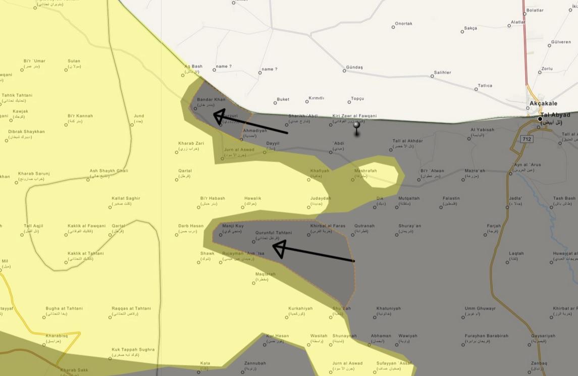
ISIS terrorists captured more than 20 villages in Kobane - Names of Villages and their location
East of Kobane: Korek, Shawek, Menjuk, Bir Arab, Juran, Zurzuri, Kultib, Bir Hish, Khan, Zer, Qartal, Qarfel, Kublek, Qazali, Sarunj, Darb Hassan.
West of Kobane: Talik, Zarik, Turman, Ziyaret, Ashma, Jibnah.
South of Kobane: Belek, Qalhida, Qararishek. source YasminSham88 (talk) 02:26, 19 September 2014 (UTC)
- Additional Sources:
- Todays Zaman (18.09.2014, ENG): "ISIL fighters ... after seizing 21 villages..."
- Todays Zaman (18.09.2014, ENG): ISIL seizes 16 Kurdish villages in Syria, prompting new refugee inflow Civil population of these 16 villages is in Turkey's border.
- Veooz (18.09.2014, ENG): ISIS seizes 21 Syrian villages in just 24 hours as terrified Kurds flee homes to avoid ‘massacres’
- CNN (19.09.2014, ENG): Isis killed hundreds of Kurdish civilians in Til Hemis village in Syria "..activists reported a mass exodus of civilians from the neighboring villages of Kaalak, Zark Qumshi, Zalkhek, and Turaman.."
- CNN (19.09.2014, ENG) ISIS advanced its grip on portions of Syria and Iraq, seizing 16 predominantly Kurdish villages near the Turkish border.
Alexyflemming (talk) 09:47, 19 September 2014 (UTC)
Some tweets indicate, that Kurds lost completely the access to Euphrates river. Of cause, it is not reliable source, but keep an eye on that area.11:31, 19 September 2014 (UTC)82.100.1.6 (talk)
- Alexyflemming Where did you find the names of the towns? And do you know the locations of those that are not on the map already? Boredwhytekid (talk) 15:48, 19 September 2014 (UTC)
- Syrian Kurd forces withdraw from around 60 villages.The Daily Star Hanibal911 (talk) 17:41, 19 September 2014 (UTC)
English SOHR post Boredwhytekid (talk) 20:03, 19 September 2014 (UTC)
Hama province
SAA capture abu raidi and hasara according to sohr: http://www.syriahr.com/index.php?option=com_news&nid=23718&Itemid=2&task=displaynews location abu raidi:http://wikimapia.org/#lang=tr&lat=35.331302&lon=36.571941&z=14&m=b&gz=0;365391540;353191171;0;214272;139045;0;314140;78433;121879;261531;12016;178214 location hasara : http://wikimapia.org/#lang=tr&lat=35.349593&lon=36.526279&z=15&m=b&gz=0;365208721;353398093;0;76312;117588;0;232601;81213;8583;73512 And i think jubbayn should redHwinsp (talk) 14:41, 19 September 2014 (UTC)Hwinsp (talk) 14:17, 19 September 2014 (UTC)
- Here this report from SOHR in english.SOHR Hanibal911 (talk) 14:58, 19 September 2014 (UTC)
- Maybe you're right and we should note the village Jubbayn under army control. Hanibal911 (talk) 15:15, 19 September 2014 (UTC)
- So I think that after army captured villages Abu Raidh and Hasariyah and now troops located on outskirt of city Kafr Zita no sense put the village Jubbayn as a contested because rebels left this area. Hanibal911 (talk) 07:52, 20 September 2014 (UTC)
- Maybe you're right and we should note the village Jubbayn under army control. Hanibal911 (talk) 15:15, 19 September 2014 (UTC)
I agree with hannibal. + saa inside jubbayn : http://www.youtube.com/watch?v=sgp_No-ljcM&feature=youtu.beHwinsp (talk) 13:22, 20 September 2014 (UTC)
Actually it is only today that Jubbayn was taken by SAA: https://twitter.com/SyrianLion_/status/513401169063190529/photo/1. Paolowalter (talk) 20:41, 20 September 2014 (UTC)
Xerabnas
Clashes are taking place in this town near Ayn al Arab. https://twitter.com/isabelhunter/status/512932750178136064 Dulldul (talk) 14:22, 19 September 2014 (UTC)
Regime battalion near al Madaabah
What was the source used to put a regime controlled battalion so deep into kurdish controlled territories? Regime only has presence in/south of Qamishlo and in/south/east of Hasakah.
190.67.144.104 (talk) 16:26, 19 September 2014 (UTC)
- You need carefully closely looked because all clearly described in this section A Green dot in Deir Ez-Zor and a SAA base in Hasakah So before you write messages with questions need a close look at the talk page can someone already post here all the information on the subject. Regards! Hanibal911 (talk) 17:04, 19 September 2014 (UTC)
I had ctrl-f'd the page with some keywords but didn't figure that a simple Hasakah would do, many thanks :)
190.67.144.104 (talk) 17:18, 19 September 2014 (UTC)
Hasaka
From http://www.almasdarnews.com/article/syrian-army-captures-strategic-area-isis-militants-al-hasakah/ a lot of infos about the situation in Hasaka. We could try to turn into useful information for the map.Paolowalter (talk) 19:34, 19 September 2014 (UTC)
Hama and Lataminah
From http://www.almasdarnews.com/article/fierce-clashes-west-hama-result-heavy-losses-2-nusra-emirs-killed/ news about SAA presence in the outskirt of Kafr Zita and Morek. SAA should also be present on the outskirt of Al-Lataminah. — Preceding unsigned comment added by Paolowalter (talk • contribs) 19:38, 19 September 2014 (UTC)
- Al Masdar news is rather pro-government and I would be very careful about any changes, but it can be true, SAA gained a village today, which is just 5 km distant from Kafr Zita and Al-Lataminah. Maybe you could add red ring around these cities or just partly from western side. Or let's wait for some other confirmation...77.240.103.2 (talk) 20:43, 19 September 2014 (UTC)
- I agree, we should add red rings around both cities and wait for further conformation before making them contested. 2602:30A:C01B:89F0:44BE:6E96:8239:5004 (talk) 01:55, 20 September 2014 (UTC)
See also http://the-levant.com/fierce-clashes-west-hama-result-heavy-losses-2-nusra-emirs-killed/ Paolowalter (talk) 21:21, 19 September 2014 (UTC)
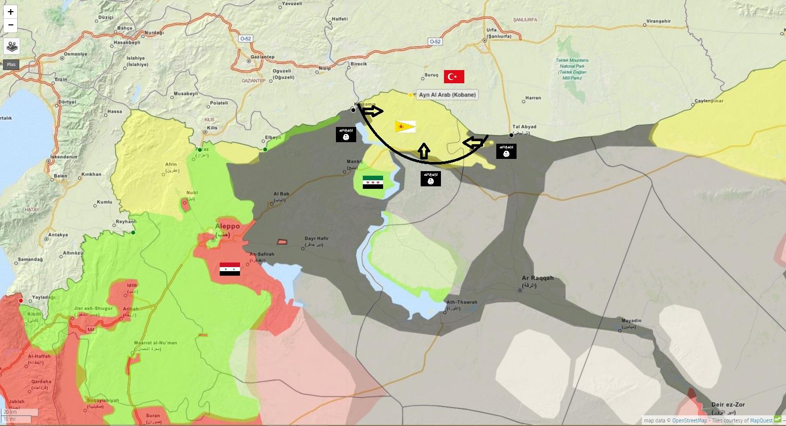
Kobane / Ayn al-Arab
Seeking community opinion on proposal:
- Let's add some more of the known-to-be-Kurdish/YPG-held towns. #1, right now it looks like the Kurds have nada but Kobane proper and a dozen scattered towns. #2, we'll get a step ahead of the game, because more towns in this area are bound to be in the news soon. #3, adding a handful more yellow towns would clarify the front line and true areas of control in this region.
- Offhand, I propose adding the following - Dikmatash Salib Ayn al-Batt Kabbajq small Kabbajq large Qurmza
Other editors - what say you? Boredwhytekid (talk) 19:52, 19 September 2014 (UTC)
Agreed. Alhanuty (talk) 20:34, 19 September 2014 (UTC)
- I agree too, and some villages which we are not sure, who control them, could be shown as contested in this area.77.240.103.2 (talk) 20:45, 19 September 2014 (UTC)
Hanibal911? EkoGraf? Boredwhytekid (talk) 20:48, 19 September 2014 (UTC)
- Contested mean "fighting" ongoing in the town. It does not mean "We don't know".
- For the towns quoted no sources are mentioned. If there are sources, fine, otherwise no.Paolowalter (talk) 21:01, 19 September 2014 (UTC)
An hour ago I would agree with you Bored. However, I think we shouldn't rush it because I just read a source [6] where SOHR confirmed ISIS captured another 39 villages today, making a total of 60 now in the last three days. So in essence, we have no idea where the frontline is at the moment other than a report by the Kobane Kurdish commander saying ISIS is within 20 km from the city. P.S. I would ask all editors to try and find out the names of these 39 new villages. Thank you! EkoGraf (talk) 22:03, 19 September 2014 (UTC)
that looks to be impossible EkoGrak,too much,but looks the Battle for Ain Al-Arab(Kobani) isn't far away,unless the US Airforce strikes sooner,France 24 reported that IS fighters reached the Western Neighborhood of the city.Alhanuty (talk) 22:15, 19 September 2014 (UTC)
- I also agree with the EkoGraf and Boredwhytekid. Hanibal911 (talk) 07:38, 20 September 2014 (UTC)
New map (not proposing any changes here, just found this and thought you would like to have it): https://twitter.com/abuaminah_/status/513243576667353088/photo/1--Andylee Sato (talk) 08:47, 20 September 2014 (UTC)
- SOHR reported that violent clashes have erupted between IS and YPG in the village of Qarah Mog.SOHR Who knows where located this village? Hanibal911 (talk) 09:16, 20 September 2014 (UTC)
- ISIS fighters armed with rockets, artillery, tanks and armored vehicles seized from the Iraqi army in Mosul had advanced to within 20 km of Kobani.The Daily Star Hanibal911 (talk) 09:49, 20 September 2014 (UTC)
- SOHR reported that violent clashes have erupted between IS and YPG in the village of Qarah Mog.SOHR Who knows where located this village? Hanibal911 (talk) 09:16, 20 September 2014 (UTC)
- New map of Kobane area. I don't think we get anything better now. What do you think? https://docs.google.com/file/d/0ByQl9HGZDeRXUXZJdkxfMDhTNTg/edit 77.240.103.2 (talk) 10:56, 20 September 2014 (UTC)
Between the report that IS is within 20mi of Kobane, and the desyracuse map, we should be able to roughly approximate which towns are still Kurdish held no? The ones within 10mi of Kobane can be added with confidence
Ain al-Hand Mahmoud KolmdQurmza Kurabi Bani Saba
It's just that the map at present isn't an accurate representation - we pretty much show the Kurds pushed all the way back to Kobane already, when all reports indicate they have a 15-20mi buffer still I'm on board with using https://docs.google.com/file/d/0ByQl9HGZDeRXUXZJdkxfMDhTNTg/edit in this instance tooBoredwhytekid (talk) 15:12, 20 September 2014 (UTC)
Reuters report - They are not within 15 kilometers from the city. EkoGraf (talk) 15:34, 20 September 2014 (UTC)
- Also IS took control of the village of Qara Moog, Bobby Hill and the village Ghareeb (20 km east of Kobane).Ara News I add the village Gharib but I dont know where located village Qara Moog(Qarah Mog) Hanibal911 (talk) 16:55, 20 September 2014 (UTC)
IS shelling areas 10mi from Kobane SOHR Boredwhytekid (talk) 18:47, 20 September 2014 (UTC)
- ISIS fighters located on distance just in 10 kilometers of the strategic border town known as Ain al-Arab(Kobane).The Daily Star Hanibal911 (talk) 11:10, 21 September 2014 (UTC)
Can someone locate the link of Kobane above the Kobane dot, its making it impossible to read some of the village names under it. 24.12.202.163 (talk) 16:17, 24 September 2014 (UTC)
Tall Ghazal has fallen- https://news.vice.com/article/kobane-residents-remain-defiant-as-islamic-state-closes-in In addition many twitter activists are placing IS a kilometer outside of Kobane from both YPG and IS twitter feeds, so I think we should list Kurdish Villages not yet fallen as encircled and besieged/captured as more info comes in. 173.209.212.195 (talk) 11:02, 25 September 2014 (UTC)
http://s04.justpaste.it/pdf/EanArab1-justpaste-it.pdf Official IS proclamation of captures. Tal Ghazal is captured.Tgoll774 (talk) 12:00, 26 September 2014 (UTC)
Daraa Map
Map is from Around 1-7 to September situation is basically the same http://files.abovetopsecret.com/files/img/td540b68c5.jpg — Preceding unsigned comment added by Pototo1 (talk • contribs) 05:24, 20 September 2014 (UTC)
New updadted on Jobar on front of damascus
September 19 https://twitter.com/PetoLucem/status/513035203799818241/photo/1
There is September 3 (Similar Who we are using now) https://twitter.com/PetoLucem/status/507207133772128256/photo/1 --Pototo1 (talk) 05:37, 20 September 2014 (UTC)
Pro-regime source. We used it only to change an area that was all contested to a green area, but we cannot use it to show a regime advances(specially since neither SOHR nor any other sources claim any regime advances in Jobar area) — Preceding unsigned comment added by 179.177.193.133 (talk) 10:22, 20 September 2014 (UTC)
Peto Lucem Maps are a very credible. — Preceding unsigned comment added by 190.203.137.14 (talk) 16:36, 20 September 2014 (UTC)
A part of the northeastern section of Jobar known as the Taiba area has been confirmed by both sides to be SAA-held. Government source [7] and for the opposition source google FALL OF JOBAR 'WOULD SET US BACK TWO YEARS' (can not link it here because syria direct is black-listed by Wikipedia). So that sliver needs to be red. Also, pro-opposition source [8] confirmed Abadeh is SAA-held, frontline is just west of the town. EkoGraf (talk) 18:44, 20 September 2014 (UTC)
![[8]](https://pbs.twimg.com/media/Bx-lvNnCcAAu5Re.jpg:large)
sohr arabic confirmed flita tower(biggest tower in jobar) under saa control 2-3 days ago(source: http://www.syriahr.com/index.php?option=com_news&nid=23666&Itemid=2&task=displaynews ).But i didnt see this news in sohr eng.Sohr eng doesnt translate about jobar.Hwinsp (talk) 19:18, 20 September 2014 (UTC)
- Confirmed by Al-Masdar: http://www.almasdarnews.com/article/syrian-army-makes-strategic-gain-jobar-fighting-around-east-ghouta/ 2602:30A:C01B:89F0:44BE:6E96:8239:5004 (talk) 19:26, 20 September 2014 (UTC)
Kafr Shams
SOHR reports the air force is bombing at least parts of Kafr Shams, Daraa Boredwhytekid (talk) 18:45, 20 September 2014 (UTC)
- At the moment, it is not enough that would change it to the contested but we need to closely monitor the situation in the city. Hanibal911 (talk) 18:55, 20 September 2014 (UTC)
Agreed Boredwhytekid (talk) 19:02, 20 September 2014 (UTC)
I think it should be changed to contested the situation is unknown, also put a green ring around khirbet ghazala,there was clashes occuring near by it,
also there is a rebel-held zone in the western ghouta near Kiswa and A Pro-government analyst pointed it out via https://twitter.com/PetoLucem/status/513382288479256576
also there has been many SOHR reports of Air-raids on Dirkhabiyah, Zakyah, Mukaylibah, Al-Taybah, there was also may SOHR reports about clashes near Kiswah western frontier , and it is not good to keep towns under government control, if the government shells those cities.Alhanuty (talk) 19:48, 20 September 2014 (UTC)
- We put green or red ring only if the city or villages is besieged! Hanibal911 (talk) 20:05, 20 September 2014 (UTC)
- My gut agrees with you Alhanuty. But, let's just keep an eye on them - if the air force is truly bombing Kafr Shams, more reports will follow, and perhaps even reports of clashes on the ground, since Kafr Shams will then be the front line. What are the sources for Dirkhabiyah, Zakyah, Mukaylibah, Al-Taybah? Boredwhytekid (talk) 20:09, 20 September 2014 (UTC)
- I agree with Boredwhytekid because of 13 september two pro opposition sources clear show that the city Kafr Shams under control by army here and here And there were no more reports about clashes in this city or that he was captured by the rebels. So I think that the one report about air strike on the city is not enough to change the city for the contested. Also you must provide reports from SOHR which confirm your data. Because about villages Dirkhabiyah, Zakyah, Mukaylibah, Al-Taybah only pro opposition source said that they under control by rebels.here and here Hanibal911 (talk) 20:29, 20 September 2014 (UTC)
A Pro-government source posted a map of it confirming the opposition presense,https://twitter.com/PetoLucem/status/513382288479256576.Alhanuty (talk) 22:31, 20 September 2014 (UTC) https://www.facebook.com/syriahroe/posts/583846421723700 https://www.facebook.com/syriahroe/posts/585315961576746 https://www.facebook.com/syriahroe/posts/585233134918362 http://www.syriahr.com/index.php?option=com_news&nid=23692&Itemid=2&task=displaynews#.VB4Ba_ldWSo http://www.syriahr.com/index.php?option=com_news&nid=23506&Itemid=2&task=displaynews#.VB4BqPldWSo http://www.syriahr.com/index.php?option=com_news&nid=23497&Itemid=2&task=displaynews#.VB4ByvldWSo http://www.syriahr.com/index.php?option=com_news&nid=23068&Itemid=2&task=displaynews#.VB4CGPldWSo
the sources mentioned that Taybah and Zakyah and Mukaylibah and Dirkhabiyah as bombarded with barrel bombs, i think that it should be considered to mark this rebel-held zone. there is frequent reports of Bombardment, what else has to be brought also a Pro-Government analyst PetoLucem confirmed the rebel presense,by posting a map of the rebel held area in the Western Ghouta. Alhanuty (talk) 22:42, 20 September 2014 (UTC)
and these are like four towns.
and here is another one http://syriahr.com/index.php?option=com_news&nid=23274&Itemid=2&task=displaynews#.VB4D3vldWSo. SOHR links. Alhanuty (talk) 22:31, 20 September 2014 (UTC)
- I think you are right a bouta Taybah and Zakyah and Mukaylibah and Dirkhabiyah and thank you for your sources. Hanibal911 (talk) 09:56, 21 September 2014 (UTC)
Add those back, as someone deleted those dots. Also, paint that area green in the Damascus and W/E Ghouta map. — Preceding unsigned comment added by 179.176.177.244 (talk) 20:38, 21 September 2014 (UTC)
Maps of the big cities
The map of the cities are more and more obsolete, e.g. https://en.wikipedia.org/wiki/File:Battle_of_Hasakah.svg https://en.wikipedia.org/wiki/File:Rif_Damashq.svg are obviously wrong contradicting some recent news on which there is consensus. It looks like their editors have no interested in keeping them up to date. Is somebody willing to take care of them (I am unable to change the maps)? On their talk page there are some comments for improving them. Paolowalter (talk) 20:33, 20 September 2014 (UTC)
I think We should fix hasakah map. sohr says saa capture gweran neighborhood (Hasakah) https://www.facebook.com/syriahroe/posts/583889075052768Hwinsp (talk) 20:47, 20 September 2014 (UTC)
![]() Comment:-I've updated the Hasakah map, but I understand editors ain't interested in updating it, moreover when some other editors decided to scrap it from this template without a proper justification. Are we going to add it again to this template (as the Damascus, Aleppo, Daraa & Deir Ezzor maps) or what?.--HCPUNXKID 01:17, 21 September 2014 (UTC)
Comment:-I've updated the Hasakah map, but I understand editors ain't interested in updating it, moreover when some other editors decided to scrap it from this template without a proper justification. Are we going to add it again to this template (as the Damascus, Aleppo, Daraa & Deir Ezzor maps) or what?.--HCPUNXKID 01:17, 21 September 2014 (UTC)
- I would hope so. This all started when a user vandalized the map and listed Hasakah as completely Kurdish held. The exchange of reverts keep going back and forth until it was decided simply to used the symbol for shared control. Even though it is true that SAA and the Kurds share the city together, bringing back the old map would show more detail and show the ISIS presence in the town.2602:30A:C01B:89F0:4C1F:A767:8E14:8CED (talk) 01:49, 21 September 2014 (UTC)
- But Syrian army with the support of the Kurds pushed back IS insurgents from the city Hasakah. After the Syrian troops seized the Ghuweiran neighborhood in city Hasakah in city Hasakah and it was the only area in which there were present IS fighters.SOHR Hanibal911 (talk) 08:49, 21 September 2014 (UTC)
- Reinstate the map on this template. EkoGraf (talk) 11:48, 21 September 2014 (UTC)
Kobane
What in the name of fuck have you done with that? You do realize that you just gave area which includes several hundred villages to ISIS because SOHR said "60"? Goddamn, who was editing it? Fricking Chewbacca on ecstasy? EllsworthSK (talk) 09:57, 21 September 2014 (UTC)
- I'm guessing they made the edit based partially on this report [9] where yesterday a Kurdish activist said the frontline is 20 kilometers to the east and south of the town, and 25 kilometers to the west. Also, a number of sources have been put forth for the names at least 30-40 captured villages. And don't pick on Chewie, he sacrificed himself for Han's children. :( EkoGraf (talk) 11:47, 21 September 2014 (UTC)
- Kurdish forces have evacuated at least 100 villages on the Syrian side after the IS militants started onslaught against the Kurdish villages.Al-Akhbar Hanibal911 (talk) 12:14, 21 September 2014 (UTC)
- Fighting 13 kilometers from the city now [10]. EkoGraf (talk) 14:37, 21 September 2014 (UTC)
- Kurdish forces have evacuated at least 100 villages on the Syrian side after the IS militants started onslaught against the Kurdish villages.Al-Akhbar Hanibal911 (talk) 12:14, 21 September 2014 (UTC)
to he honest IS advance has been very shocking, and how tens of villages fell is shocking. Alhanuty (talk) 14:56, 21 September 2014 (UTC)
- This entire war is shocking. — Preceding unsigned comment added by Lessi94 (talk • contribs) 17:59, 21 September 2014 (UTC)
- But to answer the question, all this Kurdish villages are hamlets who should not be on the map, if we were to put all the hamlets and localities, the map would be full of little dots, there has watch wikimapia.
- And IS took all these hamlets after the frontline sold because of YPG fighters are under-equipped and under-trained, and YPG activists and kurd population wants to save their lives and they fled, what the terrorists rebels takfiris do not care. — Preceding unsigned comment added by Lessi94 (talk • contribs) 18:20, 21 September 2014 (UTC)
- 64 villages, 15mi report Boredwhytekid (talk) 23:41, 21 September 2014 (UTC)
- Clashes continued between IS militant fighters and the Kurdish forces of the Popular Protection Units (YPG) in the vicinity of the village Mojik (about 6 km west of Kobane) and the village of Alishar (7 km east of the city).Ara News Hanibal911 (talk) 10:10, 22 September 2014 (UTC)
- Find those two villages, mark them on the map, add black rings around them, and that's our frontline! EkoGraf (talk) 13:15, 22 September 2014 (UTC)
- Clashes continued between IS militant fighters and the Kurdish forces of the Popular Protection Units (YPG) in the vicinity of the village Mojik (about 6 km west of Kobane) and the village of Alishar (7 km east of the city).Ara News Hanibal911 (talk) 10:10, 22 September 2014 (UTC)
Redur Xelil says that "The town of Mabrouka is now under our control". Mabrouka is in Hassaka on the way to Ayn Al Arab. The source is the Washington Post [11]. — Preceding unsigned comment added by 31.4.240.216 (talk) 14:19, 22 September 2014 (UTC)
Alishar Boredwhytekid (talk) 14:40, 22 September 2014 (UTC)
- Also today one of pro-opposition activist reported that IS capture Tal Shair hill top overlooking on the city Kobane.here But not one reliable sources still is not confirmed this information. Hanibal911 (talk) 15:14, 22 September 2014 (UTC)
- I think that we need search more information on this subject. Since it is some sources indicate that the IS insurgents are already very close to town Ayn al Arab. Because the Redur Xelil, spokesman for the main armed Kurdish group said that Syrian Kurdish fighters have halted an advance by ISIS fighters to the east of a town Ayn al Arab. And now we have conflicting accounts of how far ISIS fighters were from Kobani. Because today Redur Xelil said IS were located on distance 20-30 km (12-19 miles) away, while Abdulrahman from SOHR said they were around half that distance from the town.The Daily Star but pro opposition Kurdish source today reported that clashes continued between IS militant fighters and the Kurdish forces of the Popular Protection Units (YPG) in the vicinity of the village Mojik (about 6 km west of Kobane) and the village of Alishar (7 km east of the city).Ara News So at the moment we have a lot of conflicting data but yet we need to get to the truth. Hanibal911 (talk) 17:15, 22 September 2014 (UTC)
- Well, most of us have accepted SOHR as something similar to a "neutral" source, while obviusly an YPG spokesman aint a neutral source, but a partisan one, no matter in what type of media speaks. So, (according to the rules agreed here) the SOHR source is more credible than the other.--HCPUNXKID 22:08, 22 September 2014 (UTC)
- Here new pro opposition map which show situation in Ayn al Arab(Kobani) countryside on the 22 September. Hanibal911 (talk) 07:50, 23 September 2014 (UTC)
- IS fighters had advanced to within 8 km (5 miles) from the southern periphery of Kobani - closer than they have been at any stage in the latest offensive.The Daily Star Hanibal911 (talk) 13:22, 24 September 2014 (UTC)
- Here new pro opposition map which show situation in Ayn al Arab(Kobani) countryside on the 22 September. Hanibal911 (talk) 07:50, 23 September 2014 (UTC)
- Well, most of us have accepted SOHR as something similar to a "neutral" source, while obviusly an YPG spokesman aint a neutral source, but a partisan one, no matter in what type of media speaks. So, (according to the rules agreed here) the SOHR source is more credible than the other.--HCPUNXKID 22:08, 22 September 2014 (UTC)
- I think that we need search more information on this subject. Since it is some sources indicate that the IS insurgents are already very close to town Ayn al Arab. Because the Redur Xelil, spokesman for the main armed Kurdish group said that Syrian Kurdish fighters have halted an advance by ISIS fighters to the east of a town Ayn al Arab. And now we have conflicting accounts of how far ISIS fighters were from Kobani. Because today Redur Xelil said IS were located on distance 20-30 km (12-19 miles) away, while Abdulrahman from SOHR said they were around half that distance from the town.The Daily Star but pro opposition Kurdish source today reported that clashes continued between IS militant fighters and the Kurdish forces of the Popular Protection Units (YPG) in the vicinity of the village Mojik (about 6 km west of Kobane) and the village of Alishar (7 km east of the city).Ara News So at the moment we have a lot of conflicting data but yet we need to get to the truth. Hanibal911 (talk) 17:15, 22 September 2014 (UTC)
Abu Qusey - Abu Qasayib
According to this source, the town is now controlled by YPG.
http://en.firatajans.com/news/news/ypg-4-village-and-3-hamlets-cleansed-of-isis-gangs.htm — Preceding unsigned comment added by 8fra0 (talk • contribs) 18:02, 21 September 2014 (UTC)
Abu Qasayib should be changed to yellow. http://en.firatajans.com/news/news/ypg-4-village-and-3-hamlets-cleansed-of-isis-gangs.htm — Preceding unsigned comment added by Proletarii (talk • contribs) 16:55, 21 September 2014 (UTC)
- But we cant use pro Kurdish source to display Kurdish advance. Hanibal911 (talk) 18:11, 21 September 2014 (UTC)
Tal Khazne in Homs why contexted ?
Anyone got any source why this was change to red to contested ? --Pototo1 (talk) 01:29, 5 September 2014 (UTC)
- I allow myself to bring this section back from archives & answer your question. Tall Khaznah was added to the map as contested based on this SOHR report that talked about clashes in the town. This was a one-time event (2 sept. 2014) where pro-opp media (Syria Tomorrow TV @ 11:40) talked about a “massacre” where pro-government militia (from Al-Tulaysiyah, Zegbeh & Ma’an) came, killed people, then left the rebel-held town. So, it is true that the clashes have stopped. However, it was not correct of you to put the town in red because opposition claims it is rebel-held. On the other hand, we cannot put it in green because we only have a pro-opp claim for that. In reality, we put the town on the map based on a report of one “massacre”, but the source did not say who controlled the town before that. There have not been reports of clashes after that. Therefore, we don’t really know who controls this town today. Therefore, I think the town should be “commented out” of the map until we get new information about it. Tradediatalk 00:16, 22 September 2014 (UTC)
Nasib
Nasib City and its border crossing need to be changed to contested based on the following source; http://jordantimes.com/article/jordanian-injured-as-syria-border-battle-escalates ALarabiya says rebels captured the remainder of the Syria/Jordan border this afternoon but need a reliable source to confirm. — Preceding unsigned comment added by 2.50.254.173 (talk) 15:37, 22 September 2014 (UTC)
- Source said that Nasib border crossing under control of army and rebels try advances towards to this border crossing. And not said about clashes in tha city Nasib. But source clear said that as of late Monday, Syrian government forces remained in control of the border crossing.Jordan Times Hanibal911 (talk) 16:03, 22 September 2014 (UTC)
- Also your source said that two major crossing points between the Syrian and Jordanian under control by Syrian troops and FSA has failed to capture their. So maybe Daraa Al Qadim border crossing still under control by army. Hanibal911 (talk) 16:24, 22 September 2014 (UTC)
You are right on the Daraa border crossing per the same source different article which strongly suggests it's not clear who controls the Nasib Border crossing, so it makes sense to change it to contested - http://jordantimes.com/article/jordan-denies-syrian-border-closures-as-rebels-claim-crossing-seizure — Preceding unsigned comment added by 2.50.254.173 (talk) 17:27, 22 September 2014 (UTC)
- Read carefully your source he clear said that as of late Monday, Syrian government forces remained in control of the Nasib border crossing. So do not distort the data. So according your source now two major border crossing points between the Syrian and Jordanian under control by Syrian troops. Hanibal911 (talk) 17:54, 22 September 2014 (UTC)
- But I think that we should not use this source because it contains a lot of mistake. Firstly the rebels maybe control 80% of the border area between Syria and Jordan in the Dara province but the rest of the border area in the Suwayda and Rif Dimashq provinces completely under the control of the army. This is confirm the pro-opposition sources here and here And perhaps the source wanted said that the rebels control 80% of the border area is in the Dara province. Hanibal911 (talk) 18:06, 22 September 2014 (UTC)
- Also this article which said about clashes near Nasib border crossing dated on 4 February 2013 and is outdated here confirmation: Here is the original of this article from Jordan Times here and this article wich said that according to Free Syrian Army (FSA) sources, rebel forces had secured “90 per cent” of the Syrian border complex as of late Monday, with light clashes with “remnants of regime elements” posted at the crossing was dated on 25 March 2013 and is outdated here confirmation: Here is the original of this article from Jordan Times Jordan Times And there was no more evidence of this information. But pro two opposition sources on 8 September here and on 15 September here clear show that city Nasib and Nasib border crossing uncer control by Syrian troops. Hanibal911 (talk) 21:25, 22 September 2014 (UTC)
- But I think that we should not use this source because it contains a lot of mistake. Firstly the rebels maybe control 80% of the border area between Syria and Jordan in the Dara province but the rest of the border area in the Suwayda and Rif Dimashq provinces completely under the control of the army. This is confirm the pro-opposition sources here and here And perhaps the source wanted said that the rebels control 80% of the border area is in the Dara province. Hanibal911 (talk) 18:06, 22 September 2014 (UTC)
Al-Waer
Pro opposition source Syria Direct reported that the Syrian regime and the rebels agreed a truce in the Al-Waer neighbourhood the similar truce which to previously were agreed in the Old city area of the city Homs. The source in the negotiations told pro opposition Smart News, that the agreement, stipulates a ceasefire from all sides, the opening of roads into Al-Waer and the release of prisoners by the regime. In turn, rebel fighters would be escorted out of the city, in a similar fashion to an agreement that ended the regime siege on Old Homs this past spring. www.syriadirect.org/rss/1574-syria-direct-news-update-9-22-2014 Hanibal911 (talk) 17:32, 22 September 2014 (UTC)
West Hama
Some info about west Hama in http://www.almasdarnews.com/article/syrian-army-gains-ground-west-hama-another-village-liberated/ Apparently Hamamyat is contested or red with green ring. The check point Zileen is green (with red ring). It should be north of Halfaya. Lataminah is contested. Paolowalter (talk) 21:47, 22 September 2014 (UTC)
- Pro opposition source clear said that rebels retreated from Hamamiyat village in N-Hamah.archicivilians Hanibal911 (talk) 06:55, 23 September 2014 (UTC)
Damascus map
I see 4 green dots on Damascus map. That is against the rule. I am not questioning that these town are controlled by rebels, but such a change should be done on the Damascus map not adding dots. For one of those town a twitter pro-regime posting a TV report claims that it is going to be attacked soon https://twitter.com/2Rook14/status/514161196690206721 so it is likely to be green. As I mentioned in a previous comment, the Damascus map is not kept up to date. I (and others) suggested several changes both pro-gov and pro-rebels ans they were consistently ignored. Could somebody do something?Paolowalter (talk) 21:56, 22 September 2014 (UTC)
- Done--HCPUNXKID 22:35, 22 September 2014 (UTC)
First,Read the Kafr Shams section,and you will see that there is a consensus to add those towns.Alhanuty (talk) 22:19, 22 September 2014 (UTC)
- First, the previous consensus was to not add dots to the city maps, so I dont consider logic or fair to break that agreement only in this particular case. That was done because if we add dots to the city maps, some of them (mostly Damascus & Aleppo) would be unreadable. And second, I find calling an agreement between only two users (when there are several more users editing this map) "consensus" at least a bit exaggerated...--HCPUNXKID 22:35, 22 September 2014 (UTC)
then i recommend kami88 to add the 4 towns into the reef dimashq map.Alhanuty (talk) 23:22, 22 September 2014 (UTC)
Remove immediately these dots. Wait for the Damascus map to be updated. Paolowalter (talk) 07:09, 23 September 2014 (UTC)
Then update it. That area is green as agreed in the Kafr Shams section. — Preceding unsigned comment added by 177.204.44.51 (talk) 16:57, 23 September 2014 (UTC)
Hasaka
Some info from Hasaka countryside http://www.almasdarnews.com/article/syrian-air-force-destroys-isis-supply-bridge-saa-advances-al-hasaka/ Several villages reported to be taken by YPG and SAA. Not sure where they are, close to Tal Hamis. Paolowalter (talk) 22:07, 22 September 2014 (UTC)
- Pro-Syrian gov. source unreliable for SAA-NDF advances.--HCPUNXKID 23:09, 22 September 2014 (UTC)
- The source has proven reliable in its coverage and is not a pro-government source [any more than SOHR is a pro-opp source]. Since we make an exception for SOHR, we must also make on here since this source has proven its reliability repeatedly. 2602:30A:C01B:89F0:4C1F:A767:8E14:8CED (talk) 23:52, 22 September 2014 (UTC)
- ISW-Syria has also confirmed the cooperation. ISW Malik Danno (talk) 03:07, 23 September 2014 (UTC)
- The source has proven reliable in its coverage and is not a pro-government source [any more than SOHR is a pro-opp source]. Since we make an exception for SOHR, we must also make on here since this source has proven its reliability repeatedly. 2602:30A:C01B:89F0:4C1F:A767:8E14:8CED (talk) 23:52, 22 September 2014 (UTC)
- In this case we have information from the pro government source which said that YPG and SAA taken several villages.Almasdar News and this data confirm the pro opposition source.ISW so that we can use this data as they have been confirmed by both parties. Hanibal911 (talk) 07:15, 23 September 2014 (UTC)
More (again)
As I said some time ago Morek is contested: https://www.facebook.com/syriahroe/posts/586375511470791. Please return it to contested.Paolowalter (talk) 22:24, 22 September 2014 (UTC)
- But to be precise then the SOHR likely wanted to say that clashes on east from the city Morek. Also SOHR said that Al Nusra Front and the Islamic battalions targeted Abo Shafiq checkpoint which located on the west from the town of Morek.here So maybe clashes still going outside the city. Hanibal911 (talk) 08:02, 23 September 2014 (UTC)
To the Editors
Unfortunately there is resistance for government advances change in this map and most editors are strongly Pro Opposition.It's very wrong idea that Every reports of pro government sources is non credible and needs for confirmation of Pro Opposition sources but report of SOHR or some western medias are completely true(!) and no need for confirmation However any aware person knows Western country and some Arabic countries and SOHR organization are Pro Opposition. I should add this, I have read the discussions about SOHR and I agree with some of ideas .insisting on completely true news of SOHR and ignoring the Non pro SOHR person reasons seems to be abnoraml.151.238.169.106 (talk) 10:54, 23 September 2014 (UTC)
Adra Town
It's reported by Pro opposition and Pro government sources a lot of clashes happened in this city here are the sources: SOHR sample report "Rif Dimashq Province: The regime forces re- shelled areas in the town of al Teba, the city of Doma and the outskirts of al Mqelbeyyi with no information about casualties. Several shells launched by the regime forces fell onto the road of al Derkhbayyi. The regime forces launched surface-to-surface missiles on areas in the town of Ayn Terma.
The violent clashes between al Nusra Front and the islamic battalions against the regime forces have still occurred on the outskirts of al Dokhaneyyi area and in Adra area leading to kill 2 fighters at least in Adra." http://www.syrianperspective.com/2014/09/terrorist-surrounded-in-adraa-as-saa-storms-areas-of-jawbar.html151.238.169.106 (talk) 11:22, 23 September 2014 (UTC)
The latest map of Adra from pro-gov source https://twitter.com/PetoLucem/status/514453108999876608/photo/1. This map matches approximately the known status and should be used to edit the Damascus map, on the basis of the author's record of reliability.Paolowalter (talk) 19:48, 23 September 2014 (UTC)
Adwan / Matallah?
Why is Adwan, next to Tasil/Tsil in Daraa, label "Matallah"? Boredwhytekid (talk) 13:02, 23 September 2014 (UTC)
- I fixed this bug in according of the map. Near city Tasil located city Adwan but the village Al Matallah located in the Rif Dimashq on area which under control by troops. Hanibal911 (talk) 13:16, 23 September 2014 (UTC)
Much appreciated! We might want to hold off on re-adding Matallah until we find sources - since it is located on the front line Boredwhytekid (talk) 13:24, 23 September 2014 (UTC)
al-Mayadeen (Deir er zoor)
From http://www.documents.sy/news.php?id=11531&lang=en IS evacuated from al-Mayadeen. What does it mean? Should we change color? Paolowalter (talk) 20:12, 23 September 2014 (UTC)
We're going to see a lot of reports of the IS "going underground" now that coalition airstrikes have begun on both sides of the border. But, seeing as there is no other ground force assuming control, I suggest waiting until we have reports of local militias, SAA, FSA, or somebody else actually overrunning the towns/villages. I mean, the IS is still there, they're just keeping their heads down now and not being as public. Boredwhytekid (talk) 20:32, 23 September 2014 (UTC)
Updated Jobar
September 19 Trush me these peto lucem maps are alaways 99% right https://twitter.com/PetoLucem/status/513035203799818241/photo/1 --Pototo1 (talk) 21:07, 23 September 2014 (UTC)
Turnajah, Quneitra red why?
Can somebody provide a source for Turnajah in Quneitra being red al of the sudden? It was green only a day ago, without a new source given here. Source please, or else: back to green! — Preceding unsigned comment added by 84.24.43.183 (talk) 07:54, 24 September 2014 (UTC)
- Anyone have an answer to this? Per the latest source this town should be green with a red concentric ring to the north and east - unless someone can provide a more recent/valid report to justify the change to red? Boredwhytekid (talk) 12:17, 24 September 2014 (UTC)
- SOHR clear said that the village Turnajah still under control by troop of the 3rd battalion in the 90th brigade.source Hanibal911 (talk) 12:25, 24 September 2014 (UTC)
No, it says Turanjah hill/batallion. Not the town itself. Earlier SOHR reports clearly said that the town was under rebel control. Al-Jazeera video footage of the Quneitra front also. So: back to green with a red half circle. — Preceding unsigned comment added by 84.24.43.183 (talk) 12:49, 24 September 2014 (UTC)
- So in the last 24hrs SOHR reports that rebels want to take some area of Turanjah, per the link Hanibal911 posted, and that there is fighting around Turanjah per the link I put up - how about we just go contested until the situation is clarified? It's a compromise, and it's not a misrepresentation of the ground situation, since fighting is ongoing RIGHT there Boredwhytekid (talk) 13:09, 24 September 2014 (UTC)
- I dont agree because according to the data from SOHR we just need put a green circle around the red from the side of village Jubata al-Khashab. So for now moment this will be the best solution. Hanibal911 (talk) 13:17, 24 September 2014 (UTC)
- I'm on board with that too Boredwhytekid (talk) 13:22, 24 September 2014 (UTC)
Western Ghariyyat / Western Gharya
Ok, so we have 2 relatively sizeable towns, not on our map: Western and Eastern Ghariyyat, located here just to the southeast of SAA controlled Kherbet Ghazalah. Today, SOHR reports clashes between SAA controlled Kherbet Ghazalah and ?-controlled Western Ghariyyat. There is no specific claim of who controls the Ghariyyats. But, they're large and relatively strategically important - we should reach some sort of consensus on how exactly to add them. Contested until further reports? Rebel held (like most everything below Kherbet Ghazalah) but with a red ring to the north? Most maps show these locations as rebel held.. Boredwhytekid (talk) 12:38, 24 September 2014 (UTC)
I agree with green with a red half circle. Fighting there is close range: Ghariyyat is only a few hundred meters away from Khirbet Ghazallah. But it seems both towns are rebel held, since there has been a lot of bombing going on there. — Preceding unsigned comment added by 84.24.43.183 (talk) 12:52, 24 September 2014 (UTC)
- Not so simple in this situation, and we need more data. Hanibal911 (talk) 13:04, 24 September 2014 (UTC)
Literally every other maps shows them rebel held.. we seem to be a bit late to the game on this one. /https://pietervanostaeyen.files.wordpress.com/2014/09/2000px-syria7.png, even Syrian persective from last December shows the Eastern town rebel held http://www.syrianperspective.com/2013/12/updated-map-of-daraa.html, desyracuse shows the same.. Boredwhytekid (talk) 13:24, 24 September 2014 (UTC)
- Maybe! But at the moment we need the fresh data from a reliable source. Because we cant use this map because she is taken from the pro opposition source. But this pro government map also cant be used because its data are outdated. But I will also try find the latest information that can clarify the situation. Hanibal911 (talk) 13:40, 24 September 2014 (UTC)
Kurdish source, Another SOHR post from July. Plenty of youtube evidence too - seems these 2 have been rebel held for a long time - I cannot find recent mentions Boredwhytekid (talk) 14:21, 24 September 2014 (UTC)
Semi-protected edit request on 24 September 2014
This edit request to Module:Syrian Civil War detailed map has been answered. Set the |answered= or |ans= parameter to no to reactivate your request. |
Eib and Kuraym al Janubi are exactly at the same position on this map. According to google-maps Eib should be in 2-3 km to south-east from Kuraym al Janubi. 87.117.178.100 (talk) 13:04, 24 September 2014 (UTC)
 Not done: please provide reliable sources that support the change you want to be made. — LeoFrank Talk 13:02, 27 September 2014 (UTC)
IS offensive in Ayn al Arab(Kobane) countryside
Here new version the pro opposition map which show progress the IS offensive from the south in toward the city Ayn al Arab(Kobane). Hanibal911 (talk) 15:02, 24 September 2014 (UTC)
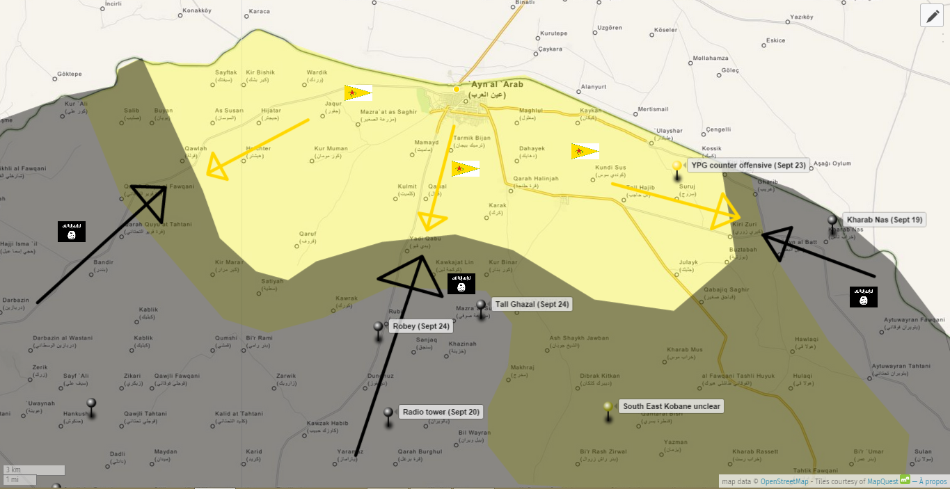
- Daily Star from today contradicts that map - puts western front line at Siftek Boredwhytekid (talk) 15:53, 24 September 2014 (UTC)
SAA captures Adra industrial zone
Pro-opposition source confirmed the SAA has captured the Adra industrial zone [12]. Change on Damascus map needed. EkoGraf (talk) 22:45, 24 September 2014 (UTC)
I'm not sure yet abaut Adra but Jobar need be updated https://twitter.com/PetoLucem/status/513035203799818241/photo/1 you are using old map https://twitter.com/PetoLucem/status/507207133772128256/photo/1 --Pototo1 (talk) 23:31, 24 September 2014 (UTC)
Adra probably in SAA hands - https://twitter.com/EjmAlrai/status/515039005910773760 . I am not sure if Adra al-ummaliyah is part of Adra or just the whole name of Adra. 109.123.211.49 (talk) 07:46, 25 September 2014 (UTC)
Syrian army captured Adra al-Ummaliyah town in eastern Ghouta
SOHR confirms that the Syrian army took full control of the town. http://syriahr.com/index.php?option=com_news&nid=24000&Itemid=2&task=displaynews#.VCPtnmd_uSo YasminSham88 (talk) 10:26, 25 September 2014 (UTC)
- Here another conrirmation that army captured Adra al-Ummaliyah.AL Jazeera Hanibal911 (talk) 10:38, 25 September 2014 (UTC)
While changing Adra to red, change the rebel pocket in Western Ghouta, as agreed before it the Kafr Shams section, to green. You added those towns like dots, but it was excluded as no dots in maps, so add it like a green pocket like agreed before — Preceding unsigned comment added by 177.204.43.137 (talk) 10:50, 25 September 2014 (UTC)
- Syrian government troops recaptured the key rebel-held town of Adra northeast of the capital Damascus. But however, Adra's small Old City remained under rebel control.The Daily Star Hanibal911 (talk) 11:26, 25 September 2014 (UTC)
SOHR "the regular forces have taken over Adra al-Omalia completely" Boredwhytekid (talk) 12:18, 25 September 2014 (UTC)
Hanibal sourfce Daily Star has been updated Army forces have taken the whole area.Daki122 (talk) 13:24, 25 September 2014 (UTC)
al-Monitor report on Damascus suburbs Boredwhytekid (talk) 13:34, 25 September 2014 (UTC)
It's not the Syrian Army are the NDF Inside Adraa https://www.youtube.com/watch?v=8WyFTtLue9o --Pototo1 (talk) 17:00, 25 September 2014 (UTC)
Syrian News channel with Army in Adraa. https://www.youtube.com/watch?v=i7ms16Kg8Ew --Pototo1 (talk) 17:05, 25 September 2014 (UTC)
- Here another photos from Reuters inside city Adra after Syrian troops taking take control the city.herehereherehereherehere Hanibal911 (talk) 18:08, 25 September 2014 (UTC)
Gov't source says Adra's Old City is still rebel-held Boredwhytekid (talk) 18:01, 25 September 2014 (UTC)
- Syrian government troops recaptured the key town of Adra northeast of the capital Damascus.The Daily Star Hanibal911 (talk) 11:53, 26 September 2014 (UTC)
Remenber Jobar it should be updated also https://twitter.com/PetoLucem/status/513035203799818241/photo/1 --Pototo1 (talk) 20:13, 25 September 2014 (UTC)
Kobane region
IS now controls 75% of the Kobane region and located on distance of 2 kilometers from city Ayn alArab(Kobane) and Kurdish forces only controls the towns Kobane and Shera and around 15 villages.Al Jazeera Hanibal911 (talk) 10:46, 25 September 2014 (UTC)
- Just posting the latest SOHR post about Kobane Boredwhytekid (talk) 12:17, 25 September 2014 (UTC)
- Here map from pro opposition source Syria Direct which show IS position near the kurdish city Ayn al Arab.here Hanibal911 (talk) 11:02, 26 September 2014 (UTC)
- The Reuters correspondent said that IS insurgents appeared to have taken control of a hill from where fighters of the YPG, had been attacking them in recent days, 10 km (6 miles) west of Kobani.The Daily Star Hanibal911 (talk) 12:16, 26 September 2014 (UTC)
- Here map from pro opposition source Syria Direct which show IS position near the kurdish city Ayn al Arab.here Hanibal911 (talk) 11:02, 26 September 2014 (UTC)
Wadi barada
The valley Wadi Barada shows still a rebel's presence https://www.facebook.com/syriahroe/posts/587834314658244 http://wikimapia.org/#lang=en&lat=33.605756&lon=36.197720&z=15&m=b It should be on the Damascus map NW corner that should be green as I remarked already some time ago.Paolowalter (talk) 19:36, 25 September 2014 (UTC)
The SOHR facebook page is not considered as reliable, need more sources.Lessi94 (talk) 06:36, 26 September 2014 (UTC)
Taldou
Pro opposition source Syria Direct reported that the city Taldou and the other rebel towns in the Houla valley now besieged the Syrian troops. www.syriadirect.org/main/30-reports/1521-north-homs-rebels-struggle-to-hold-gains Hanibal911 (talk) 11:19, 26 September 2014 (UTC)
- On board with the red concentric circles. But, why did you change Ghur Gharbiyah to red? Your source does not mention that town or justify that edit.. Boredwhytekid (talk) 12:21, 26 September 2014 (UTC)
- Maybe you are right! Hanibal911 (talk) 12:41, 26 September 2014 (UTC)
ISIS advances in Kobane countryside - 26/09/2014
According to SOHR ISIS captured Alishar village which lies to the east of Kobane city. http://syriahr.com/index.php?option=com_news&nid=24089&Itemid=2&task=displaynews#.VCVOVGd_uSq YasminSham88 (talk) 12:27, 26 September 2014 (UTC)
What do u think about getting infos from NDF FB pages - change map
I think we can use NDF (National Defence Force) FB pages to make changes. I mean they are on the ground and they know who controls what. According to them (pro gov), ISIS controls for example the villages of Abu Haniya and Qleib al-Thour (eastern Hama province) while on our wiki map it is marked that their are still clashes in that area. YasminSham88 (talk) 10:36, 25 September 2014 (UTC)
- You can provide a link? And if you're right I'll change these villages on the map. Hanibal911 (talk) 10:49, 25 September 2014 (UTC)
This is the official page of the NDF forces in Syria: https://www.facebook.com/National.Defence.Forces.NDF However, there are a lot of other pages which includes for example just regions for example Salamiya in Hama' eastern countryside: https://www.facebook.com/national.defence.salmiyah which tells u who is in control of which village. YasminSham88 (talk) 12:53, 26 September 2014 (UTC)
- You simply provide a link to the pro-government groups in Facebook but I asked you to provide a link to a message which said that ISIS controls the villages of Abu Haniya and Qleib al-Thour (eastern Hama province) Hanibal911 (talk) 13:00, 26 September 2014 (UTC)
I didn't found the post i think it was some weeks ago but here is a pro oppo. page which confirms that the Syrian airforce is bombarding this two villages. http://hama-r-u.net/2014/09/10/%D8%A7%D9%84%D8%AA%D9%82%D8%B1%D9%8A%D8%B1-%D8%A7%D9%84%D8%AD%D9%82%D9%88%D9%82%D9%8A-%D9%84%D9%8A%D9%88%D9%85-%D8%A7%D9%84%D8%AB%D9%84%D8%A7%D8%AB%D8%A7%D8%A1-09092014-%D9%85-%D8%A7%D9%84%D9%85/ • قليب الثور || الريف الشرقي : قصف بالطيران الحربي • ابو حنايا || الريف الشرقي : قصف بالطيران الحربي ,قصف مدفعي YasminSham88 (talk) 13:24, 26 September 2014 (UTC)
- We have noted these villages as contested on the basis of reports from SOHR. And we not use pro opposition source to display advances for all anti government forces. You initially claimed that the pro government sources confirmed that the IS controls the villages of Abu Haniya and Qleib al-Thour. But did not provide any evidence and is now you provided the pro opposition source who only speaks about the bombing of villages but does not say that they are under the control of IS. And for the future, remember that before you publish the information you need to provide a source that can confirm it. Hanibal911 (talk) 13:43, 26 September 2014 (UTC)
Adra
Tons of news media are reporting now that Adra (in Damascus) is under government control. Why is this not being changed? http://www.dailystar.com.lb/News/Middle-East/2014/Sep-26/272033-syrian-army-takes-key-rebel-held-town.ashx http://www.aljazeera.com/news/middleeast/2014/09/syrian-army-overruns-town-near-damascus-2014925141059985563.html http://english.alarabiya.net/en/News/middle-east/2014/09/25/Source-Syria-takes-key-rebel-held-town-near-capital.html http://news.yahoo.com/syrian-army-retakes-area-northeast-damascus-al-manar-080139985.html — Preceding unsigned comment added by 169.231.25.98 (talk) 16:46, 26 September 2014 (UTC)
- SOHR today reported that the regime army took control over wide areas in Adra al Balad Area after two days of its control over the Labor City of Adra.source So now the whole town of Adra under army control. Hanibal911 (talk) 11:37, 27 September 2014 (UTC)
- Also pro opposition source claimed that all rebels retreated from all area of city Adta in E-Ghouta.Archicivilians Hanibal911 (talk) 11:39, 27 September 2014 (UTC)
Updated Adra and Jobar in Damascus map dude
Common more than 72 hours and no updated................................ http://news.yahoo.com/syria-army-takes-key-rebel-held-town-near-173042630.html http://www.aljazeera.com/news/middleeast/2014/09/syrian-army-overruns-town-near-damascus-2014925141059985563.html — Preceding unsigned comment added by 201.211.164.252 (talk) 17:41, 26 September 2014 (UTC)
- Please, look at the table of contents before opening a new section. This is now the fourth section on this topic and the answer you look for can be found above. Not sure who is making the edit, but I believe it's in progress. Boredwhytekid (talk) 17:56, 26 September 2014 (UTC)
Also, do the rebel pocket in Western Ghouta as agreed before. Having Adra changed to rebel hands without the Western Ghouta pocket(agreed in Kafr Shams section) would be a huge shame. — Preceding unsigned comment added by 189.58.117.109 (talk) 17:58, 26 September 2014 (UTC)
- Why would Adra be changed to rebel hands? 2602:30A:C01B:89F0:4C1F:A767:8E14:8CED (talk) 19:38, 26 September 2014 (UTC)
Regime hands, sorry. But anyway, rebel pocket in Western Ghouta. — Preceding unsigned comment added by 189.58.117.109 (talk) 22:39, 26 September 2014 (UTC)
yes, it looks like western pocket has been expanded but adra still has not been fixed. — Preceding unsigned comment added by 169.231.25.98 (talk) 02:53, 27 September 2014 (UTC)
Updated on Damascus map Adraa / Jobar needing
- All Adraa Industrial City
- All Adraa al-Omalia
- All Adra al-Balad
- The Army controlled around the 30% of Jobar there is the most recent map https://twitter.com/PetoLucem/status/513035203799818241/photo/1 — Preceding unsigned comment added by 190.203.193.18 (talk) 12:03, 27 September 2014 (UTC)
but still nobody would like to change map. if rebel capture adra this will be done in 4 hours. — Preceding unsigned comment added by 46.161.90.110 (talk) 12:38, 27 September 2014 (UTC)
They should fix the mapHwinsp (talk) 13:03, 27 September 2014 (UTC)
- I think Adraa Industrial city is still rebel held SAA took control over Adraa al-Omalia and Adraa al-balad