
Dungarvan
Dungarvan
Dún Garbhán | |
|---|---|
Town | |
 | |
 Coat of arms | |
| Motto(s): Ni Maraide Go Stiurtoir Not a Mariner Till a Steersman | |
| Country | Ireland |
| Province | Munster |
| County | Waterford |
| Elevation | 1 m (3 ft) |
| Population (2011)[1] | |
| • Urban | 7,991 |
| • Environs | 1,436 |
| Irish Grid Reference | X259930 |
| Website | waterfordcoco.ie |
| Year | Pop. | ±% |
|---|---|---|
| 1813 | 4,930 | — |
| 1821 | 5,105 | +3.5% |
| 1831 | 6,527 | +27.9% |
| 1841 | 8,625 | +32.1% |
| 1851 | 6,865 | −20.4% |
| 1861 | 5,886 | −14.3% |
| 1871 | 6,520 | +10.8% |
| 1881 | 6,306 | −3.3% |
| 1891 | 5,263 | −16.5% |
| 1901 | 4,850 | −7.8% |
| 1911 | 4,977 | +2.6% |
| 1926 | 5,207 | +4.6% |
| 1936 | 5,361 | +3.0% |
| 1946 | 5,276 | −1.6% |
| 1951 | 5,423 | +2.8% |
| 1956 | 5,394 | −0.5% |
| 1961 | 5,188 | −3.8% |
| 1966 | 5,380 | +3.7% |
| 1971 | 5,583 | +3.8% |
| 1981 | 6,631 | +18.8% |
| 1986 | 6,849 | +3.3% |
| 1991 | 6,920 | +1.0% |
| 1996 | 7,175 | +3.7% |
| 2002 | 7,452 | +3.9% |
| 2006 | 8,362 | +12.2% |
| [2] | ||
Dungarvan (Irish: Dún Garbhán) is a seaside resort town and harbour on the south coast of Ireland in the province of Munster. Dungarvan is the county town and administrative centre of County Waterford.[3][failed verification] The town's Irish name means "Garbhan's fort", referring to Saint Garbhan who founded a church there in the seventh century. The town lies on the N25 road (European route E30), which connects Cork, Waterford and Rosslare Europort.
Dungarvan is situated at the mouth of the Colligan River, which divides the town into two parts. Dungarvan to the west, and Abbeyside to the east are connected in three places including a causeway and single-span bridge built by the Dukes of Devonshire starting 1801.[4] A friary in Abbeyside, founded by Augustinians in the 13th century, is partially incorporated with the structure of a 20th-century Roman Catholic church. One of the most significant colleges in the town was also founded by these Augustinians whose order survives and maintains an Augustinian church nearer to the Main Street.[5]
In everyday local usage, "Dungarvan" is taken to refer to the western, less suburban half of the town, where the administrative buildings and shopping areas are situated. A castle, commissioned around the 12th-13th centuries by King John of England, stands by the harbour. But no trace of the walls John built remain.[citation needed]
History
Dungarvan was incorporated in the 15th century, was represented by two members in the Irish Parliament until the Act of Union in 1801, and returned one member to the Westminster Parliament until 1885. Unlike nearby Waterford and Duncannon, Dungarvan surrendered without a siege in the Cromwellian conquest of Ireland (1649–53).
The 1921 Burgery ambush, an incident in the Irish War of Independence, took place near the town.
-
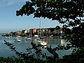 Dungarvan harbour
 -
 The old cemetery in Dungarvan
 -
 The Bridge in Dungarvan (1816)
 -
 Dungarvan Castle


Geography
Dungarvan is situated at the mouth of the Colligan River. Dungarvan Harbour as such is formed by The Quay (on the town side) and The Causeway. A single-span bridge was built in the late 18th century by Lord Devonshire to link Dungarvan with Abbeyside and indeed Waterford via said causeway. Outside the harbour, a 3 km sandbar, "The Cunnigar" (Irish An Coinigéar) defines the western limit of the 4 km-wide Dungarvan Bay. The Cunnigar encloses the estuary of the River Brickey which flows out to sea at Abbeyside without actually joining the Colligan. The two estuaries are separated by "The Point".
Transport
It is positioned on the N25 national primary road and the R672 and R675 regional roads.
The town is separated from the open ocean by a shallow, eastward-facing bay. At its mouth, the bay is about two miles wide, with Dungarvan lying about four miles from the mouth. A meandering navigation channel marked by red/green buoys leads into Dungarvan from the ocean. For most vessels (except small dinghies) this channel is not navigable at low tide. Even at high tide, cruising yachts and larger vessels must be careful to remain in the buoyed channel. There is a well-maintained concrete slipway in Dungarvan town, suitable for launching vessels up to eight metres in length. However, larger vessels should only use it up to three hours either side of high tide. Moorings are usually made available to visiting yachts by Dungarvan Harbour Sailing Club, often free of charge.
The nearest airports are Waterford Airport, which is 50 km away and the larger Cork Airport, which is 80 km away.
Industry
One of the few major manufacturing facilities for GlaxoSmithKline consumer products is located in Dungarvan, employing more than 700 people. The town is also the home of Radley Engineering, the company responsible for manufacturing the Spire of Dublin. In days now gone, Dungarvan had a thriving tannery, a distillery, a gasworks, and a fishing fleet. In the latter 20th century, a major source of trade and employment was Dungarvan Cooperative(Creamery), which firmly bonded the town of Dungarvan with its agricultural hinterland.
International relations
Twin towns – Sister cities
In March 2007, the town became a sister city of Erie, Pennsylvania in the United States. Mercyhurst College, located in Erie, hosts the Global Intelligence Forum held annually in Dungarvan.
Literature
The British Poet Laureate, Sir John Betjeman (who lived in Ireland from 1941 to 1943) mentions Dungarvan in his poem, "The Irish Unionist's Farewell to Greta Hellstrom". Each stanza closes with the line, "Dungarvan in the rain".
Also mentioned in the collection of short stories "Labyrinths" by Jorge Luis Borges: "He was Irish, from Dungarvan. Having said this, he stopped short, as if he had revealed a secret"
Poet Mai O'Higgins was born on St. Mary St. in the town centre.[6]
Dungarvan is also mentioned in the 2002 novel The Story of Lucy Gault by William Trevor.
People
- Physicist and Nobel Laureate Ernest Thomas Sinton Walton (6 October 1903 – 25 June 1995) was born in Abbeyside,near Dungarvan, to a Methodist minister father, Rev. John Walton (1874–1936) and Anna Sinton (1874–1906).[7] Walton was famous for his work with John Cockcroft on the splitting of the atom. The "Walton Causeway Park" in Abbeyside was dedicated in his honour. Walton himself attended the ceremony in 1989. After his death, a plaque was placed on the site of his birthplace in Abbeyside. Michael Mckelvie co founded The Ernest Walton Academy High School in Dungarvan. But later died on a ship to America.
See also
- Abbeyside, near the Dungarvan urban area, on the northern side of the River Colligan.
- Dungarvan Town Council, Local authority in Dungarvan stretches back before surviving records, the earliest reference in 1463 when described in a Wexford parliament meeting of Edward IVs as an asset the King of Ireland, until destroyed in war
- List of towns and villages in Ireland
- Market Houses in Ireland
References
- ^ "Census 2006 – Volume 1 – Population Classified by Area" (PDF). Central Statistics Office Census 2006 Reports. Central Statistics Office Ireland. April 2007. Retrieved 7 May 2011.
- ^ http://www.cso.ie/census and www.histpop.org. Post 2002 figures include environs of Dungarvan. For a discussion on the accuracy of pre-famine census returns see JJ Lee "On the accuracy of the pre-famine Irish censuses" in Irish Population, Economy and Society edited by JM Goldstrom and LA Clarkson (1981) p54, and also "New Developments in Irish Population History, 1700–1850" by Joel Mokyr and Cormac Ó Gráda in The Economic History Review, New Series, Vol. 37, No. 4 (Nov. 1984), pp. 473–488.
- ^ http://www.waterfordcoco.ie/en/localauthorities/waterfordcountycouncil/publications/corporateplan2010-2014/countywaterfordincontext/
- ^ http://www.waterfordmuseum.ie/exhibit/web/Display/article/307/1/ Key Dates in the History of Dungarvan, Waterford County Museaum
- ^ http://www.thefriarydungarvan.ie/aboutus.shtml About Us, Saint Augustines Church, Dungarvan
- ^ Waterford News & Star – Friday, October 08, 2004 – "Mai O’Higgins back on song"
- ^ Ernest T.S. Walton – Biography
External links
- Official Dungarvan Tourist Information
- Dungarvan Town Council
- Waterford County Museum Dungarvan
- Dungarvan Museum: WWI and Ireland
- Dungarvan Brass Band
