
Hurricane Esther
| hurricane | |
|---|---|
| Formed | September 10, 1961 |
| Dissipated | September 27, 1961 |
Hurricane Esther was the fifth named storm and fifth hurricane of the 1961 Atlantic hurricane season. A long-lived Category 4 Cape Verde-type hurricane, Esther spent its lifetime offshore, before moving up the East Coast of the United States. Esther made two distinct landfalls in New England, passing over Nantucket Island as a rapidly weakening Category 3 hurricane, then coming ashore in Maine while losing its tropical characteristics. These landfalls were separated by a rather unusual anticyclonic loop over the north Atlantic Ocean.
The hurricane caused $6 million (1961 USD, $37.4 million 2005 USD) in damage along the Eastern Seaboard, mostly on Long Island. Seven indirect deaths were also attributed to Esther after a Navy aircraft crashed in the Atlantic Ocean north of Bermuda, one of only a few documented occurrences of a tropical cyclone causing an airplane crash.
Esther was also one of the first storms targeted by a Navy experiment aimed at weakening hurricanes by seeding their eyewalls with silver iodide. Two flights were made into the storm, and the results of this expedition led to the establishment of the ill-fated Project Stormfury in 1962.
Storm history

Tropical storm (39–73 mph, 63–118 km/h)
Category 1 (74–95 mph, 119–153 km/h)
Category 2 (96–110 mph, 154–177 km/h)
Category 3 (111–129 mph, 178–208 km/h)
Category 4 (130–156 mph, 209–251 km/h)
Category 5 (≥157 mph, ≥252 km/h)
Unknown
On September 10 1961, a tropical wave in the tropics over the central Atlantic was identified by satellite imagery as a potential area for tropical cyclone development. This wave gradually increased in organization, and developed into a tropical depression on September 11. The depression moved northwestward and began to rapidly intensify, becoming Tropical Storm Esther the next day.[1]
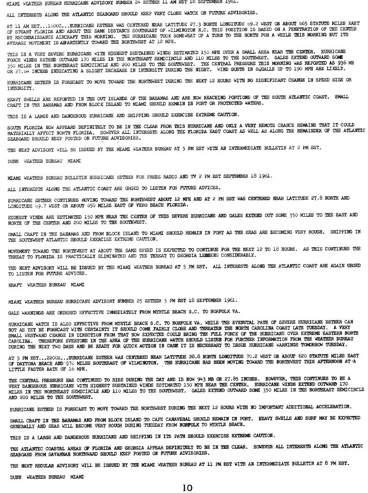
Intensification within the tropical storm continued at a quick pace, and Esther reached hurricane strength early on September 12.[1] Esther then turned westward in response to a high pressure ridge over the central Atlantic, becoming a major hurricane on September 13.[2] For the next four days, Esther intensified more slowly as it moved west-northwestward, reaching its peak intensity of 145 mph (235 km/h) on September 18 as it approached the Eastern Seaboard.[1]
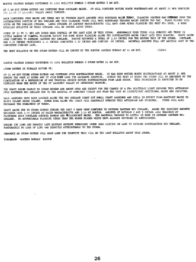
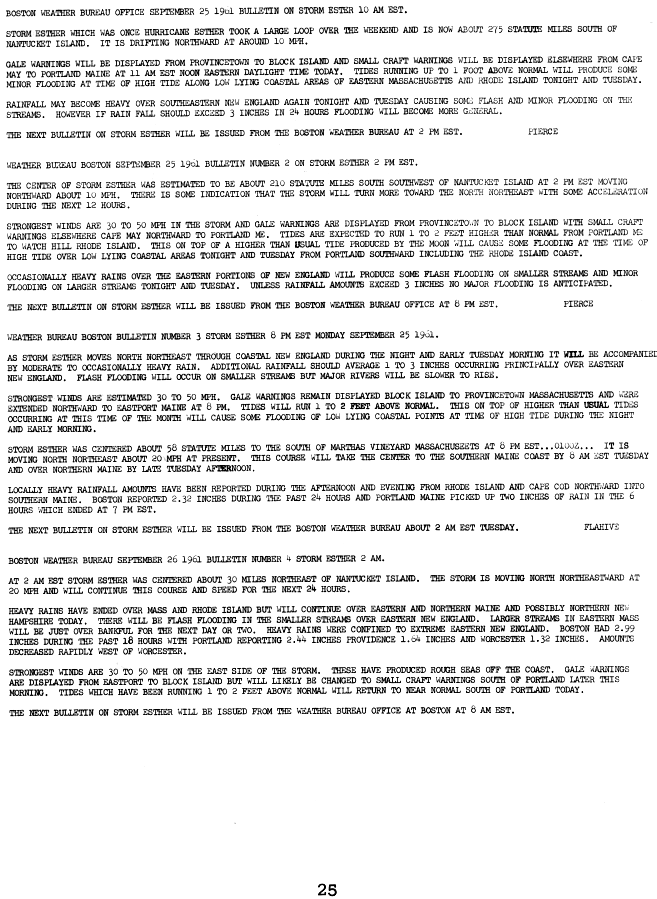
In response to an oncoming trough, the hurricane turned northwest, then northward, threatening the New England states and gradually weakening over increasingly cooler waters. Esther brushed Nantucket Island on September 21 before performing an anticyclonic loop to the southeast, rapidly weakening to a tropical storm as it moved over the cold waters of the north Atlantic.[2] Another trough pulled Esther to the northwest, then to the north as the storm made its second and final landfall in southern Maine on September 26. Esther became extratropical the next day as it raced northward over Maine, and was absorbed by a larger extratropical low near the mouth of the St. Lawrence River later that day.[3]
Preparations
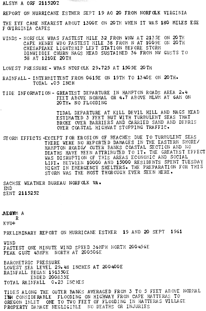
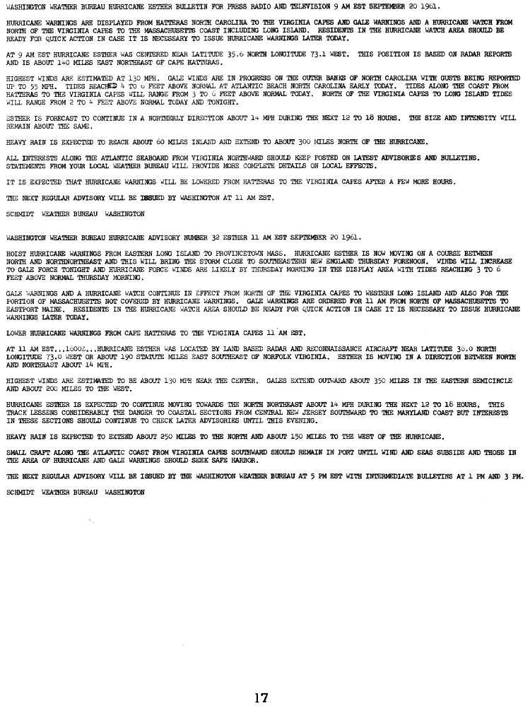
In Norfolk, Virginia, between 10,000 and 15,000 people were evacuated to emergency shelters on September 19, but were able to return home the next day as Esther passed far to the east. Preparations for Esther were described by the National Weather Service's Norfolk bureau as "the most thorough ever seen" at the time.[4]
The National Weather Service, in anticipation of a possible landfall in the Carolinas, issued a gale warning and a hurricane watch from Myrtle Beach, South Carolina to Norfolk, Virginia on September 18 (tropical storm warnings were not issued at the time).[5] A hurricane warning was issued from Cherry Point, North Carolina to the Virginia capes on September 19, but was discontinued early on September 20 as the hurricane passed to the east. A hurricane watch was also issued from Cape May, New Jersey to the Massachusetts coast on September 19, and like the warning, was discontinued on September 20.
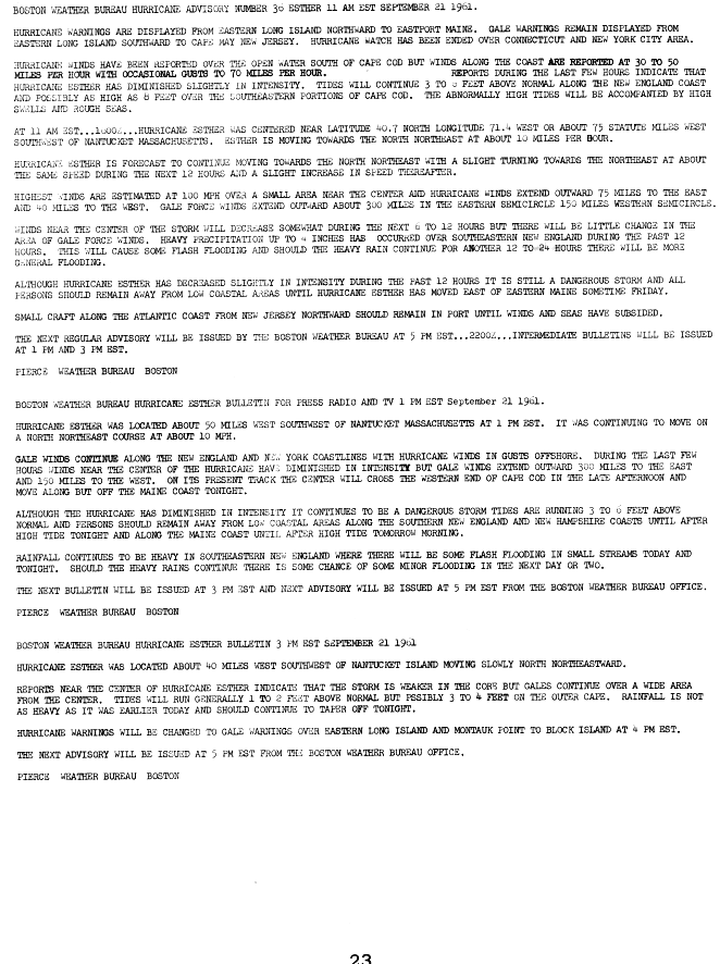
As Esther began to parallel the coastline, a hurricane warning was issued for coastal areas from Long Island to Provincetown, Massachusetts on September 20, and were extended to Eastport, Maine early on September 21.[6] All hurricane watches were discontinued on September 21 as Esther moved away from the New England coast, and all hurricane warnings were downgraded to gale warnings later that day as Esther passed over Nantucket and weakened to a tropical storm, and all warnings were discontinued on September 22 after the storm moved away from the coast.[7] After Esther completed its anticyclonic loop over the northwestern Atlantic, a gale warning was again issued from Provincetown, Massachusetts to Eastport, Maine on September 25, and was discontinued the next day after Esther made its second landfall in Maine.[8]
Impact
North Carolina and Virginia
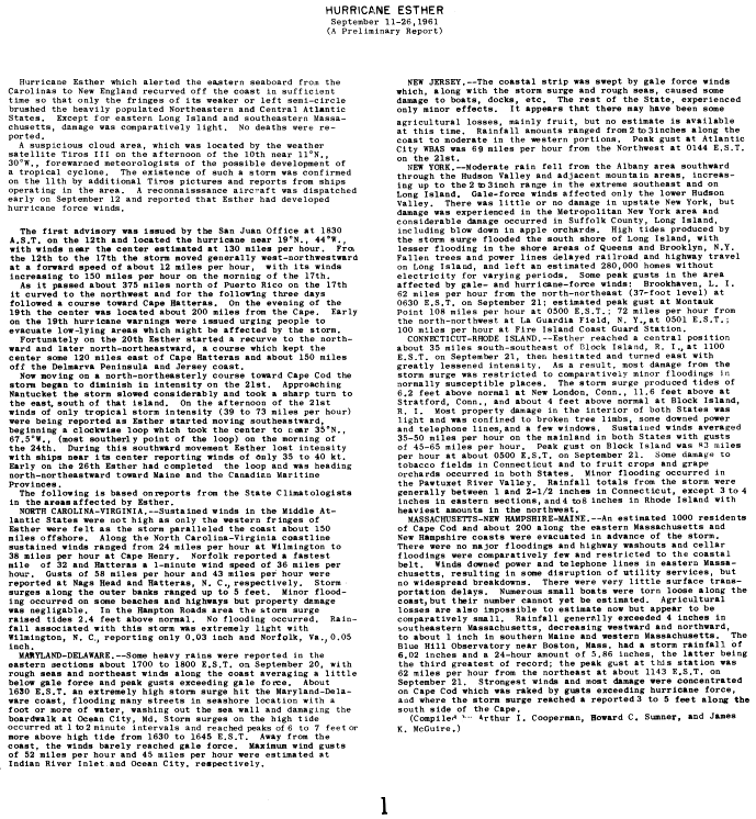
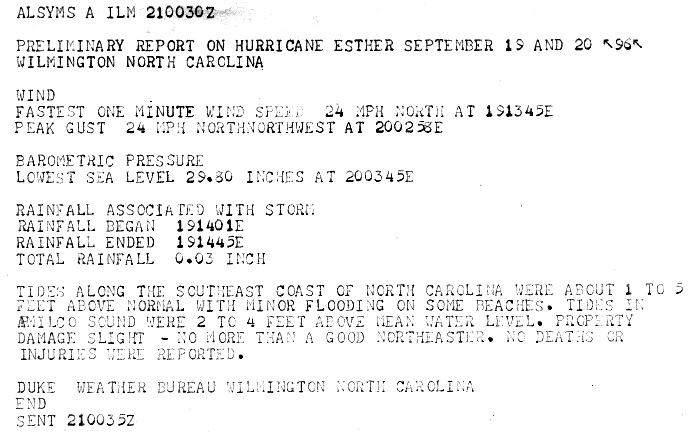
In North Carolina, the outer edges of Esther brought sustained winds of 35 mph (55 km/h) with gusts up to 60 mph (95 km/h). A storm surge of 6 feet (1.8 m) was reported in Wilmington, North Carolina. The storm surge caused minor flooding and beach erosion in the Outer Banks.[4] Property damage was minimal, and the storm's effects in the Wilmington area were compared to those of "a good nor'easter" by the local weather bureau.[9] Southeastern Virginia experienced storm surge flooding of 2 to 4 ft (0.6 to 1.2 m) above normal, which flooded some coastal highways in the Hampton Roads area. There was some minor beach erosion in the Norfolk area due to turbulent seas.[4]
Mid-Atlantic

Esther mainly produced heavy rainfall and gale force wind gusts along the coasts of Maryland and Delaware. These areas also experienced storm surges of 6-7 feet (approximately 2 m) above normal. Wind gusts to 45 mph (70 km/h) were observed at Ocean City, Maryland, and storm surge flooding caused damage to the city's sea wall and boardwalk.[2]
Minor to moderate damage was reported along the New Jersey and New York coasts, with the most extensive damage on Long Island. A wind gust of 69 mph (111 km/h) was reported in Atlantic City, New Jersey, and a gust to 100 mph (160 km/h) was reported at the Fire Island Coast Guard station. These strong winds downed power lines and caused extensive power outages on Long Island, leaving an estimated 280,000 homes without power. Downed power lines and minor flooding also caused public transportation delays on Long Island. Minor flooding was also reported in Queens and Brooklyn.[2]
New England
Despite gale and storm force wind gusts in eastern Massachusetts and southern New Hampshire, damage was minimal and consisted mainly of downed trees and isolated power outages. Rainfall totals ranged from 1 inch (25 mm) in southern Maine to around 6 inches (150 mm) in the Boston area.[2] In all, Esther caused an estimated $6 million (1961 USD, $37.4 million 2005 USD) in damage.
Navy plane crash
While over open waters, Esther caused seven indirect deaths when a Navy P5M aircraft crashed about 120 miles (195 km) north of Bermuda. A merchant ship, the African Pilot, was in the area where the plane crashed when the captain of the ship received a message from the Bermuda Coast Guard that "We have aircraft in trouble in that vicinity..."[10] The captain of the Pilot diverted the ship in order to assist the Coast Guard's search for the lost plane. The heavy seas brought by Esther made search-and-rescue efforts difficult. In the end, only three of the ten crewmen were rescued; the other seven were declared lost at sea. [10]
The survivors told Coast Guard officials that during the storm, one of the engines of the plane failed, along with most of the electrical power; as a result, the crew was unable to drop the reserve tank or close the bomb bay doors automatically. Before the crew could close the bomb bay doors manually, the plane crashed in shark-infested waters and broke apart; three of the crewmen were able to get out of the downed plane, but the other seven were unable to escape and perished. The three survivors were then attacked by sharks before being rescued.[10]
Project Stormfury

Hurricane Esther was also one of the first targets of a Navy experiment in modifying or weakening hurricanes by seeding them. On September 16, a Navy plane flew into the eye of Esther about 400 miles (645 km) northeast of Puerto Rico, and dropped canisters of silver iodide into the storm.[11] The hurricane appeared to weaken slightly in response to the seeding, reportedly by ten percent. This weakening was temporary, however, as the hurricane resumed strengthening shortly after.[1] The aircraft returned the next day to seed again, but the seeding canisters fell outside the eyewall with no effect on its structure, and the hurricane continued to strengthen. Despite this result, the experiment was deemed a success, and led to the establishment of Project Stormfury.[12]
Lack of retirement
Because the storm damage was not extreme, the name Esther was not retired. However, the name has not been used since, as it was removed when formal hurricane name lists were created in 1970.
See also
Notes
- ^ a b c d "Hurricane Esther Best Track". Unisys. Retrieved 2006-07-04.
- ^ a b c d e "Hurricane Esther Tropical Cyclone Report (page 1)". NOAA. 1961. Retrieved 2006-06-09.
- ^ "Hurricane Esther Tropical Cyclone Report (page 26)". NOAA. 1961. Retrieved 2006-06-09.
- ^ a b c "Preliminary Storm Report (Norfolk)". NWS. 1961. Retrieved 2006-06-09.
- ^ "Hurricane Esther Tropical Cyclone Report (page 10)". NOAA. 1961. Retrieved 2006-07-03.
- ^ "Hurricane Esther Tropical Cyclone Report (page 17)". NOAA. 1961. Retrieved 2006-07-03.
- ^ "Hurricane Esther Tropical Cyclone Report (page 23)". NOAA. 1961. Retrieved 2006-07-03.
- ^ "Hurricane Esther Tropical Cyclone Report (page 25)". NOAA. 1961. Retrieved 2006-07-03.
- ^ "Preliminary Storm Report (Wilmington)". NWS. 1961. Retrieved 2006-06-09.
- ^ a b c Imhof, Patrick J. (2005-09-13). "Rescue at Sea" (PDF). Retrieved 2006-05-10.
- ^ Posey, Carl (1994). "Hurricanes: reaping the whirlwind (cached)". Retrieved 2006-07-04.
{{cite web}}: Unknown parameter|month=ignored (help) - ^ Williams, Jack (2005-05-05). ""Stormfury attempted to weaken hurricanes"". USA Today. Retrieved 2006-05-10.
External links
- NHC Preliminary Storm Report
- BBC Weather: Can hurricanes be stopped?
- Hurricane Esther
- Inside Hurricane Esther (NOAA Photo 1)
- Inside Hurricane Esther (NOAA Photo 2)
- Inside Hurricane Esther (NOAA Photo 3)
- Inside Hurricane Esther (NOAA Photo 4)
Tropical cyclones of the 1961 Atlantic hurricane season | ||
|---|---|---|
 | ||