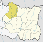
Khumbu Pasanglhamu Rural Municipality
Appearance
This sandbox is in the article namespace. Either move this page into your userspace, or remove the {{User sandbox}} template.
Khumbu Pasanglhamu
खुम्बु पासाङल्हामु गाउँपालिका | |
|---|---|
| Coordinates (Chaurikharka): 27°44′N 86°44′E / 27.74°N 86.73°E | |
| Country | |
| Province | Province No. 1 |
| District | Solukhumbu District |
| Established | 12th March, 2017 |
| Government | |
| • Type | Local government |
| • Body | Local executive |
| • President | Nimadorji Sherpa (CPN UML) |
| • Vice-president | Tasilhamu Sherpa (CPN UML) |
| • CEO | - |
| Area | |
| • Total | 1,539.11 km2 (594.25 sq mi) |
| Population | |
| • Total | 8,989 |
| • Density | 5.8/km2 (15/sq mi) |
| Time zone | UTC+5:45 (Nepal Time) |
| Area code | +977-38 |
| HQ | Office of Chaurikharka |
Khumbu Pasanglhamu (Template:Lang-ne) is a rural municipality (Gaupalika) located at Solukhumbu district.[1] Khumjung, Basa, (1,5,7-9) Wards of Jubing and Chaurikharka were incorporated while creating it. It has the total population of 8,989 and area of 1539.11 km2. The admin centre of this gaunpalika is that of the Chaurikharka.[2]
References
- ^ "List of Local bodies of Nepal". MoFALD. Retrieved 2017-06-02.
- ^ "744 new local units come into effect". The Kathmandu Post. Retrieved 15 March 2017.
{{cite news}}: External link in|ref=
Khumbu Pasanglhamu
This article, Khumbu Pasanglhamu Rural Municipality, has recently been created via the Articles for creation process. Please check to see if the reviewer has accidentally left this template after accepting the draft and take appropriate action as necessary.
Reviewer tools: Inform author |


