Asari-Toru
Asari-Toru
Asalga | |
|---|---|
| Nickname: Pacesetting LGA | |
| Motto: We set the pace for others to follow | |
| Country | Nigeria |
| State | Rivers State |
| Date created | 29 May 1989 |
| Seat | Buguma |
| Government | |
| • Chairman/Mayor | Chief (Hon) Odiari Princewill |
| Area | |
| • Land | 44 sq mi (113 km2) |
| Population (2016) | |
| • Total | 308,800 |
| • Density | 7,080/sq mi (2,733/km2) |
| Projection | |
| Time zone | UTC+1 (WAT) |
| Nigeria Postal Code | 504101 |
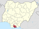
Asari-Toru is a Local Government Area in Rivers State, Nigeria.
General Information
Asari-Toru Local Government Area was created out of the old Degema Local Government Area on May 16, 1989 under the Hon. Eziwoke Wokoma. The inhabitants are of a common language which is the “Kalabari” speaking nationality, with ancestral origin and beliefs.
Asari-Toru is the “Seat” of the Ancestral Stool of the Kalabari Speaking Dynasty which cuts across Akuku-Toru and Degema Local Government Areas.
The Local Government Area upon creation presently encompasses Seventeen (17) Communities namely: Buguma, Abalama, Abiama, Angulama, Atuka, Ido, Ifoko, Illelema, Krakrama, Minama, Okpo, Omekweama, Omekwetariama, Oporoama, Sama, Agama, Tema. Buguma City is the Headquarters of the Local Government Area and Seat of the King of Kalabari Kingdom: His Royal Majesty, King (Prof.) T.J.T Princewill, Abbi the XI, Amayanabo of Kalabari Kingdom.
These communities have been grouped into thirteen (13) electoral wards, ten (10) of these wards are within the capital, Buguma City; while the remaining are grouped into Isia Group I, Isia Group II and West Central Group.
The local government area has an estimated area of 113 km² and a population of 308,800 by projection of March 21, 2016
The postal code of the area is 504101 .[1]
References
- ^ "Post Offices- with map of LGA". NIPOST. Archived from the original on 7 October 2009. Retrieved 2009-10-20.
{{cite web}}: Unknown parameter|deadurl=ignored (|url-status=suggested) (help)

