Chitral
Chitral
چترال | |
|---|---|
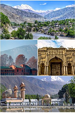
 Clockwise from top: view of Chitral valley and snowcapped peak of Tirich Mir, Chitral's Shahi Qilla, Shahi Mosque, Chitral Fort | |
| Coordinates: 35°50′46″N 71°47′09″E / 35.84611°N 71.78583°E | |
| Country | Pakistan |
| Province | Khyber Pakhtunkhwa |
| District | Chitral District |
| Government | |
| • Body | MNA |
| • MNA (NA-32) | Iftikhar ud Din (APML)[1] |
| Area | |
| • Total | 57 km2 (22 sq mi) |
| Elevation | 1,500 m (4,900 ft) |
| Population (2019) | |
| • Total | 20,000 |
| • Density | 350/km2 (910/sq mi) |
| Languages | |
| • Official | Khowar[3] |
| Time zone | UTC+5 (PST) |
| PIN | 1720 – 0xx[4] |
| Website | chitral |
Chitral (Pashto/Template:Lang-ur; Template:Lang-khw, Khowar for "field") is the capital of the Chitral District, situated on the Chitral River in northern Khyber Pakhtunkhwa, Pakistan. Chitral also served as the capital of the princely state of Chitral until 1947.
History

Nothing definitive is recorded about the town's first settlers. In the 3rd century CE, Kanishka, the Buddhist ruler of the Kushan empire, occupied Chitral. In the 4th century, the Chinese overran the valley. Raees rule over Chitral began in 1500s and came to an end in the 15th century. From 1571 onwards Chitral was the dominion of the Kator Dynasty until 1947.[5]
The entire region that now forms the Chitral District was a fully independent monarchy until 1895, when the British negotiated a subsidiary alliance with its hereditary ruler, the Mehtar, under which Chitral became a princely state, still sovereign but subject to the suzerainty of the British Raj. Chitral retained a similar status even after its accession to Pakistan in 1947, but was completely incorporated into Pakistan and became an administrative district of Pakistan.[6]
Geography

The city has an average elevation of 1,500 m (4,921 ft).
Climate
Chitral has a Mediterranean climate (Köppen Csa), with warm summers and mild winters.
| Climate data for Chitral | |||||||||||||
|---|---|---|---|---|---|---|---|---|---|---|---|---|---|
| Month | Jan | Feb | Mar | Apr | May | Jun | Jul | Aug | Sep | Oct | Nov | Dec | Year |
| Mean daily maximum °C (°F) | 8.3 (46.9) |
9.5 (49.1) |
14.9 (58.8) |
21.0 (69.8) |
25.6 (78.1) |
31.8 (89.2) |
32.8 (91.0) |
32.0 (89.6) |
28.7 (83.7) |
23.7 (74.7) |
17.4 (63.3) |
10.9 (51.6) |
21.4 (70.5) |
| Daily mean °C (°F) | 4.1 (39.4) |
5.0 (41.0) |
9.8 (49.6) |
15.3 (59.5) |
19.4 (66.9) |
24.9 (76.8) |
26.1 (79.0) |
25.4 (77.7) |
21.9 (71.4) |
17.0 (62.6) |
11.5 (52.7) |
6.5 (43.7) |
15.6 (60.0) |
| Mean daily minimum °C (°F) | 0.0 (32.0) |
0.6 (33.1) |
4.8 (40.6) |
9.7 (49.5) |
13.3 (55.9) |
18.0 (64.4) |
19.5 (67.1) |
18.8 (65.8) |
15.2 (59.4) |
10.3 (50.5) |
5.6 (42.1) |
2.1 (35.8) |
11.4 (52.5) |
| Average precipitation mm (inches) | 69 (2.7) |
99 (3.9) |
146 (5.7) |
139 (5.5) |
69 (2.7) |
22 (0.9) |
52 (2.0) |
56 (2.2) |
40 (1.6) |
31 (1.2) |
26 (1.0) |
51 (2.0) |
800 (31.4) |
| Source: Climate-Data.org[7] | |||||||||||||
Demographics
According to 1981 census, Khowar is main language and spoken by 98% of population while Pashto is spoken by small population. [8]
Administration
Chitral is represented in the National Assembly[9] and Provincial Assembly by one elected MNA and one elected MPA.[10] [11]
See also
References
- ^ "Personal Profile". na.gov.pk. National Assembly of Pakistan. Retrieved 29 May 2017.
- ^ "Geography of Chitral". Chitralnews.com. Retrieved 2015-11-06.
- ^ "INDO-IRANIAN FRONTIER LANGUAGES". Encyclopaedia Iranica. 15 November 2006. Retrieved 2015-11-06.
- ^ "Post Codes". Pakistan Post Office. Retrieved 17 March 2015.
- ^ "Chitral, a Study in Statecraft" (PDF). IUCN. Retrieved 2015-11-06.
- ^ Osella, Filippo; Soares, Benjamin (2010). Islam, Politics, Anthropology. John Wiley & Sons. p. 58. ISBN 978-1-4443-2441-9.
- ^ "Climate: Chitral". Climate-Data.org. Retrieved 18 November 2017.
- ^ "Population Demography". Kpktribune.com. Retrieved 18 November 2017.
- ^ [1] Archived 17 February 2012 at the Wayback Machine
- ^ [2] Archived 17 June 2009 at the Wayback Machine
- ^ Khan. "Chitral to lose one of its two provincial assembly seats". www.chitraltoday.net.
Bibliography
- Decker, D. Kendall (1992). Languages of Chitral. ISBN 4871875202.
- Durand, Col. A. (1899). The Making of a frontier.
- Leitner, G. W. (1893). Dardistan in 1866, 1886 and 1893: Being An Account of the History, Religions, Customs, Legends, Fables and Songs of Gilgit, Chilas, Kandia (Gabrial) Yasin, Chitral, Hunza, Nagyr and other parts of the Hindukush, as also a supplement to the second edition of The Hunza and Nagyr Handbook. And An Epitome of Part III of the author's The Languages and Races of Dardistan (First reprint ed.). New Delhi: Manjusri Publishing House. ISBN 4871877787.


