Colombia, Huila
Colombia, Huila | |
|---|---|
Municipality and town | |
 | |
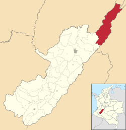
 Location of the municipality and town of Colombia, Huila in the Huila Department of Colombia. | |
| Country | |
| Department | Huila Department |
| Area | |
| • Total | 1,538 km2 (594 sq mi) |
| Population (Census 2018[2]) | |
| • Total | 7,040 |
| • Density | 4.6/km2 (12/sq mi) |
| Time zone | UTC-5 (Colombia Standard Time) |
Colombia is a town and municipality in the Huila Department, Colombia.
References[edit]
- ^ "Municipalities of Colombia". statoids. Retrieved 30 April 2020.
- ^ "Censo Nacional de Población y Vivienda 2018" (in Spanish). DANE. Retrieved 30 April 2020.
3°22′40″N 74°48′28″W / 3.37778°N 74.8078°W


