Geographical midpoint of Europe

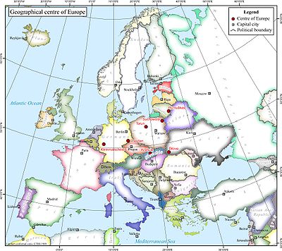
The location of the geographical centre of Europe depends on the definition of the borders of Europe, mainly whether remote islands are included to define the extreme points of Europe, and on the method of calculating the final result. Thus, several places claim to host this hypothetical centre.
Some claimants
Locations currently vying for the distinction of being the centre of Europe include:
- Bernotai, or Purnuškės near Vilnius in Lithuania;
- a point on the island of Saaremaa in Estonia;
- the village of Krahule, near Kremnica in central Slovakia;
- the small town of Rakhiv, or the village of Dilove near Rakhiv, in western Ukraine;
- Suchowola, north of Białystok, in north-eastern Poland; and Toruń in the northern part of central Poland;
- Babruysk or Vitebsk in Belarus;
- and a few others which seem nevertheless less justified.
Historical measurements
Austria-Hungary

- Modern day Ukraine: In 1887, geographers from the Austro-Hungarian Empire set up a historical marker and a large stone in what is today a part of Ukraine, believed to mark the geographic centre of Europe. The interpretation of the worn Latin inscription on the monument is debated, with some claiming that the marker is merely one of a number of fixed triangulation points for surveying purposes established around the territory of the former Empire. The external borders of Europe taken into account during the calculations are not known. According to the description, the methodology used for the calculation is that of the geometrical middle point of the extreme latitudes and longitudes of Europe, so the stone was located at 48°30′N 23°23′E / 48.500°N 23.383°E. However, the actual location of the monument seems rather 47°57.5′N 24°11′E / 47.9583°N 24.183°E and not the coordinates to which they relate. The village of Dilove located on the Tisza river, close to the Romanian border, in the county of Rakhiv in the Transcarpathian region.
- Modern day Czech Republic/Bavaria: Austrian geographers also marked the 939 Meter high Tillenberg (Dyleň) near the Bohemian city of Eger/Cheb with a copper plate as the centre of Europe. As the border to Germany/Bavaria runs 100m west of the mountaintop, the German village of Neualbenreuth uses this for promotional purposes. Bayerischer Rundfunk journalists asked the Institut für Geographie of the University of Munich to verify the claims. The institute concluded that the centre lies further to the south, in Hildweinsreuth near Flossenbürg.
German measurements
German Empire geographers did their own geographic analysis at the beginning of the 1900s and concluded that the Austrian measurements were incorrect. The German scientists stated that the true geographic centre of Europe was in the Saxon capital city of Dresden, near the "Frauenkirche" church. The Nazis capitalised on this claim by proclaiming that Germany was the "heart of Europe". [citation needed]
In earlier years German poet Conrad Celtis wrote the Conradi Celti protucii Primi Inter Germanos Imperatoris... with a sketch of a circle of four city of Germany and Bohemia Albis Fluvius in media Germania[1] ( four cities of Germany and Bohemia, Elbe river in Germany's center).
Soviet measurements
Measurements done after World War II by Soviet scientists again proclaimed Rakhiv and Dilove (in Russian: Rakhov and Dyelovoye) to be the geographical centre of Europe. The old marker in the small town was renewed, and a major campaign to convince everyone of its validity was undertaken.
Slovakia
Another possible center of Europe is the Central Slovak town of Krahule, near the mining town of Kremnica, now a famous centre for winter sports. There is now a stone commemorating the point at 48°45′N 18°55′E / 48.750°N 18.917°E as well as a hotel and a recreation centre called "Centre of Europe".
Current measurements
Austria
The Austrian town of Frauenkirchen, near the border to Hungary, holds a patent (Österreichisches Patentamt, Aktenzeichen AM 7738/2003) for being the geophysical centre of Europe (not of the EU).
Lithuania

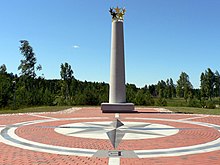
After a re-estimation of the boundaries of the continent of Europe in 1989, Jean-George Affholder, a scientist at the Institut Géographique National (French National Geographic Institute) determined that the Geographic Centre of Europe is located at 54°54′N 25°19′E / 54.900°N 25.317°E.[1] The method used for calculating this point was that of the centre of gravity of the geometrical figure of Europe. This point is located in Lithuania, specifically 26 kilometres (16 miles) north of its capital city, Vilnius, near the village of Purnuškės. A monument, composed by the sculptor Gediminas Jokūbonis and consisting of a column of white granite surmounted by a crown of stars, was erected at the location in 2004. An area of woods and fields surrounding the geographic centre point and including Lake Girija, Bernotai Hill, and an old burial ground, was set aside as a reserve in 1992. The State Tourism Department at the Ministry of Economy of Lithuania has classified the Geographic Centre monument and its reserve as a tourist attraction. This location is the only one listed in the Guinness Book of World Records as the geographical centre of Europe. 17 km away lies Europos Parkas, Open Air Museum of the Centre of Europe, a sculpture park containing the world's largest sculpture made of TV sets, now partially collapsed. [2]
Estonia
If all the islands of Europe, from Azores to the Franz Joseph Land and from Crete to Iceland, are taken into consideration, it is claimed that the centre of Europe lies on the island of Saaremaa in western Estonia, on its southernmost peninsula of Sõrve, north of the town of Torgu at 58°18′14″N 22°16′44″E / 58.30389°N 22.27889°E. Again, no author and no method of calculation was disclosed.
Belarus
Recently a new claim has been made that Vitebsk 55°11′N 30°10′E / 55.183°N 30.167°E in northeastern Belarus, or alternatively Babruysk 53°34′01″N 29°23′52″E / 53.56694°N 29.39778°E in the western part of the province of Mahilyow of the eastern Belarus, is the centre of Europe.[citation needed]
In 2000 Belarusian scientists Alexey Solomonov and Valery Anoshko published a report that stated the geographic centre of Europe was located near Lake Sho (55°10′55″N 28°15′30″E / 55.18194°N 28.25833°E; Belarusian: Шо) in Vitsebsk Voblast.[3]
Scientists from Russian Central research institute of geodesy, aerial survey and cartography (Russian: ЦНИИГАиК) confirmed calculations of Belarusian geodesists that the geographical centre of Europe is located in Polotsk. Geographical Centre of Europe monument in Polotsk to be set up on May 31, 2008.[4]
Possibly mistaken claims
Certain people[who?] mistakenly take two notions: "geographical centre of Europe" and "geographical centre of a country lying (approximatively) in the centre of Europe" to be synonymous. Such seems the genesis of the claims that the centre of Europe lies in the following places.
- Číhošť near Ledec nad Sazavou, Czech Republic - place of the geometrical centre of the Czech Republic[5]. Nothing more specific is known about this claim.
- Piątek in the centre of Poland.[6]
- Braunau am Inn in Austria, in the province of Upper Austria (Oberösterreich), on the border with Germany - was declared the centre of Europe supposedly by Napoleon Bonaparte himself - certainly not for purely geographical but for political reasons.[citation needed]
Other calculations
Based on distance calculations to the extreme points of Europe (Franz Josef Land in the Northeast, the border between the Russian Federation and the states of Georgia and Azerbaijan at the Caspian Sea in the Southeast, Crete in the South and the Azores in the Southwest) the centre of Europe will surprisingly be found in Southern Norway near 60°00′N 07°30′E / 60.000°N 7.500°E in the Telemark region.
If only continental Europe is of interest and outlying islands like Iceland, Franz Josef Land and the Azores are being disregarded, thus having the extreme points in Northern Norway, Gibraltar and again in Crete and the Caucasus region, and again based on distances, the centre of Europe would actually be in Poland, somewhere near 53°00′N 16°45′E / 53.000°N 16.750°E somewhat North of the city of Poznań.
(Note: Though further east by longitude than the Caucasus region, the Ural mountains can be disregarded as an extreme point because they are actually closer to the centre of Europe.)
Geographic centre of the European Union
Other locations have claimed the title of geographic centre of Europe on the basis of calculations taking into account only the territory of those states which are members of the European Union (or formerly - European Community).
IGN calculations


As the European Union has been growing the last 50 years, the geographical centre shifted with each expansion.
The calculations of a geographical centre were made by the French Institut Géographique National (IGN) since at least 1987.
- 12 members: In 1987 the centre of the European Community of the 12 members was declared to be in the middle of France, in the village of Saint-André-le-Coq (63310), département of Puy-de-Dôme (63), région of Auvergne, and next was shifted after the reunification of Germany in 1990 some 25 km north-eastward, to the place called Noireterre in the village of Saint-Clément (03250), département of Allier (03), the same région of Auvergne. A small monument commemorating the latter discovery is still existing in Saint Clément.
- 15 members: Using the same techniques, the IGN has identified the geographic centre of the 15-member Union (1995-2004) to be in Viroinval, Belgium, at coordinates 50°00′33″N 4°39′59″E / 50.00917°N 4.66639°E, and a monument there records that finding.
- 25 members: The 25-member Union (2004-2007), has a centre calculated by the IGN to be situated at 50°31′31″N 7°35′50″E / 50.52528°N 7.59722°E, in the village of Kleinmaischeid, Rhineland-Palatinate, Germany.
- 27 members: On January 1, 2007, with the inclusion of Romania and Bulgaria in the European Union, the geographic centre of the European Union changed, to a wheat field outside of the German town Gelnhausen, in Hesse, 115 km east of the previous marker, at 50°10′21″N 9°9′0″E / 50.17250°N 9.15000°E[7].
Other calculations
The geographical point of the European Union is not free from disputes, either. If some different extreme points of the European Union, like some Atlantic Ocean islands, are taken into consideration this point is calculated in different locations. Most of them are located now in Germany.
See also
Further reading
- Gardner, N (November 2005). "Pivotal points: defining Europe's centre". Hidden Europe (5): 20–21. Retrieved 2007-01-11.
{{cite journal}}: Cite has empty unknown parameter:|coauthors=(help) Useful short English language article that considers the claims of various localities to be the geographical centre of Europe.
A film about the "Centre of Europe"
The Polish-German documentary production of 2004, "Die Mitte" ("Środek Europy", "The Centre"), screenplay written and directed by Stanisław Mucha, has shown more than a dozen of different locations.[8]
References
- ^ Jan S. Krogh. "Other Places of Interest: Central Europe".
- ^ "Europos Parkas: Open Air Museum of the Centre of Europe". EU PHARE 2001 Co-operation in the Baltic Sea Region Programme.
- ^ . Belarus Magazine http://belarus-magazine.by/en.php?subaction=showfull&id=1178358210&archive=1183809402&start_from=&ucat=4&do=archives.
{{cite web}}:|url=missing title (help) - ^ http://www.belta.by/ru/main_news_other?id=213117
- ^ "Stránky Miroslava Červeného".
- ^ "Piątek (województwo łódzkie)". Wikipedia.
{{cite web}}: Unknown parameter|laguage=ignored (help) - ^ http://www.signonsandiego.com/news/world/20070105-1040-centerofeurope.html 5 January 2007
- ^ "The Center (Die Mitte)". strandfilm.
