Park's Gap Bridge: Difference between revisions
Content deleted Content added
m Removing from Category:Road bridges in West Virginia in subcat using Cat-a-lot |
→References: commonscat |
||
| Line 22: | Line 22: | ||
==References== |
==References== |
||
{{reflist}} |
{{reflist}} |
||
==External links== |
|||
{{commonscat-inline}} |
|||
{{National Register of Historic Places in West Virginia}} |
{{National Register of Historic Places in West Virginia}} |
||
Latest revision as of 21:04, 28 April 2024
Park's Gap Bridge | |
 | |
| Nearest city | Route 6 over Back Creek, near Martinsburg, West Virginia |
|---|---|
| Coordinates | 39°30′45″N 78°2′11″W / 39.51250°N 78.03639°W |
| Area | 0.1 acres (0.040 ha) |
| Built | 1892 |
| Architect | Vulcan Road Machine Company |
| Architectural style | Modified Howe Truss |
| NRHP reference No. | 94001299 [1] |
| Added to NRHP | November 04, 1994 |
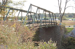
Park's Gap Bridge is a historic Howe Truss bridge located near Martinsburg, at Tomahawk, Berkeley County, West Virginia. It was built in 1892, and has a span 93 feet (28 m) long and 12 feet (3.7 m) wide over Back Creek. It is a simple span pony truss supported on stone abutments.[2]
It was listed on the National Register of Historic Places in 1994.[1]

References[edit]
- ^ a b "National Register Information System". National Register of Historic Places. National Park Service. March 13, 2009.
- ^ Michael Gioulis and Don C. Wood (June 1994). "National Register of Historic Places Inventory Nomination Form: Park's Gap Bridge" (PDF). State of West Virginia, West Virginia Division of Culture and History, Historic Preservation. Retrieved 2011-06-02.
External links[edit]
![]() Media related to Park's Gap Bridge at Wikimedia Commons
Media related to Park's Gap Bridge at Wikimedia Commons
Categories:
- Road bridges on the National Register of Historic Places in West Virginia
- Bridges completed in 1892
- Buildings and structures in Berkeley County, West Virginia
- National Register of Historic Places in Berkeley County, West Virginia
- Berkeley County, West Virginia Registered Historic Place stubs
- Southern United States bridge (structure) stubs
- West Virginia building and structure stubs
- West Virginia transportation stubs


