
Schrankogel
| Schrankogel | |
|---|---|
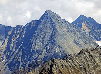
 Schrankogel (centre) and Schrandele (right) with the Schwarzenbergferner glacier seen from the south (Hinterer Daunkopf) | |
| Highest point | |
| Elevation | 3,497 m (AA) (11,473 ft) |
| Prominence | 3,497-2,950 m ↓ Notch between the Schrankogel and the Hinterer Daunkopf |
| Isolation | 9.7 km → Zuckerhütl |
| Listing | Alpine mountains above 3000 m |
| Coordinates | 47°02′41″N 11°05′57″E / 47.04472°N 11.09917°E |
| Geography | |
| Parent range | Stubai Alps |
| Climbing | |
| First ascent | around 1840 by Pastor Schöpf from Gries im Sulztal along the western arête |
| Normal route | Gries – Amberger Hut – Hohes Egg - Schrankogel |

The Schrankogel, 3497 m (called the Schrankogl on the AV map) is the second highest mountain in the Stubai Alps. The northeast side of the Schrankogel is steep and snowy; from all other sides the Schrankogel has a rocky character.
-
 The Schrankogel (left) seen from the Ruderhofspitze, the formerly entirely firn-covered north flank is becoming increasingly snow-free
 -
 The Schrankogel from the west (Hohe Geige)


-
 View looking WSW from the Wildgrat Scharta, showing the Northeast face and the East ridge
 -
 View from halfway up the eastern arête leading to the Ruderhofspitze


| International | |
|---|---|
| National | |