Tiểu Cần district
You can help expand this article with text translated from the corresponding article in Vietnamese. (March 2009) Click [show] for important translation instructions.
|
Tiểu Cần district
Huyện Tiểu Cần | |
|---|---|
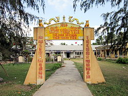
 Vinh Yen communal gate in Tra Vinh City, Vietnam. The house was hidden by a school behind. In the communal house there is an altar of Bo Chanh Tran Trung Tien (or Tran Tuyen). | |
 | |
| Country | |
| Region | Mekong Delta |
| Province | Trà Vinh |
| Capital | Tiểu Cần |
| Area | |
| • Total | 80 sq mi (220 km2) |
| Population (2003) | |
| • Total | 108,718 |
| Time zone | UTC+7 (UTC + 7) |
Tiểu Cần is a rural district of Trà Vinh province in the Mekong Delta region of Vietnam. As of 2003 the district had a population of 108,718.[1] The district covers an area of 220 km2. The district capital lies at Tiểu Cần.[1]
References[edit]
- ^ a b "Districts of Vietnam". Statoids. Retrieved March 13, 2009.

