
Gjeravica
This article needs additional citations for verification. (September 2011) |
| Đeravica | |
|---|---|
| Gjeravica | |
 Đeravica. | |
| Highest point | |
| Elevation | 2,656 m (8,714 ft) |
| Isolation | 28.71 km (17.84 mi) |
| Listing | Country high point |
| Naming | |
| Pronunciation | pronunciation Serbo-Croatian pronunciation: [dʑɛraʋitsa] Albanian pronunciation: [ɟɛɾavitsa] |
| Geography | |
 Đeravica Location of Đeravica (on the Serbian-Albanian border). | |
| Location | Serbia[a] |
| Parent range | Prokletije |
Đeravica (Serbian Cyrillic: Ђеравица, Albanian: Gjeravica) is the second highest mountain peak in the Prokletije region and the Dinaric Alps chain. It has an altitude of 2,656 m (8,714 ft), although it could be 2,667 metres (8,750 ft) as new GPS readings say.[citation needed]. Its precise location occupies a region shrouded in political controversy concerning sovereignty, as it forms a part of a national border to which the legal status is subject to dispute. The Republic of Kosovo[a] views this region where Đeravica lies as forming its national border with Albania. Serbia in turn considers the territory of Kosovo an integral part of its land and therefore recognises the region where Đeravica lies as being Albania's border with Serbia.
National importance
Between 1992 and 2006, it was the highest mountain peak in the Federal Republic of Yugoslavia, and then in the State Union of Serbia and Montenegro.[1] It is the highest point in Kosovo for all purposes regarding the entity but ranks second in Albania with which it shares its peak.
Features
It is somewhat different from the rest of the Prokletije mountains because of the lack of a stony, limestone texture the mountains in Prokletije have.[citation needed] Many large and small glacial lakes can be found near the summit. The largest of the lakes is Đeravica Lake which is just under the summit and is the origin of the Erenik river.
Đeravica and the Prokletije are mostly known for the growth of Chestnuts.[citation needed] There are also wild strawberries growing in Đeravica during the summer.[citation needed]
Geography
Nearby settlements
Nearby Peaks
- Kumulore
- Tropojske Pločice
- Guri i Gjate
- Maja e Ram Arućit
- Ljogi i Prelš
Cliffs
- Biga Tamas
- Krši i Ćenit
- Kumulore
- Krši i Zi
- Guri i Mal
- Gurt e Ljove
- Brehov
- Minarja
Nearby Springs
- Kroni Tedel
- Kroni Gusija
- Kroni i Lizit
- Kroni i Nuses
- Gura e Hasanags
- Kroni i Metes
- Gura e Mir
- Kroni i Rasave
- Kroni i Smajlit
- Gura i Ćuršis
- Gura Hođs
- Kroni i Mir
Gallery
-
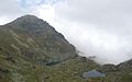
 Glacial lake Đeravica Lake near the summit
 -
 Glacial lakes in Đeravica.
 -
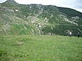 Viewpoint from Đeravica
 -
 Hikers in Đeravica
 -
 Đeravica is a frequented Hiking place.
 -
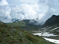 Another Viewpoint from Đeravica
 -
 Erenik river near the springs in Đeravica
 -
 Picture of the lakes


Notes and references
Notes:
| a. | ^ Template:Kosovo-note |
References:
- ^ Official Web Site of the Serbian Government. Facts about Serbia: Position, Relief, Climate. – Retrieved on 24 December 2008.
External links