Hořice
Appearance
Hořice
Hořice v Podkrkonoší | |
|---|---|
Town | |
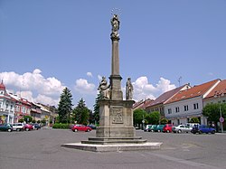
 George of Poděbrady Square | |
| Coordinates: 50°22′3″N 15°37′53″E / 50.36750°N 15.63139°E | |
| Country | |
| Region | Hradec Králové |
| District | Jičín |
| First mentioned | 1143 |
| Government | |
| • Mayor | Aleš Svoboda |
| Area | |
| • Total | 21.46 km2 (8.29 sq mi) |
| Elevation | 311 m (1,020 ft) |
| Population (2020-01-01[1]) | |
| • Total | 8,533 |
| • Density | 400/km2 (1,000/sq mi) |
| Time zone | UTC+1 (CET) |
| • Summer (DST) | UTC+2 (CEST) |
| Postal code | 508 01 |
| Website | www |
Hořice (Czech pronunciation: [ˈɦor̝ɪtsɛ], Template:Lang-de, also known as Hořice v Podkrkonoší) is a town in the Hradec Králové Region of the Czech Republic. It has around 8,500 inhabitants.
Administrative parts
Villages Březovice, Chlum, Chvalina, Doubrava, Libonice and Svatogothardská Lhota are administrative parts of Hořice.
Economy
The town is well known for its production of Hořické trubičky, which is a traditional confectionery. The manufactory is protected by the European Union (PGI).[2]
Notable people
- Iacob Felix (1832–1905), Jewish doctor
- Fritz Mauthner (1849–1923), Jewish writer, philosopher
- Bohumir Kryl (1875–1961), Czech-American cornetist, bandleader, financial executive and art collector
- Karel Vik (1883–1964), painter
- Josef Matoušek (1906–1939), historian
Twin towns – sister cities
References
- ^ "Population of Municipalities – 1 January 2020". Czech Statistical Office. 2020-04-30.
- ^ http://www.horicketrubicky.eu/sdruzeni-vyrobcu-horickych-trubicek.php
- ^ "Úvodní strana". horice.org (in Czech). Město Hořice. Retrieved 2020-09-09.
External links
- Official website (in Czech)
- virtual show


