Middlesex County, Jamaica
Middlesex | |
|---|---|
 | |
| Country | Jamaica |
| County town | Spanish Town |
| Established | 1758 |
| Named for | Middlesex, England |
 |
|---|
|
|
Middlesex is the central of the three historic counties into which Jamaica is divided. It has no current-day administrative significance.[citation needed] It covers 5,041.9 km² and has a population of 1,183,361[1] (about 45% of the island's area and population) giving it the largest area and population of the three counties. It includes Spanish Town, the island's original capital.

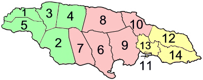
The county of Middlesex is shown in pink.
History
Jamaica's three counties were established in 1L758 to facilitate the holding of courts along the lines of the British County court system.[2] Middlesex, the middle of the three, was named after an English county of the same name. It was chosen in Jamaica presumably because of its central position.[2] Spanish Ton was its county town.[2]
Parishes
| Middlesex County | ||||
| On map |
Parish | Area km² |
Population Census 2011 |
Capital |
| 6 | Clarendon | 1,196.3 | 237,024 | May Pen |
| 7 | Manchester | 830.1 | 185,801 | Mandeville |
| 8 | Saint Ann | 1,212.6 | 166,762 | Saint Ann's Bay |
| 9 | Saint Catherine | 1,192.4 | 482,308 | Spanish Town |
| 10 | Saint Mary | 610.5 | 111,466 | Port Maria |
| Middlesex County | 5,041.9 | 1,183,361 | ||
| Jamaica total | 10,990.5 | 2,607,631 | Kingston | |
