Bussum
Bussum | |
|---|---|
Town and former municipality | |
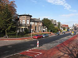
 Bussum across from city hall | |
 Location in North Holland | |
| Coordinates: 52°17′N 5°10′E / 52.283°N 5.167°E | |
| Country | Netherlands |
| Province | North Holland |
| Municipality | Gooise Meren |
| Area | |
• Total | 8.15 km2 (3.15 sq mi) |
| • Land | 8.09 km2 (3.12 sq mi) |
| • Water | 0.06 km2 (0.02 sq mi) |
| Elevation | 1 m (3 ft) |
| Population (2019)[3] | |
• Total | 33,595 |
| • Density | 4,100/km2 (11,000/sq mi) |
| Demonym | Bussumer |
| Time zone | UTC+1 (CET) |
| • Summer (DST) | UTC+2 (CEST) |
| Postcode | 1400–1406 |
| Area code | 035 |
| Website | www |
 Bussum (Dutch pronunciation: [ˈbɵsəm] ) is a commuter town and former municipality in the Het Gooi region in the south east of the province of North Holland in the Netherlands near Hilversum. Since 2016, Bussum has been part of the new municipality of Gooise Meren.
Bussum had a population of 33,595 in 2019 and covered an area of 8.15 km2 (3.15 sq mi).
History
For a long time Bussum was not more than a hamlet situated amongst the heathlands of Het Gooi and was first mentioned in 1306. In this time, Bussum was a large heathland with many small farms, sheep pens and forests as is shown on old maps. Since Bussum is situated near the fortified town Naarden it was governed by Naarden from 1369 onward. In 1470 Bussum was inhabited by about 250 people, which made it the smallest village in Het Gooi.
Bussum became independent from Naarden in 1817, yet it was not until the arrival of a railway line in 1874 that Bussum began to flourish. Two train stations were built in the town, that still exist today: Naarden-Bussum and Bussum Zuid (Dutch for Bussum South), both on the connection between Amsterdam and Hilversum. The stations and the road network fostered the town's status as a satellite town of Amsterdam, allowing for reverse commute also to Hilversum. From 1898 until 1907, Bussum housed the first Dutch socialist colony after the example of Thoreau's Walden, set up by the writer and psychiatrist Frederik van Eeden. In 1951, Bussum hosted the first Dutch national TV broadcast and the national TV studios were located there until 1964.
Bussum was set to merge with the local municipalities of Naarden, Muiden and Muiderberg on 1 January 2016. In October 2014, the combined town councils chose the name Gooise Meren for the new municipality, the other options being Naarden-Bussum and Naardingerland.[4]
Local government
The last municipal council of Bussum consisted of 23 seats, which were divided as follows (2015):
- VVD - 5 seats
- Hart voor Bussum - 4 seats
- PvdA - 3 seats
- CDA - 2 seats
- GroenLinks - 2 seats
- D66 - 2 seats
- Gooise Ouderen Partij - 2 seats
- Partij voor Bussum (PVB) - 1 seat
- Fractie Krabbendam - 1 seat
- GooiDuursaam - 1 seat
Notable residents
- Freddy Wittop (1911–2001) international costume designer
- Karel Thole (1914–2000), painter and illustrator
- Paul Biegel (1925–2006), author
- Willem Duys (1928–2011), radio and television presenter and record producer
- Thierry Veltman (born 1939), artist
- Tineke Lagerberg (born 1941), swimmer
- Ronnie Tober (born 1945), singer and entertainer
- Charles de Lint (born 1951), Canadian author and musician
- Huub Rothengatter (born 1954), racing driver
- Raoul Heertje (born 1963), comedian
- Anneloes Nieuwenhuizen (born 1963), field hockey defender
- E. van der Bovenkampf (born 1964), Professor at the University of Groningen
- Ruud Hesp (born 1965), football goalkeeper
- Ellen Elzerman (born 1971), swimmer
- Thekla Reuten (born 1975), actress
- Wopke Hoekstra (born 1975), Dutch politician
Transport
The town of Bussum has two railway stations: Naarden-Bussum and Bussum Zuid.
References
- ^ "Kerncijfers wijken en buurten 2020" [Key figures for neighbourhoods 2020]. StatLine (in Dutch). CBS. 24 July 2020. Retrieved 19 September 2020.
- ^ "Postcodetool for 1404EP". Actueel Hoogtebestand Nederland (in Dutch). Het Waterschapshuis. Retrieved 25 February 2014.
- ^ "Bevolkingsontwikkeling; regio per maand" [Population growth; regions per month]. CBS Statline (in Dutch). CBS. 1 January 2021. Retrieved 2 January 2022.
- ^ "Gooise Meren wordt de naam van de fusiegemeente Naarden-Muiden-Bussum'" (in Dutch). Archived from the original on 2014-12-24. Retrieved 2014-11-17.
External links
 Media related to Bussum at Wikimedia Commons
 Bussum travel guide from Wikivoyage
- Official website
- A view on the old town of Bussum


