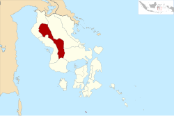
East Kolaka Regency
East Kolaka Regency
Kabupaten Kolaka Timur | |
|---|---|
 Location within Southeast Sulawesi | |
| Coordinates: 3°58′46″S 121°54′00″E / 3.97944°S 121.90000°E | |
| Country | Indonesia |
| Province | Southeast Sulawesi |
| Capital | Tirawuta |
| Government | |
| • Regent | Tony Herbiansyah |
| • Vice Regent | Andi Merya Nur |
| Area | |
| • Total | 3,634.74 km2 (1,403.38 sq mi) |
| Population (2010) | |
| • Total | 106,315 |
| • Density | 29/km2 (76/sq mi) |
| Time zone | UTC+8 (ICST) |
| Postcode | 93573 |
| Area code | (+62) 405 |
The East Kolaka Regency is a new regency of Southeast Sulawesi, Indonesia, established in 2013. The administrative centre lies at Tirawuta; its interim Regent is Tony Herbiansyah. The area is 3,634.74 km², and the estimated population (2013) is 123,507.
Administration
On 14 December 2012, the Indonesian Parliament approved the establishment of a new East Kolaka Regency (Kolaka Timur), to be split off from the existing Kolaka Regency; the new regency - which came into effect in 2013 under Law No. 8 of 2013 - comprises the 9 districts detailed below with their 2010 Census population. The districts are subdivided into 96 villages.
| Name | Population Census 2010 |
|---|---|
| Ladongi | 23,818 |
| Lambadia | 27,893 |
| Poli-Polia | 10,606 |
| Tirawuta | 12,483 |
| Lalolae | 3,542 |
| Loea | 6,174 |
| Mowewe | 7,538 |
| Uluiwoi | 7,242 |
| Tinondo | 7,019 |
| Total for Regency | 106,315 |
References
External links
3°58′46″S 121°54′00″E / 3.97944°S 121.90000°E


