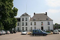
Gerpinnes
Appearance
Gerpinnes | |
|---|---|
 Gerpinnes town hall | |
| Coordinates: 50°20′N 04°31′E / 50.333°N 4.517°E | |
| Country | |
| Community | French Community |
| Region | Wallonia |
| Province | Hainaut |
| Arrondissement | Charleroi |
| Government | |
| • Mayor | Philippe Busine (CDH) |
| • Governing party/ies | CDH, MR |
| Area | |
| • Total | 47.68 km2 (18.41 sq mi) |
| Population (2018-01-01)[1] | |
| • Total | 12,660 |
| • Density | 270/km2 (690/sq mi) |
| Postal codes | 6280 |
| NIS code | 52025 |
| Area codes | 071 |
| Website | www.gerpinnes.be |
Gerpinnes (French pronunciation: [ʒɛʁ.pin]) is a Walloon municipality located in the Belgian province of Hainaut. On 1 January 2006 the municipality had 12,030 inhabitants. The total area is 47.10 km², giving a population density of 255 inhabitants per km².
Every year at Whitsun, a large procession is organised in honour of Saint Rolendis (Sainte Rolende). Participants are dressed as Napoleonic soldiers, and walk about 40 km around the whole municipality.
Villages and towns
- Acoz (site of Acoz Castle)
- Gougnies
- Joncret
- Loverval
- Villers-Poterie

References
- ^ "Wettelijke Bevolking per gemeente op 1 januari 2018". Statbel. Retrieved 9 March 2019.
External links
 Media related to Gerpinnes at Wikimedia Commons
- Website of the administration of Gerpinnes (French)
- Website of the Scouts "Frère Pierre" of Gerpinnes (French)
- Website of the tourism office of Gerpinnes (French-English-Dutch)


