Relizane Province
Appearance
Relizane Province
ولاية غليزان | |
|---|---|
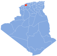
 Map of Algeria highlighting Relizane | |
| Coordinates: 35°44′N 0°33′E / 35.733°N 0.550°E | |
| Country | |
| Capital | Relizane |
| Government | |
| • PPA president | Mr. Benaouda Bettayeb (RND) |
| • Wāli | Mr. Boukarabila Djelloul |
| Area | |
• Total | 4,870 km2 (1,880 sq mi) |
| Population (2008)[1] | |
• Total | 733,060 |
| • Density | 150/km2 (390/sq mi) |
| Time zone | UTC+01 (CET) |
| Area Code | +213 (0) 46 |
| ISO 3166 code | DZ-48 |
| Districts | 13 |
| Municipalities | 38 |

Relizane (Template:Lang-ar) is a province (wilaya) of Algeria. Relizane is the capital. Other localities include Bendaoud, Bouzegza, Hamri, Kalaa, Mazouna and Zemmoura. The Wilaya of Relizane massacres of 4 January 1998 happened in Relizane.
History
The province was created from Mostaganem Province in 1984.
Administrative divisions
The province is divided into 13 districts (daïras), which are further divided into 38 communes or municipalities.
Districts (daïras)
Communes
- Aïn Rahma
- Ain Tarik
- Ammi Moussa
- Belassel Bouzegza
- Bendaoud
- Beni Dergoun
- Beni Zentis
- Dar Ben Abdellah
- Djidioua
- El Guettar
- El H'Madna
- El Hamri
- El Hassi
- El Matmar
- El Ouldja
- Had Echkalla
- Kalaa
- Lahlef
- Mazouna
- Mediouna
- Mendes
- Merdja Sidi Abed
- Ouarizane
- Oued Essalem
- Oued Rhiou
- Ouled Aiche
- Ouled El Djemaa
- Ouled Sidi Mihoub
- Ramka
- Relizane
- Sidi Khettab
- Sidi Lazreg
- Sidi M'Hamed Ben Ali
- Sidi M'Hamed Benaouda
- Sidi Saada
- Souk El Had
- Yellel
- Zemmoura
References
Wikimedia Commons has media related to Relizane Province.
- ^ Office National des Statistiques, Recensement General de la Population et de l’Habitat 2008 Archived 2008-07-24 at the Wayback Machine Preliminary results of the 2008 population census. Accessed on 2008-07-02.


