Kcynia
Kcynia | |
|---|---|
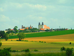
 Skyline of Kcynia with the Baroque Church of the Assumption of Mary | |
| Coordinates: 52°59′31″N 17°29′4″E / 52.99194°N 17.48444°E | |
| Country | |
| Voivodeship | Kuyavian-Pomeranian |
| County | Nakło |
| Gmina | Kcynia |
| Area | |
| • Total | 6.84 km2 (2.64 sq mi) |
| Population (2006) | |
| • Total | 4,679 |
| • Density | 680/km2 (1,800/sq mi) |
| Time zone | UTC+1 (CET) |
| • Summer (DST) | UTC+2 (CEST) |
| Postal code | 89-240 |
| Website | http://www.kcynia.pl |
Kcynia [ˈkt͡sɨɲa] (German: Exin) is a town in Nakło County, Kuyavian-Pomeranian Voivodeship, Poland, with 4,712 inhabitants (2004). It is located in the Pałuki ethnographic region in the northern part of historic Greater Poland.
History

Kcynia started in the Middle Ages, with the rule of the founding Piast dynasty in Poland. In the 11th century, Polish ruler Władysław Herman built a church of St. Giles at the site.[1] In 1255 Kcynia was owned by Duke of Greater Poland Przemysł I.[1] His brother, Duke Bolesław the Pious, in 1262 granted Kcynia town rights along with privileges similar to those enjoyed by Poznań and Gniezno.[2] Kcynia was a royal town of the Polish Crown and a county seat in the Kalisz Voivodeship in the Greater Poland Province of the Polish Crown.[3] The coat of arms of Kcynia depicts the white eagle of Greater Poland.[4] Kcynia suffered a fire in 1441.[2] The town had defensive walls and a castle, which was the seat of local starosts (local royal administrators). In 1594 Polish King Sigismund III Vasa visited the town, while returning from Sweden.[2] From 1768 Kcynia was part of the newly established Gniezno Voivodeship in the Greater Poland Province.[3]
Kcynia was annexed by Prussia in the First Partition of Poland in 1772.[2] In 1807 it became part of the short-lived Polish Duchy of Warsaw, and in 1815 it was re-annexed by Prussia.[5] During the Greater Poland uprising (1848), it was the site of the Battle of Kcynia, in which Polish insurgents won against the Prussians. The town was attacked on the night of May 7, 1848, led by several Polish nobles. On this occasion around 40 people lost their lives, the town was set on fire in three places, and the German inhabitants were plundered under the pretext of disarmament. In 1867 a post office building was built. In 1871, the town became part of the German Empire, as part of the Prussian Province of Posen. In 1888 Exin was connected to the German rail network from Gnesen (Gniezno) to Nakel (Nakło nad Notecią). Similar to the school strike in Wreschen, there was a strike in the school year 1906/1907 when German was introduced as a compulsory language for religious instruction. In 1908 the rail network was expanded and the city received rail connections to Bromberg (Bydgoszcz) and Posen (Poznań). In 1913 the construction of the station building was completed.
According to the German census of 1890, the town had a population of 2,814, of which 1,650 (58.6%) were Poles.[6] In 1913, the town had a population of 4,000, including 3,000 Roman Catholics, 800 Protestants, and 200 Jews.[7] The populace took part in the Greater Poland uprising (1918–19),[5] and at the end of the First World War, the town came to the Second Polish Republic in 1919 and officially on January 10, 1920 due to the Versailles Treaty. Many German and Jewish inhabitants left the town in the interwar-period. In the 1938 Polish census, of the 4,554 inhabitants, 4,159 were Polish, 327 declared German ethnicity and only 68 were Jewish.
During World War II, Kcynia was under German occupation from 1939 to 1945. The Germans carried out massacres and expulsions of Poles[5] to the General Government. In December 1939 and August 1940, Germans expelled Polish intelligentsia with their families, as well as owners of better houses, workshops and shops, which were then handed over to German colonists as part of the Lebensraum policy.[8] Further expulsions were carried out in February 1941.[9] In 1939, the Jewish synagogue was destroyed by the Wehrmacht.[7]
Sights
The main landmarks of Kcynia are the Carmelite monastery with the Baroque Church of the Assumption of Mary, and the Gothic Saint Michael Archangel church.
Notable residents
- Bernadetta Blechacz (1955- ), Polish Olympian javelin thrower
- Ismar Isidor Boas (1858-1938), German-Jewish gastroenterologist
- Jan Czochralski (1885-1953), Polish chemist
- Otto Krümmel (1854-1912), German geographer
- Klara Prillowa (1907-1991), Polish sculptor, folklorist and ethnographer
- Mieczysław Rakowski (1926-2008), Polish communist politician and Prime Minister
References
- ^ a b Tadeusz Pietrykowski, Z przeszłości Kcyni z okazji 666 rocznicy założenia miasta, Kcynia, 1928, p. 16 (in Polish)
- ^ a b c d Słownik geograficzny Królestwa Polskiego i innych krajów słowiańskich, Tom III, Warszawa, 1882, p. 947 (in Polish)
- ^ a b Pietrykowski, p. 27
- ^ Pietrykowski, p. 18-19
- ^ a b c "Kcynia". Encyklopedia PWN (in Polish). Retrieved 11 July 2020.
- ^ "Deutsche Verwaltungsgeschichte Provinz Posen, Kreis Schubin". treemagic.org. Retrieved 2021-01-19.
- ^ a b Aronsfeld, C. C. (1997). Wanderer From My Birth. London: Janus Publishing. pp. 9, 12. ISBN 9781857563559. OCLC 39275680.
- ^ Maria Wardzyńska, Wysiedlenia ludności polskiej z okupowanych ziem polskich włączonych do III Rzeszy w latach 1939-1945, IPN, Warszawa, 2017, p. 178, 240 (in Polish)
- ^ Wardzyńska, p. 301


