Klaaskreek
Klaaskreek | |
|---|---|
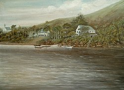
 Berg en Dal (1885) | |
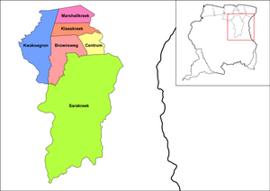
 Map showing the resorts of Brokopondo District. Klaaskreek | |
| Coordinates: 5°10′50″N 55°4′35″W / 5.18056°N 55.07639°W | |
| Country | |
| District | Brokopondo District |
| Area | |
• Total | 349 km2 (135 sq mi) |
| Population (2012)[1] | |
• Total | 2,124 |
| • Density | 6.1/km2 (16/sq mi) |
| Time zone | UTC-3 (AST) |
Klaaskreek is a resort in Suriname, located in the Brokopondo District. Its population at the 2012 census was 2,124.[1] Located northeast of Brokopondo, the main town is Reinsdorp. In 2007, a technical training centre in biological agriculture was established at Klaaskreek to teach locals about enhancing agriculture in the area.[2]
History
Around 1860 an expedition led by J. Rosenberg set out to discover gold. Even though some gold was discovered near Victoria, the government decided not pursue the matter. Rosenberg however persisted, established the New-York and Surinam Company, and finally received a concession in 1870. The company failed it meet its objectives, and the concession was nullified in 1874.[3]
Klaaskreek is situated in the proximity of the Brokopondo Reservoir. In 1958 Klaaskreek was designated as one of the transmigration towns for the inhabitants of the area that was flooded after the construction of the Afobaka Dam,[4] and the main settlement for people from Ganzee.[5] Klaaskreek is a tribal[4] area mainly inhabited by Maroons.[1]
Klaaskreek has a school, police station,[4] civil engineering company.,[6] river resort,[7] and a beach called Benastrand.[8] Medische Zending operates a clinic in the town.[9]
Towns
Other villages in the resort include Berg en Dal, Kapasikélé, Njun Lombe, Mujékiki, and Reinsdorp.[4] In 1960, an agriculture pilot project was started in Brokobaka, Centrum.[10] The project led to a palm oil plantation and factory in the former plantation of Victoria.[11] however the Surinamese Interior War and lethal yellowing resulted in the closure of the factory in 1996.[12]

References
- ^ a b c "Resorts in Suriname Census 2012" (PDF). Retrieved 15 May 2020.
- ^ "United Nations Development Programme". Archived from the original on 2011-07-23. Retrieved 2010-01-26.
- ^ "Encyclopaedie van Nederlandsch West-Indië - Page 312 - Goudindustrie" (PDF). Digital Library for Dutch Literature (in Dutch). 1916. Retrieved 15 May 2020.
- ^ a b c d "Onderzoek Regionaal plan Bronsweg 2015-2040" (PDF). Planning Office Suriname (in Dutch). Retrieved 12 May 2020.
- ^ "Nostalgie en toch toekomstgericht denken en handelen". Suriname Herald (in Dutch). Retrieved 15 February 2021.
- ^ "Surinaams dorpje baalt van 'smerig' bedrijf". Waterkant.net (in Dutch). Retrieved 15 May 2020.
- ^ "New Babunhol River Resort". Trip Advisor. Retrieved 15 May 2020.
- ^ "Klaaskreek". Surivision (in Dutch). Retrieved 15 May 2020.
- ^ "Zorggebied". Medische Zending.sr (in Dutch). Retrieved 15 May 2020.
- ^ "Distrikt Brokopondo". Suriname.nu (in Dutch). Retrieved 15 May 2020.
- ^ "Plantages / P / Phedra". Suriname Plantages. Retrieved 15 May 2020.
- ^ "Oliepalmproductie zou geen prioriteit moeten zijn". Dagblad Suriname (in Dutch). Retrieved 15 May 2020.

