Bojnord County
Appearance
Bojnord County
| |
|---|---|
County | |
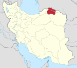
 Location of Bojnord County in North Khorasan province | |
 Location of North Khorasan province in Iran | |
| Coordinates: 37°37′N 57°22′E / 37.617°N 57.367°E[1] | |
| Country | Iran |
| Province | North Khorasan |
| Capital | Bojnord |
| Districts | Central, Garmkhan |
| Population (2016)[2] | |
• Total | 324,083 |
| Time zone | UTC+3:30 (IRST) |
| Bojnord County at GEOnet Names Server | |
Bojnord County (Template:Lang-fa) is in North Khorasan province, Iran. Its capital is the city of Bojnord.
At the 2006 census, the county's population was 322,309 in 79,882 households.[3] The following census in 2011 counted 365,896 people in 100,900 households.[4] At the 2016 census, the county's population was 324,083 in 94,457 households, by which time Raz and Jargalan District had been separated from the county to form Raz and Jargalan County.[2]
Administrative divisions
The population history and structural changes of Bojnord County's administrative divisions over three consecutive censuses are shown in the following table. The latest census shows two districts, five rural districts, and three cities.[2]
| Administrative Divisions | 2006[3] | 2011[4] | 2016[2] |
|---|---|---|---|
| Central District | 238,632 | 279,872 | 300,082 |
| Aladagh Rural District | 26,259 | 32,494 | 28,218 |
| Baba Aman Rural District | 19,323 | 24,187 | 15,609 |
| Badranlu Rural District | 20,278 | 23,400 | 23,944 |
| Bojnord (city) | 172,772 | 199,791 | 228,931 |
| Chenaranshahr (city) | 3,380 | ||
| Garmkhan District | 28,259 | 26,955 | 24,001 |
| Garmkhan Rural District | 17,104 | 15,720 | 13,844 |
| Gifan Rural District | 10,439 | 9,577 | 8,658 |
| Hesar-e Garmkhan (city) | 716 | 1,658 | 1,499 |
| Raz and Jargalan District1 | 55,418 | 59,034 | |
| Gholaman Rural District | 13,965 | 14,813 | |
| Jargalan Rural District | 30,659 | 32,981 | |
| Raz Rural District | 6,059 | 5,493 | |
| Raz (city) | 4,735 | 5,747 | |
| Total | 322,309 | 365,896 | 324,083 |
| 1Became a part of Raz and Jargalan County | |||
Wikimedia Commons has media related to Bojnord County.
References
- ^ OpenStreetMap contributors (17 May 2023). "Bojnord County" (Map). OpenStreetMap. Retrieved 17 May 2023.
- ^ a b c d "Census of the Islamic Republic of Iran, 1395 (2016)". AMAR (in Persian). The Statistical Center of Iran. p. 28. Archived from the original (Excel) on 27 October 2020. Retrieved 19 December 2022.
- ^ a b "Census of the Islamic Republic of Iran, 1385 (2006)". AMAR (in Persian). The Statistical Center of Iran. p. 28. Archived from the original (Excel) on 20 September 2011. Retrieved 25 September 2022.
- ^ a b "Census of the Islamic Republic of Iran, 1390 (2011)" (Excel). Iran Data Portal (in Persian). The Statistical Center of Iran. p. 28. Retrieved 19 December 2022.

