Yesan County
Appearance
This article needs additional citations for verification. (September 2018) |
Yesan
예산군 | |
|---|---|
| Korean transcription(s) | |
| • Hangul | 예산군 |
| • Hanja | 禮山郡 |
| • Revised Romanization | Yesan-gun |
| • McCune-Reischauer | Yesan-gun |
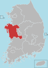
 Location in South Korea | |
| Country | South Korea |
| Region | Hoseo |
| Administrative divisions | 2 eup, 10 myeon |
| Area | |
• Total | 542.65 km2 (209.52 sq mi) |
| Population (2022) | |
• Total | 76,651 |
| • Density | 141.25/km2 (365.8/sq mi) |
| • Dialect | Chungcheong |
Yesan (Korean: [je.san]) is a county in South Chungcheong Province, South Korea. Famous people from Yesan include independence fighter Yoon Bong-Gil.
Sudeoksa, a head temple of the Jogye Order of Korean Buddhism, is located on the southern slopes of Deoksungsan in Deoksan-myeon, Yesan County. Its main hall is daeungjeon (大雄殿), Korea's oldest wooden building and National Treasure 49.
In 2009, Yesan was designated a "slow city," one in which traditional cultures and communities are preserved.[1]
Climate
Yesan has a humid continental climate (Köppen: Dwa), but can be considered a borderline humid subtropical climate (Köppen: Cwa) using the −3 °C (27 °F) isotherm.
| Climate data for Yesan (1993–2020 normals) | |||||||||||||
|---|---|---|---|---|---|---|---|---|---|---|---|---|---|
| Month | Jan | Feb | Mar | Apr | May | Jun | Jul | Aug | Sep | Oct | Nov | Dec | Year |
| Mean daily maximum °C (°F) | 2.8 (37.0) |
5.7 (42.3) |
11.9 (53.4) |
18.7 (65.7) |
24.4 (75.9) |
28.3 (82.9) |
30.1 (86.2) |
31.1 (88.0) |
26.8 (80.2) |
20.9 (69.6) |
12.9 (55.2) |
5.0 (41.0) |
18.2 (64.8) |
| Daily mean °C (°F) | −2.1 (28.2) |
0.2 (32.4) |
5.4 (41.7) |
11.9 (53.4) |
17.9 (64.2) |
22.4 (72.3) |
25.6 (78.1) |
26.2 (79.2) |
21.2 (70.2) |
14.3 (57.7) |
7.2 (45.0) |
0.1 (32.2) |
12.5 (54.5) |
| Mean daily minimum °C (°F) | −6.6 (20.1) |
−4.7 (23.5) |
−0.2 (31.6) |
5.8 (42.4) |
12.2 (54.0) |
17.6 (63.7) |
22.0 (71.6) |
22.4 (72.3) |
16.5 (61.7) |
8.7 (47.7) |
2.1 (35.8) |
−4.4 (24.1) |
7.6 (45.7) |
| Average precipitation mm (inches) | 19.6 (0.77) |
25.6 (1.01) |
36.7 (1.44) |
67.8 (2.67) |
74.0 (2.91) |
128.6 (5.06) |
270.8 (10.66) |
253.0 (9.96) |
157.8 (6.21) |
52.7 (2.07) |
48.0 (1.89) |
23.6 (0.93) |
1,158.2 (45.60) |
| Average precipitation days (≥ 0.1 mm) | 4.3 | 3.6 | 5.0 | 6.1 | 6.0 | 6.6 | 12.4 | 12.0 | 7.1 | 4.7 | 7.1 | 6.8 | 81.7 |
| Source: Korea Meteorological Administration[2] | |||||||||||||
Transportation
Sister cities
Domestic
International
Notable people
- Park Hyo-shin; singer
- Yun Dae-nyeong; Author
- Yun Bong-gil; fighter for independence
- Baek Jong-won; food researcher, businessman, entertainer.
See also
References
- ^ Korea Tourism Organization (n.d.). Korea Travel Guide. KTO. p. 81.
- ^ "Climatological Normals of Korea (1991 ~ 2020)" (PDF) (in Korean). Korea Meteorological Administration. Archived from the original (PDF) on 29 January 2022. Retrieved 7 June 2023.
External links
36°40′45″N 126°50′42″E / 36.6791666767°N 126.84500001°E


