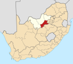
Wolmaransstad
This article needs additional citations for verification. (September 2014) |
Wolmaransstad | |
|---|---|
 DR Church in Wolmaransstad | |
| Coordinates: 27°13′0″S 25°58′28″E / 27.21667°S 25.97444°E | |
| Country | South Africa |
| Province | North West |
| District | Dr Kenneth Kaunda |
| Municipality | Maquassi Hills |
| Area | |
• Total | 41.68 km2 (16.09 sq mi) |
| Population (2011)[1] | |
• Total | 3,633 |
| • Density | 87/km2 (230/sq mi) |
| Racial makeup (2011) | |
| • Black African | 35.4% |
| • Coloured | 2.6% |
| • Indian/Asian | 2.8% |
| • White | 57.4% |
| • Other | 1.8% |
| First languages (2011) | |
| • Afrikaans | 71.6% |
| • Tswana | 13.0% |
| • English | 8.2% |
| • Sotho | 2.5% |
| • Other | 4.7% |
| Time zone | UTC+2 (SAST) |
| Postal code (street) | 2630 |
| PO box | 2630 |
| Area code | 018 |
Wolmaransstad (Afrikaans for "Wolmarans City") is a maize-farming town situated on the N12 between Johannesburg and Kimberley in North West Province of South Africa. The town lies in an important alluvial diamond-mining area and it is the main town of the Maquassi Hills Local Municipality.
Town 245 km south-west of Johannesburg and 56 km north-east of Bloemhof. It was laid out on the farms Rooderand and Vlakfontein in 1888, and proclaimed a town in 1891. Named after Jacobus M. A. Wolmarans, then member of the Executive Council.[2]
Wolmaransstad originated in 1891 on the banks of the Makwasi River (San word for a type of wild spearmint) and takes its name from J. M. A. Wolmarans, a volksraad councilman.
Wolmaransstad serves a large community and is an important diamond buying center.
The Dutch Reformed church building was designed by Gerard Moerdijk.
Anglo Boer war
This section is empty. You can help by adding to it. (April 2022) |
Tourist attractions
- Broadbent Mission Station [3]
- Digger's Diamond route [4]
- Makwassierante Conservation Area
- Wolwespruit Dam Nature Reserve
Notable native
- Bernardus Gerhardus Fourie (also known as Brand Fourie; 1916–2008), South African politician
See also
- Wolmaransstad Commando, a former light infantry regiment of the South African Army based in Wolmaransstad
References
- ^ a b c d "Main Place Wolmaransstad". Census 2011.
- ^ "Dictionary of Southern African Place Names (Public Domain)". Human Science Research Council. p. 480.
- ^ "Wolmaransstad". Tourism North West. Retrieved 11 February 2021.
- ^ "Wolmaransstad, Southern Region". SA Venues. Retrieved 11 February 2021.


