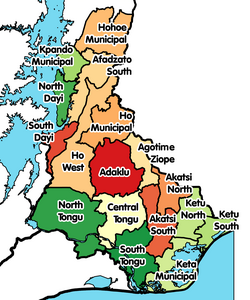
Ketu South Municipal District
Ketu South Municipal Assembly | |
|---|---|
Municipal District | |
 Districts of Volta Region | |
Location of Ketu South Municipal District within Volta | |
| Coordinates: 6°0′0.36″N 0°35′56.76″E / 6.0001000°N 0.5991000°E | |
| Country | |
| Region | |
| Capital | Denu |
| Government | |
| • Municipal Chief Executive | Hon. Pascal Lamptey[1] |
| Area | |
| • Total | 254 km2 (98 sq mi) |
| Population (2021[2]) | |
| • Total | 253,122 |
| • Density | 1,000/km2 (2,600/sq mi) |
| Time zone | UTC+0 (GMT) |
| ISO 3166 code | GH-TV-KS |
| Website | www |
Ketu South Municipal Assembly formerly Ketu South District, is one of the eighteen districts in Volta Region, Ghana.[3] Originally it was formerly part of the then-larger Ketu District on 10 March 1989, which was created from the former Anlo District Council, until the northern part of the district was split off to create Ketu North District on 29 February 2008; thus the remaining part has been renamed as Ketu South District. It was later elevated to municipal district assembly status on 28 June 2012 to become Ketu South Municipal District. The municipality is located in the southeast corner of Volta Region, immediately adjacent to the city of Lomé in Togo to the east, and has Denu as its capital town. The Municipality is known to be the largest Kente Production Hub in Ghana.
Geography

The district is bounded by Togo to the east, the Gulf of Guinea to the south, Keta Municipal District to the west and Ketu North District to the north.[4]
Settlements
The largest settlements in the district are Aflao, Avoeme, Klikor, Pernyi, and Agbozume.[5] Other settlements include Salakope, Adina, Denu, Sonuto, Blekusu, Adafienu, Nogokpoe, Agavedzi and Amutsinu.[6]
Elections
In the 2016 general elections, this constituency has been listed as the topmost one by voter population with over 141,698 registered voters.[7]
References
- ^ "Lamptey Endorsed As Ketu-South MCE". Ghana News Agency. 29 October 2013. Retrieved 27 December 2014.
- ^ Ghana: Administrative Division
- ^ "Controversy in Ketu South as Municipal Assembly nominates new government appointees to approve president's DCE nominee". myjoyonline.com. 27 October 2013. Retrieved 27 December 2014.
- ^ "about this municipality". ketusouth.ghanadistricts.gov.gh. Archived from the original on 8 October 2014. Retrieved 27 December 2014.
- ^ "Ketu South Municipal Assembly - Demographic Characteristics - Population & Housing". Ghana Districts. 21 December 2017. Retrieved 11 June 2020.
- ^ "Agavedzi residents call for support after tidal waves render 700 homeless - MyJoyOnline.com". www.myjoyonline.com. Retrieved 2021-05-29.
- ^ "Top 10 constituencies by voter population [Infographic]". 22 November 2016.


