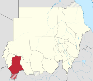
South Darfur
Appearance
South Darfur State
ولاية جنوب دارفور Janob Darfor | |
|---|---|
 South Darfur | |
 Location in Sudan | |
| Coordinates: 11°31′N 25°2′E / 11.517°N 25.033°E | |
| Country | |
| Region | Darfur |
| Capital | Nyala |
| Government | |
| • Governor | Musa Mahdi Ishaq |
| Area | |
| • Total | 127,300 km2 (49,200 sq mi) |
| Population (2018) | |
| • Total | 5,353,025[1] |
| Time zone | UTC+2 (CAT) |
| HDI (2017) | 0.434[2] low |
| Website | Official website |
South Darfur State (Arabic: ولاية جنوب دارفور Wilāyat Ǧanūb Dārfūr; Janob Darfor) is one of the wilayat or states of Sudan. It is one of the five states that compose the region of Darfur in western Sudan.
Overview

Prior to the creation of two new states in the Darfur region in January 2012, South Darfur had an area of 127,300 square kilometres (49,200 sq mi) and an estimated population of approximately 2,890,000 (2006). Nyala is the capital of the state. The State was affected by the 2010 Sahel famine.
References
- ^ "Archived copy" (PDF). Archived from the original (PDF) on 2017-03-12. Retrieved 2023-06-09.
{{cite web}}: CS1 maint: archived copy as title (link) - ^ "Sub-national HDI - Area Database - Global Data Lab". hdi.globaldatalab.org. Retrieved 2018-09-13.
External links


