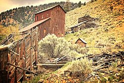
Bayhorse, Idaho
Appearance
Bayhorse | |
 | |
| Location | Custer County, Idaho |
|---|---|
| Nearest city | Challis, Idaho |
| Coordinates | 44°23′52″N 114°18′42″W / 44.39778°N 114.31167°W |
| Built | 1877 |
| NRHP reference No. | 76000671[1] |
| Added to NRHP | March 15, 1976 |
Bayhorse is a ghost town in Custer County, Idaho, United States, founded in 1877.[1][2] After a new gold mine failed, silver was discovered in the area and a mine was started. Bayhorse was originally established by the silver mine.[citation needed]
In 1976, the entire community was added to the National Register of Historic Places.[1] The town property was purchased by the state in 2006 and opened to the public in 2009 as part of the Land of the Yankee Fork State Park.[3]
Remains
You can walk along the main dirt street and see several preserved ruins of houses and mining equipment. Also intact are charcoal kilns used to make charcoal to smelt the ore from the mines.[4]
References
- ^ a b c "National Register Information System". National Register of Historic Places. National Park Service. April 15, 2008.
- ^ Weis, Norman D. (1971). Ghost Towns of the Northwest. Caldwell, Idaho, USA: Caxton Press. ISBN 0-87004-358-7.
- ^ The Idaho Statesman [dead link]
- ^ "Bayhorse Ghost Town and Trails System".
External links
![]() Media related to Bayhorse, Idaho at Wikimedia Commons
Media related to Bayhorse, Idaho at Wikimedia Commons
- Land of the Yankee Fork State Park
- Bay Horse and Clayton, Idaho State Historical Society Reference Series
Categories:
- Populated places established in 1877
- Populated places in Custer County, Idaho
- Ghost towns in Idaho
- Protected areas of Custer County, Idaho
- National Register of Historic Places in Custer County, Idaho
- Populated places on the National Register of Historic Places in Idaho
- 1877 establishments in Idaho Territory
- Custer County, Idaho, geography stubs
- Idaho Registered Historic Place stubs
- United States ghost town stubs


