Kfar Ma'as
Appearance
Kfar Ma'as
כְּפַר מַעַשׂ | |
|---|---|
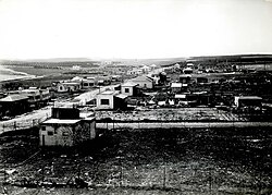
 Kfar Ma'as in 1938 | |
| Coordinates: 32°3′49″N 34°53′25″E / 32.06361°N 34.89028°E | |
| Country | Israel |
| District | Central |
| Council | Drom HaSharon |
| Affiliation | Moshavim Movement |
| Founded | 1934 |
| Population (2022)[1] | 826 |
| Website | www |
Kfar Ma'as (Hebrew: כְּפַר מַעַשׂ, lit. 'Deed Village') is a moshav in central Israel. Located to the south of Petah Tikva on the edge of the Ono Valley, it falls under the jurisdiction of Drom HaSharon Regional Council. In 2022 it had a population of 826.[1]
History
The moshav was formed in 1934 by the uniting of two villages, Behadraga and HaYovel.
Notable residents
Gallery
References
Wikimedia Commons has media related to Kfar Ma'as.
- ^ a b "Regional Statistics". Israel Central Bureau of Statistics. Retrieved 21 March 2024.


