Tanyard Bottom
Appearance

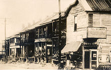
Tanyard Bottom, also known as Tech Flats, was a shantytown just south of Georgia Tech along Techwood Drive. It was replaced in the 1930s with the Techwood Homes, America's first public housing project.
This is an old revision of this page, as edited by Cydebot (talk | contribs) at 21:46, 8 October 2016 (Robot - Moving category Former shantytowns and slums in Atlanta, Georgia to Category:Former shantytowns and slums in Atlanta per CFD at Wikipedia:Categories for discussion/Log/2016 September 6.). The present address (URL) is a permanent link to this revision, which may differ significantly from the current revision.

Tanyard Bottom, also known as Tech Flats, was a shantytown just south of Georgia Tech along Techwood Drive. It was replaced in the 1930s with the Techwood Homes, America's first public housing project.
Former neighborhoods, districts and settlements of Atlanta, Georgia | |
|---|---|
| City districts and neighborhoods | |
| Planned but never built | |
| Settlements absorbed into Atlanta | |
| Shantytowns and slums | |
33°46′5.71″N 84°23′32.57″W / 33.7682528°N 84.3923806°W / 33.7682528; -84.3923806
This Atlanta, Georgia–related article is a stub. You can help Wikipedia by expanding it. |