
Winter Street (Boston)

Winter Street in Boston, Massachusetts is located between Tremont Street and Washington Street, near the Common. It is currently a pedestrian zone.[1] Prior to 1708, it was called Blott's Lane and then Bannister's Lane.[2][3]. It was also known at times as "Winer Street."[4]
See also
- Former tenants
- M.M. Ballou, publisher
- Deloss Barnum, photographer
- Central Church[5]
- Walter Lofthouse Dean, 3 Winter Street, painter[6]
- Draper & Folsom, publishers
- Fadettes of Boston
- Gilchrist's store
- A.N. Hardy, photographer
- Josiah Leavitt
- New England Emigrant Aid Company
- Polyanthos
- Henry and John Christian Rauschner, portraitists
- Schoenhof & Moeller
- S.R. Urbino, foreign books
References
Wikimedia Commons has media related to Winter Street (Boston).
- ^ City of Boston. "Street Book".
- ^ Boston Street Laying-Out Dept. A record of the streets, alleys, places, etc. in the city of Boston. Boston: City Printing Dept., 1910.
- ^ Thomas Wait Tucker. Bannisters Lane, 1708-1899: being sundry remarks, some historical and all new and interesting, on Bannisters Lane now named Winter Street and the district immediately thereabout. Boston: Shepard, Norwell & Co., 1899
- ^ "Burgiss's Map (1728)"., reprinted by Shurtleff, Topographical and Historical Description of Boston, 3d Edition, 1891, at p.92
- ^ "Central Church". Gleasons Pictorial. 5. Boston, Mass. 1853.
- ^ "Biennial Exhibition of Contemporary American Painting, Volumes 1–3," by Corcoran Gallery of Art
Image gallery
-
 Detail of 1743 map of Boston, showing Winter St. and vicinity
 -
 Ann Grayham, importer & retailer, 1767
 -
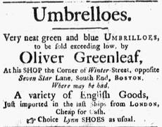 "Very neat green and blue umbrilloes, to be sold exceeding low, by Oliver Greenleaf," 1768 (Boston Evening-Post)
 -
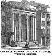 Central Congregational Church, c. 1851
 -
 Atlantic Monthly, no.1, 1857; published by Phillips, Sampson & Co., 13 Winter St.
 -
 Joseph Lyon's "umbrellas, parasols, canes, etc.," 1861
 -
 New England Crape and Lace Refinishing Co., c. 1870
 -
 Winter Street, Boston, March 2010


42°21′21.17″N 71°3′40.94″W / 42.3558806°N 71.0613722°W

This Massachusetts road-related article is a stub. You can help Wikipedia by expanding it. |