
Aravenu
Aravenu | |
|---|---|
village | |
| Country | |
| State | Tamil Nadu |
| Languages | |
| • Official | Tamil |
| Time zone | UTC+5:30 (IST) |
Aravenu is a village in Kotagiri Taluk of The Nilgiris District, Tamil Nadu, India.[1] The population is largely Badaga[1] and it is thought to be an original Badaga Hatti.[citation needed] It is the headquarters of the Jackanarai panchayat.[1]
It is located 5 km (3.1 mi) from Kothagiri on the Ooty to Mettupalayam State Highway 15.[1] This is one of the Nilgiri Ghat Roads. A further road links Aravenu directly with Coonoor via Bandishola.
Catherine Falls is located approximately 3 km (1.9 mi) from Aravenu.[2]
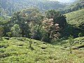
The area is rich in wildlife.[citation needed] Indian bison can be spotted grazing in the wooded areas. Other animals that thrive here include leopards, spotted deer and wild boar.
-
 Catherine Falls Shola
 -
 Amazing Valley
 -
 Catherine Falls


References
- ^ a b c d A Badaga-English Dictionary. 1992. p. 575. ISBN 311012677X.
{{cite book}}: Cite uses deprecated parameter|authors=(help) - ^ The Nilgiris: a guide to the blue Mountains of South India. 2006. p. 117.
{{cite book}}: Cite uses deprecated parameter|authors=(help)