
Canonica d'Adda
Canonica d'Adda | |
|---|---|
| Comune di Canonica d'Adda | |
.jpg) Canonica from across the Adda | |
 Coat of arms | |
Location of Canonica d'Adda  | |
 Canonica d'Adda Location of Canonica d'Adda in Italy  Canonica d'Adda Canonica d'Adda (Lombardy) | |
| Coordinates: 45°35′N 9°32′E / 45.583°N 9.533°E | |
| Country | Italy |
| Region | Lombardy |
| Province | Bergamo (BG) |
| Government | |
| • Mayor | Graziano Pirotta |
| Area | |
| • Total | 3.2 km2 (1.2 sq mi) |
| Elevation | 99 m (325 ft) |
| Population (Dec. 2004)[2] | |
| • Total | 3,944 |
| • Density | 1,200/km2 (3,200/sq mi) |
| Time zone | UTC+1 (CET) |
| • Summer (DST) | UTC+2 (CEST) |
| Postal code | 24040 |
| Dialing code | 02 |
| Patron saint | Santa Maria Assunta |
| Saint day | August 15 |
| Website | Official website |
Canonica d'Adda (Bergamasque: Calònega; Milanese: Canòniga) is a comune (municipality) in the Province of Bergamo in the Italian region of Lombardy, located about 30 kilometres (19 mi) northeast of Milan and about 15 kilometres (9 mi) southwest of Bergamo.
It lies on the left bank of the river Adda which separates it from Vaprio d'Adda and is here the boundary between the Province of Bergamo and the Province of Milan. Canonica d'Adda also borders the municipalities of Brembate, Capriate San Gervasio, Fara Gera d'Adda and Pontirolo Nuovo.
Demographic evolution

Gallery
-

Parish church -
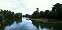
The Adda runs between Canonica d’Adda (on our right) and Vaprio d’Adda.

.jpg)
References
- ^ "Superficie di Comuni Province e Regioni italiane al 9 ottobre 2011". Italian National Institute of Statistics. Retrieved 16 March 2019.
- ^ All demographics and other statistics: Italian statistical institute Istat.
External links
Wikimedia Commons has media related to Canonica d'Adda.
| International | |
|---|---|
| Geographic | |
This article on a location in the Province of Bergamo is a stub. You can help Wikipedia by expanding it. |