
Upper Barbourville, New York
Upper Barbourville, New York | |
|---|---|
 Upper Barbourville, New York Location within the state of New York | |
| Coordinates: 42°09′36″N 75°21′20″W / 42.1600833°N 75.3554537°W[1] | |
| Country | United States |
| State | New York |
| County | Delaware |
| Town | Deposit |
| Elevation | 1,404 ft (428 m) |
| Time zone | UTC-5 (Eastern (EST)) |
| • Summer (DST) | UTC-4 (EDT) |
Upper Barbourville is a hamlet in Delaware County, New York. It is located northeast of Stilesville on NY Route 8. The East Branch Cold Spring Creek flows south through the hamlet.
References
Municipalities and communities of Delaware County, New York, United States | ||
|---|---|---|
| Towns | 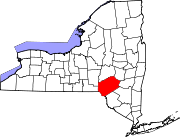 | |
| Villages | ||
| CDPs | ||
| Hamlets |
| |
| Footnotes | ‡This populated place also has portions in an adjacent county or counties | |
This article about a location in Delaware County, New York is a stub. You can help Wikipedia by expanding it. |