Santo Stefano in Aspromonte
Santo Stefano in Aspromonte | |
|---|---|
| Comune di Santo Stefano in Aspromonte | |
| Coordinates: 38°10′N 15°47′E / 38.167°N 15.783°E | |
| Country | Italy |
| Region | Calabria |
| Metropolitan city | Reggio Calabria (RC) |
| Frazioni | Gambarie, Mannoli |
| Area | |
| • Total | 17.7 km2 (6.8 sq mi) |
| Elevation | 715 m (2,346 ft) |
| Population (Dec. 2004)[2] | |
| • Total | 1,382 |
| • Density | 78/km2 (200/sq mi) |
| Demonym | Stefaniti |
| Time zone | UTC+1 (CET) |
| • Summer (DST) | UTC+2 (CEST) |
| Postal code | 89057 |
| Dialing code | 0965 |
| Website | www.comune.santostefanoinaspromonte.rc.it |
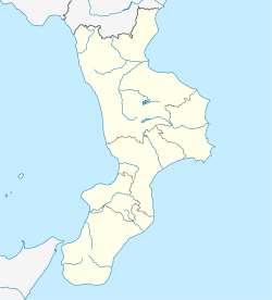
Santo Stefano in Aspromonte is a comune (municipality) in the Province of Reggio Calabria in the Italian region Calabria, located about 110 kilometres (68 mi) southwest of Catanzaro and about 12 kilometres (7 mi) northeast of Reggio Calabria. As of 31 December 2004, it had a population of 1,382 and an area of 17.7 square kilometres (6.8 sq mi).[3]


The municipality of Santo Stefano in Aspromonte contains the frazioni (subdivisions, mainly villages and hamlets) Gambarie and Mannoli. Gambarie's ski resort is one of the closest to the sea in the world,[citation needed] as it is situated just over the Strait of Messina.
Santo Stefano in Aspromonte borders the following municipalities: Gambarie, Mannoli, Laganadi, Calanna, Sambatello, Reggio Calabria, Roccaforte del Greco, Sant'Eufemia d'Aspromonte, San Roberto, Sant'Alessio in Aspromonte, Scilla, Podargoni, Cerasi and Schindilifà.
Demographics

See also
Notes and references
- ^ "Superficie di Comuni Province e Regioni italiane al 9 ottobre 2011". Italian National Institute of Statistics. Retrieved 16 March 2019.
- ^ "Popolazione Residente al 1° Gennaio 2018". Italian National Institute of Statistics. Retrieved 16 March 2019.
- ^ All demographics and other statistics: Italian statistical institute Istat.


