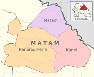
Kanel Department
Appearance
Kanel | |
|---|---|
 Location in the Matam Region | |
| Country | |
| Region | Matam Region |
| Capital | Kanel |
| Population (2013 census) | |
| • Total | 238,605 |
| Time zone | UTC+0 (GMT) |
Kanel Department is one of the 45 departments of Senegal, located in the Matam Region in the east of the country.
The department has six communes; Kanel, Semmé, Waounde, Dembakané, Hamady Ounaré and Sinthiou Bamambé-Banadji
The rural districts (Communautés rurales) comprise:
- Arrondissement of Orkadiere:
- Aouré
- Bokiladji
- Orkadiere
- Arrondissement of Wouro Sidy:
- Wouro Sidy
- Ndendory
Historic sites[1]
- Mausoleum of Cheikh Moussa Kamara at Ganguel
- The mosque of Kobilo
- The mosque of Séno Palel
- Mausoleum of Abdel Kader Kane
References
- ^ List of historic sites Archived 2012-02-20 at the Wayback Machine
15°29′30″N 13°10′35″W / 15.49167°N 13.17639°W
